National Register of Historic Places listings in Concordia Parish, Louisiana
This is a list of the National Register of Historic Places listings in Concordia Parish, Louisiana.
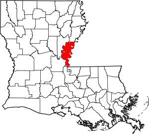
Location of Concordia Parish in Louisiana
This is intended to be a complete list of the properties on the National Register of Historic Places in Concordia Parish, Louisiana, United States. The locations of National Register properties for which the latitude and longitude coordinates are included below, may be seen in a map.[1]
There are 13 properties listed on the National Register in the parish. One property was once listed, but has since been removed.
- This National Park Service list is complete through NPS recent listings posted August 14, 2020.[2]
Current listings
| [3] | Name on the Register | Image | Date listed[4] | Location | City or town | Description |
|---|---|---|---|---|---|---|
| 1 | Canebrake | August 29, 1982 (#82002767) |
Along Maxwell Road, about 2.9 miles (4.7 km) east of Spokane, Louisiana and about 9.7 miles (15.6 km) northeast of Ferriday 31°41′56″N 91°24′41″W |
Ferriday | ||
| 2 | Concordia Parish Courthouse | 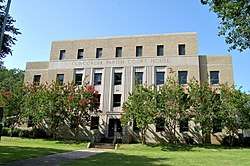 Concordia Parish Courthouse |
February 26, 2004 (#04000081) |
405 Carter Street 31°34′04″N 91°25′43″W |
Vidalia | |
| 3 | DePrato Mounds |  DePrato Mounds |
October 22, 1998 (#98001258) |
Address restricted[5] |
Ferriday | |
| 4 | Ferriday Commercial Historic District | 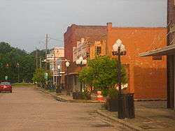 Ferriday Commercial Historic District |
January 27, 1995 (#94001584) |
Roughly bounded by South 1st Street, Louisiana Avenue, South 3rd Street and Mickey Gilley Avenue 31°37′46″N 91°33′10″W |
Ferriday | |
| 5 | Frogmore (16CO9) | 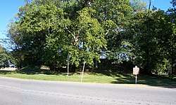 Frogmore (16CO9) |
July 28, 2004 (#04000740) |
Address restricted[5] |
Ferriday | |
| 6 | Gillespie | May 31, 1980 (#80001712) |
Frogmore Plantation, 11656 US 84, about 7 miles (11 km) west of Ferriday 31°36′24″N 91°40′07″W |
Ferriday | Frogmore Plantation House | |
| 7 | Killarney | February 18, 1999 (#99000235) |
Along LA 569, about 8 miles (13 km) northeast of Ferriday 31°42′32″N 91°27′01″W |
Ferriday | ||
| 8 | Lisburn Plantation House | July 26, 1979 (#79001057) |
Along Vidal Island Plantation Road, about 4.4 miles (7.1 km) northeast of Ferriday 31°40′16″N 91°29′50″W |
Ferriday | ||
| 9 | MAMIE S. BARRETT (towboat) | .jpg) MAMIE S. BARRETT (towboat) |
April 28, 1983 (#83002811) |
On land at Deer Park[6] 31°24′48″N 91°34′40″W |
Vidalia | Beached since the Great Flood of 1993[6] |
| 10 | Piazza Cotton Gin | 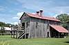 Piazza Cotton Gin |
January 27, 1999 (#99000049) |
Frogmore Plantation, 11656 US 84, about 7 miles (11 km) west of Ferriday 31°36′21″N 91°40′10″W |
Ferriday | |
| 11 | Roseland | October 10, 1985 (#85003002) |
916 Huntington Stadium Fisherman South Drive 31°37′12″N 91°32′20″W |
Ferriday | ||
| 12 | Tacony Plantation House | April 19, 1979 (#79001059) |
Along Taconey Plantation Road, about 450 yards (410 m) north of US 84 31°34′50″N 91°28′26″W |
Vidalia | ||
| 13 | Zappe Boarding House | 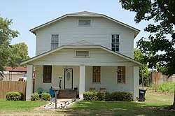 Zappe Boarding House |
February 18, 1999 (#99000232) |
107 Virginia Avenue 31°37′59″N 91°33′07″W |
Ferriday |
Former listings
| [3] | Name on the Register | Image | Date listed | Date removed | Location | City or town | Summary |
|---|---|---|---|---|---|---|---|
| 1 | Sheriff Eugene P. Campbell House | April 13, 1979 (#79001058) | November 29, 2016 | 2 Concordia Avenue 31°33′52″N 91°25′28″W |
Vidalia | Destroyed by fire on January 20, 1991.[7] |
gollark: I suppose you could do something with the linker.
gollark: Somehow?
gollark: Probably?
gollark: Sorry, typographical failure.
gollark: Sure! It will be entirely in Rust .Muahahahah.
See also
| Wikimedia Commons has media related to National Register of Historic Places in Concordia Parish, Louisiana. |
References
- The latitude and longitude information provided in this table was derived originally from the National Register Information System, which has been found to be fairly accurate for about 99% of listings. Some locations in this table may have been corrected to current GPS standards.
- "National Register of Historic Places: Weekly List Actions". National Park Service, United States Department of the Interior. Retrieved on August 14, 2020.
- Numbers represent an ordering by significant words. Various colorings, defined here, differentiate National Historic Landmarks and historic districts from other NRHP buildings, structures, sites or objects.
- The eight-digit number below each date is the number assigned to each location in the National Register Information System database, which can be viewed by clicking the number.
- Federal and state laws and practices restrict general public access to information regarding the specific location of this resource. In some cases, this is to protect archeological sites from vandalism, while in other cases it is restricted at the request of the owner. See: Knoerl, John; Miller, Diane; Shrimpton, Rebecca H. (1990), Guidelines for Restricting Information about Historic and Prehistoric Resources, National Register Bulletin, National Park Service, U.S. Department of the Interior, OCLC 20706997.
- Hogan, Vershal. "Deer Park Residents: Area Is Worth High-Water Hassles", Natchez Democrat, 2013-02-02. Accessed 2014-03-20.
- "National Register of Historic Places Request for Removal: Campbell, Sheriff Eugene P., House" (PDF). National Park Service. Retrieved May 2, 2018.

Municipalities and communities of Concordia Parish, Louisiana, United States | ||
|---|---|---|
Parish seat: Vidalia | ||
| Cities | | |
| Towns | ||
| CDPs | ||
| Other unincorporated communities | ||
This article is issued from Wikipedia. The text is licensed under Creative Commons - Attribution - Sharealike. Additional terms may apply for the media files.