National Register of Historic Places listings in West Baton Rouge Parish, Louisiana
This is a list of the National Register of Historic Places listings in West Baton Rouge Parish, Louisiana.
Location of West Baton Rouge Parish in Louisiana
This is intended to be a complete list of the properties on the National Register of Historic Places in West Baton Rouge Parish, Louisiana, United States. The locations of National Register properties for which the latitude and longitude coordinates are included below, may be seen in a map.[1]
There are 14 properties listed on the National Register in the parish. One property was once listed, but has since been removed.
- This National Park Service list is complete through NPS recent listings posted August 14, 2020.[2]
Current listings
| [3] | Name on the Register | Image | Date listed[4] | Location | City or town | Description |
|---|---|---|---|---|---|---|
| 1 | Aillet House | 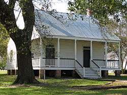 Aillet House |
August 9, 1991 (#91001046) |
845 N. Jefferson Ave. 30°27′35″N 91°12′22″W |
Port Allen | Permanent exhibit on the grounds of the West Baton Rouge Museum [5] |
| 2 | Allendale Plantation Historic District |  Allendale Plantation Historic District |
November 1, 1996 (#96001263) |
Junction of N. River Rd. and Allendale Rd. 30°29′45″N 91°16′24″W |
Port Allen | |
| 3 | Antonia |  Antonia |
August 1, 2008 (#08000743) |
4626 S. River Rd. 30°24′09″N 91°13′18″W |
Port Allen | (Louisiana's French Creole Architecture MPS) |
| 4 | Bank of Addis | 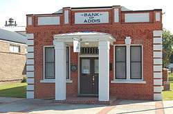 Bank of Addis |
February 13, 1992 (#92000038) |
7843 Ray Rivet St. 30°21′16″N 91°15′59″W |
Addis | |
| 5 | Cinclare Sugar Mill Historic District |  Cinclare Sugar Mill Historic District |
April 23, 1998 (#98000394) |
Junction of Louisiana Highway 1 and Terrell Dr. 30°23′46″N 91°13′55″W |
Brusly | |
| 6 | Hebert House | 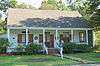 Hebert House |
October 7, 1993 (#93001032) |
919 E. Main St. 30°23′13″N 91°14′02″W |
Brusly | |
| 7 | Homestead Plantation | September 22, 2016 (#16000674) |
1323 N. River Rd. 30°28′00″N 91°12′11″W |
Port Allen | ||
| 8 | Monte Vista Plantation House | June 9, 1980 (#80001769) |
North of Port Allen 30°30′10″N 91°12′11″W |
Port Allen | ||
| 9 | Old Brusly High School Gymnasium | 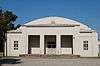 Old Brusly High School Gymnasium |
September 20, 2007 (#07000983) |
601 N. Kirkland Dr. 30°23′24″N 91°13′58″W |
Brusly | |
| 10 | Poplar Grove Plantation House | December 14, 1987 (#87002136) |
3142 N. River Rd. 30°29′35″N 91°12′09″W |
Port Allen | ||
| 11 | Port Allen High School | 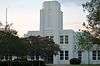 Port Allen High School |
April 20, 1989 (#89000326) |
610 Rosedale St. 30°27′50″N 91°12′26″W |
Port Allen | |
| 12 | St. Mark's Baptist Church and Ashland Cemetery | 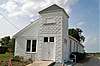 St. Mark's Baptist Church and Ashland Cemetery |
February 21, 2018 (#100002116) |
6025 Section Rd. 30°32′18″N 91°17′44″W |
Port Allen | |
| 13 | Sandbar Plantation House | 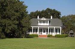 Sandbar Plantation House |
September 2, 1999 (#99001039) |
4234 S. River Rd. 30°24′31″N 91°13′02″W |
Port Allen | |
| 14 | Smithfield Plantation House | 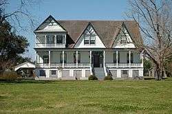 Smithfield Plantation House |
April 7, 1995 (#95000387) |
12445 N. River Rd. 30°32′59″N 91°17′27″W |
Port Allen |
Former listing
| [3] | Name on the Register | Image | Date listed | Date removed | Location | City or town | Summary |
|---|---|---|---|---|---|---|---|
| 1 | Cohn High School | 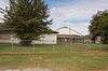 Cohn High School |
June 22, 2004 (#04000638) | March 31, 2015 | 805 N. 14th St. 30°27′34″N 91°13′05″W |
Port Allen |
gollark: Doesn't matter, GPU beats it.
gollark: But not everything can easily be broken into parallelisable chunks, so CPUs are more widely used.
gollark: Basically, GPUs are faster, given that they have several thousand cores at 1-2GHz vs the 2-8 cores at 3-5GHz on CPUs.
gollark: ^
gollark: You should *only* use GPU miners.
See also
| Wikimedia Commons has media related to National Register of Historic Places in West Baton Rouge Parish, Louisiana. |
References
- The latitude and longitude information provided in this table was derived originally from the National Register Information System, which has been found to be fairly accurate for about 99% of listings. Some locations in this table may have been corrected to current GPS standards.
- "National Register of Historic Places: Weekly List Actions". National Park Service, United States Department of the Interior. Retrieved on August 14, 2020.
- Numbers represent an ordering by significant words. Various colorings, defined here, differentiate National Historic Landmarks and historic districts from other NRHP buildings, structures, sites or objects.
- The eight-digit number below each date is the number assigned to each location in the National Register Information System database, which can be viewed by clicking the number.
- http://www.westbatonrougemuseum.com/index.php?option=com_k2&view=itemlist&layout=category&task=category&id=26&Itemid=76
| Topics | |
|---|---|
| Lists by state |
|
| Lists by insular areas | |
| Lists by associated state | |
| Other areas | |
| Related | |
| |
Municipalities and communities of West Baton Rouge Parish, Louisiana, United States | ||
|---|---|---|
Parish seat: Port Allen | ||
| City | | |
| Towns | ||
| CDP | ||
| Unincorporated communities | ||
This article is issued from Wikipedia. The text is licensed under Creative Commons - Attribution - Sharealike. Additional terms may apply for the media files.