National Register of Historic Places listings in Richland Parish, Louisiana
This is a list of the National Register of Historic Places listings in Richland Parish, Louisiana.
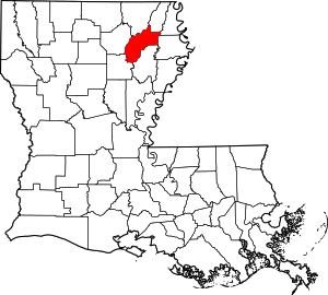
Location of Richland Parish in Louisiana
This is intended to be a complete list of the properties on the National Register of Historic Places in Richland Parish, Louisiana, United States. The locations of National Register properties for which the latitude and longitude coordinates are included below, may be seen in a map.[1]
There are 9 properties listed on the National Register in the parish. One property was once listed, but has since been removed.
- This National Park Service list is complete through NPS recent listings posted August 14, 2020.[2]
Current listings
| [3] | Name on the Register | Image | Date listed[4] | Location | City or town | Description |
|---|---|---|---|---|---|---|
| 1 | Delhi Municipal Baseball Park | January 28, 2000 (#00000007) |
Chicago and Louisiana Sts. 32°27′19″N 91°29′48″W |
Delhi | ||
| 2 | Downtown Delhi Historic District | 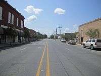 Downtown Delhi Historic District |
March 14, 1997 (#97000234) |
606-708 1st St. and 115-201 Broadway 32°27′26″N 91°29′36″W |
Delhi | |
| 3 | Marsden Mounds | August 4, 2004 (#04000803) |
32°29′11″N 91°29′30″W |
Delhi | A multimound archaeological site near Delhi, Louisiana, with a Poverty Point period component (1500 BCE) and a Coles Creek component (400 to 1200 CE).[5] | |
| 4 | Miles-Hanna House | October 18, 1996 (#96001161) |
206 Charter 32°27′31″N 91°29′36″W |
Delhi | ||
| 5 | Poplar Chapel AME Church | June 2, 1989 (#89000475) |
Louisiana Highway 135 32°23′55″N 91°50′02″W |
Rayville | ||
| 6 | Rayville High School | 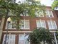 Rayville High School |
October 29, 1992 (#92001491) |
109 Madeline St. 32°28′33″N 91°45′25″W |
Rayville | |
| 7 | Nonnie Roark Rhymes Memorial Library | 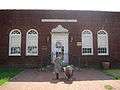 Nonnie Roark Rhymes Memorial Library |
November 2, 1990 (#90001736) |
206 S. Louisa St. 32°28′31″N 91°45′25″W |
Rayville | |
| 8 | St. David's Episcopal Church | September 27, 2007 (#07001006) |
834 Louisa St. 32°28′27″N 91°45′29″W |
Rayville | ||
| 9 | Trio Plantation House | February 26, 1999 (#99000257) |
312 Trio Rd. 32°32′00″N 91°43′07″W |
Rayville | ||
| 10 | Vickers House | 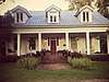 Vickers House |
May 15, 1986 (#86001056) |
Louisiana Highway 15 32°21′27″N 91°51′37″W |
Alto |
Former listing
| [3] | Name on the Register | Image | Date listed | Date removed | Location | City or town | Summary |
|---|---|---|---|---|---|---|---|
| 3 | Mangham State Bank Building | May 9, 1985 (#85000975) | May 2, 2016 | Main and Horace Sts. 32°18′29″N 91°46′33″W |
Mangham |
gollark: This is obviously true for *some* stuff like mental maths.
gollark: Also if you're acting based on it.
gollark: Well, if you're arguing based on it, I think it would be useful to know.
gollark: Is this actually true?
gollark: I think the more interesting question is what it's actually doing at a high level, i.e. what algorithms the entire accursedly complex mess runs. There might be a relatively nice explanation which covers some parts.
See also
| Wikimedia Commons has media related to National Register of Historic Places in Richland Parish, Louisiana. |
References
- The latitude and longitude information provided in this table was derived originally from the National Register Information System, which has been found to be fairly accurate for about 99% of listings. Some locations in this table may have been corrected to current GPS standards.
- "National Register of Historic Places: Weekly List Actions". National Park Service, United States Department of the Interior. Retrieved on August 14, 2020.
- Numbers represent an ordering by significant words. Various colorings, defined here, differentiate National Historic Landmarks and historic districts from other NRHP buildings, structures, sites or objects.
- The eight-digit number below each date is the number assigned to each location in the National Register Information System database, which can be viewed by clicking the number.
- "Indian Mounds of Northeast Louisiana:Marsden Mounds". Archived from the original on 2013-05-14. Retrieved 2011-10-22.
| Topics | |
|---|---|
| Lists by state |
|
| Lists by insular areas | |
| Lists by associated state | |
| Other areas | |
| Related | |
| |
Municipalities and communities of Richland Parish, Louisiana, United States | ||
|---|---|---|
Parish seat: Rayville | ||
| Towns | | |
| Village | ||
| CDP | ||
| Other unincorporated communities | ||
| Footnotes | ‡This populated place also has portions in an adjacent parish or parishes | |
This article is issued from Wikipedia. The text is licensed under Creative Commons - Attribution - Sharealike. Additional terms may apply for the media files.