Nash, North Dakota
Nash is a census-designated place and unincorporated community in Walsh County, North Dakota, United States. Its population was 32 as of the 2010 census.[2] The unincorporated community is located in Farmington Township, northwest of Grafton, North Dakota.
Nash | |
|---|---|
 Entering Nash, North Dakota from the East | |
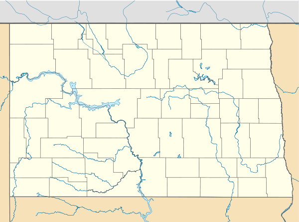 Nash Location within the state of North Dakota  Nash Nash (the United States) | |
| Coordinates: 48°28′14″N 97°30′47″W | |
| Country | United States |
| State | North Dakota |
| County | Walsh |
| Area | |
| • Total | 1.02 sq mi (2.65 km2) |
| • Land | 1.02 sq mi (2.65 km2) |
| • Water | 0 sq mi (0 km2) |
| Elevation | 853 ft (260 m) |
| Population (2010)[2] | |
| • Total | 32 |
| • Density | 31/sq mi (12/km2) |
| Time zone | UTC-6 (Central (CST)) |
| • Summer (DST) | UTC-5 (CDT) |
| ZIP code | 58237 |
| Area code(s) | 701 |
| FIPS code | 38-55500 |
| GNIS feature ID | 1030355[3] |
Nash was designated as part of the U.S. Census Bureau's Participant Statistical Areas Program on March 31, 2010.[4] It was not counted separately during the 2000 Census,[5] but was included in the 2010 Census,[6] where a population of 32 was reported.[2]
History
It was founded in 1890 as a station along the Great Northern Railroad and named for the Nash brothers, pioneer settlers in the area who operated a fruit store in Grafton and started what is now the Nash Finch Company, the third-largest food wholesaler in the United States.[7][8]
Geography
Nash is located at 48°28′14″N 97°30′47″W (48.470556, -97.513056).[1]
According to the United States Census Bureau, the CDP has a total area of 1.02 square miles (2.64 km2), all of it land.[1]
Demographics
2010 census
As of the census[2] of 2010, there were 32 people, 12 households, and 9 families in the CDP. The population density was 31.3 inhabitants per square mile (12.1/km2). There were 13 housing units at an average density of 12.7 per square mile (4.9/km2). The racial makeup of the CDP was 93.8% White, and 6.3% from other races. Hispanic or Latino of any race were 28.1% of the population.
There were 12 households of which 25.0% had children under the age of 18 living with them, 50.0% were married couples living together, 16.7% had a female householder with no husband present, 8.3% had a male householder with no wife present, and 25.0% were non-families. 16.7% of all households were made up of individuals and 8.3% had someone living alone who was 65 years of age or older. The average household size was 2.67 and the average family size was 3.11.
The median age in the CDP was 37.5 years. 25.0% of residents were under the age of 18; 12.5% were between the ages of 18 and 24; 15.6% were from 25 to 44; 37.5% were from 45 to 64; and 9.4% were 65 years of age or older. The gender makeup of the CDP was 50.0% male and 50.0% female.
References
- "US Gazetteer files: 2010, 2000, and 1990". United States Census Bureau. 2011-02-12. Retrieved 2011-04-23.
- "2010 Census Redistricting Data (Public Law 94-171) Summary File". American FactFinder. United States Census Bureau. Retrieved 2 May 2011.
- "Nash". Geographic Names Information System. United States Geological Survey.
- "Nash Census Designated Place". Geographic Names Information System. United States Geological Survey. Retrieved 2010-07-13.
- U.S. Census Bureau (2003). "Population and Housing Unit Counts, North Dakota" (PDF). 2000 Census of Population and Housing. Government Printing Office. Retrieved 2008-07-20.
- U.S. Census Bureau (February 13, 2008). "Census Designated Place (CDP) Program for the 2010 Census—Final Criteria" (PDF). Federal Register. Archived from the original (PDF) on October 18, 2010. Retrieved 2010-07-13.
- Wick, Douglas A. (1988). North Dakota Place Names. Bismarck, North Dakota: Hedemarken Collectibles. p. 135. ISBN 0-9620968-0-6. OCLC 191277027.
- Williams, Mary Ann (Barnes) (1966). Origins of North Dakota Place Names. Bismarck, North Dakota: Bismarck Tribune, 1966. p. 328. OCLC 431626.
Municipalities and communities of Walsh County, North Dakota, United States | ||
|---|---|---|
| Cities | 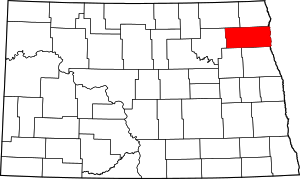 Map of North Dakota highlighting Walsh County | |
| Townships | ||
| CDPs | ||
| Unincorporated communities | ||