Naryn
Naryn (Kyrgyz: Нарын, Narın, نارىن) is the regional administrative center of Naryn Region in central Kyrgyzstan. Its area is 84 square kilometres (32 sq mi), and its estimated population was 40,000 as of January 2019.[1] The town was established as a fortress on the caravan route in 1868.[2] It is situated on both banks of the Naryn River (one of the main head waters of the Syr Darya), which cuts a picturesque gorge through the town. The city has two regional museums and some hotels, but is otherwise residential.
Naryn | |
|---|---|
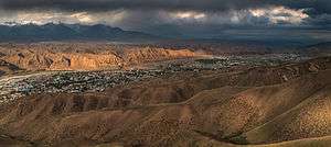 Overlook of Naryn from the south | |
 Flag  Seal | |
 Naryn Location in Kyrgyzstan | |
| Coordinates: 41°26′N 76°0′E | |
| Country | |
| Region | Naryn Region |
| Naryn | 1868 |
| Area | |
| • Total | 84 km2 (32 sq mi) |
| Elevation | 2,044 m (6,706 ft) |
| Population (2019)[1] | |
| • Total | 40,000 |
| • Density | 480/km2 (1,200/sq mi) |
| residential population | |
| Time zone | UTC+6 (KGT) |
| 722900 | 722600 |
| Area code(s) | 722600 |
History

Naryn was established as a fortress on the important caravan route between Kashgar and Zhetysu (Semirechye) at the direction of the first Governor-General of Russian Turkestan Konstantin Petrovich von Kaufmann in 1868.[3]
Overview
From Naryn, the main road (one of the branches of the ancient Silk Road) runs south through the sparsely settled central Kyrgyz highlands to the Torugart Pass and China. At present, this is the main transport link from Kyrgyzstan to China. Naryn hosts one of three campuses of the University of Central Asia (UCA). The University was founded in 2000 by the governments of Kazakhstan, the Kyrgyz Republic and Tajikistan, and His Highness the Aga Khan. It is the world's first internationally chartered institution of higher education. The UCA currently operates a School of Professional and Continuing Education (SPCE), with a School of Undergraduate Studies and a Graduate School of Development in the process of being established. Undergraduate classes at the University of Central Asia’s (UCA) Naryn, Kyrgyz Republic campus commenced on 5 September 2016.[4]
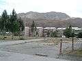 Apartment buildings in Naryn
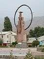 Statue in the main square of Naryn
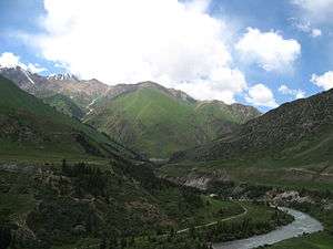 Countryside around Naryn.
| Year | Pop. | ±% |
|---|---|---|
| 1926 | 1,632 | — |
| 1959 | 6,033 | +269.7% |
| 1970 | 21,098 | +249.7% |
| 1979 | 30,409 | +44.1% |
| 1989 | 42,709 | +40.4% |
| 1999 | 40,429 | −5.3% |
| 2009 | 34,822 | −13.9% |
| 2019 | 40,000 | +14.9% |
| Source:[6][7][1] | ||
Demographics
Naryn is the tenth largest city by population in Kyrgyzstan. Its de facto population, according to the Population and Housing Census of 2009, was 34,226. The population of the district as a whole was 44,080 people according to the 2009 census. According to the National Statistical Committee the population of Naryn amounted to 40,000 as of January 2019.[1]
Economics
The economy of the Province is dominated by animal husbandry such as horse, sheep and yak, and wool and meat being the main products. Today, the district is the poorest region in the country. The mineral mines developed during the Soviet period were largely abandoned after the fall of communism as they were not profitable.
Climate
Naryn has a cold semi-arid climate (Köppen climate classification BSk) with strong continental tendencies.
| Climate data for Naryn (1961–1990) | |||||||||||||
|---|---|---|---|---|---|---|---|---|---|---|---|---|---|
| Month | Jan | Feb | Mar | Apr | May | Jun | Jul | Aug | Sep | Oct | Nov | Dec | Year |
| Record high °C (°F) | 2 (36) |
2 (36) |
20 (68) |
27 (81) |
28 (82) |
31 (88) |
30 (86) |
34 (93) |
28 (82) |
22 (72) |
10 (50) |
0 (32) |
34 (93) |
| Average high °C (°F) | −9.7 (14.5) |
−6.6 (20.1) |
2.9 (37.2) |
13.9 (57.0) |
17.9 (64.2) |
21.5 (70.7) |
24.5 (76.1) |
24.9 (76.8) |
20.2 (68.4) |
12.7 (54.9) |
2.2 (36.0) |
−6.4 (20.5) |
9.9 (49.8) |
| Daily mean °C (°F) | −15.8 (3.6) |
−12.5 (9.5) |
−2.5 (27.5) |
7.7 (45.9) |
11.6 (52.9) |
14.7 (58.5) |
17.3 (63.1) |
17.6 (63.7) |
12.9 (55.2) |
6.0 (42.8) |
−3.5 (25.7) |
−11.9 (10.6) |
3.5 (38.3) |
| Average low °C (°F) | −20.4 (−4.7) |
−17.3 (0.9) |
−6.5 (20.3) |
2.3 (36.1) |
6.1 (43.0) |
8.5 (47.3) |
10.7 (51.3) |
10.4 (50.7) |
6.2 (43.2) |
0.6 (33.1) |
−7.6 (18.3) |
−16.1 (3.0) |
−1.9 (28.6) |
| Record low °C (°F) | −36 (−33) |
−28 (−18) |
−24 (−11) |
−8 (18) |
−1 (30) |
2 (36) |
4 (39) |
2 (36) |
−7 (19) |
−11 (12) |
−26 (−15) |
−33 (−27) |
−36 (−33) |
| Average precipitation mm (inches) | 9.7 (0.38) |
13.4 (0.53) |
19.8 (0.78) |
34.0 (1.34) |
48.5 (1.91) |
54.8 (2.16) |
37.3 (1.47) |
20.8 (0.82) |
17.3 (0.68) |
15.1 (0.59) |
10.9 (0.43) |
9.5 (0.37) |
291.1 (11.46) |
| Average precipitation days (≥ 1.0 mm) | 3.1 | 5.8 | 5.6 | 6.8 | 9.4 | 10.0 | 7.2 | 4.4 | 3.3 | 3.3 | 3.3 | 2.7 | 62.9 |
| Average relative humidity (%) | 76 | 74 | 71 | 60 | 54 | 57 | 55 | 50 | 45 | 52 | 63 | 74 | 61 |
| Mean monthly sunshine hours | 135 | 145 | 178 | 210 | 246 | 292 | 320 | 316 | 274 | 218 | 156 | 122 | 2,612 |
| Source 1: Deutscher Wetterdienst[8] | |||||||||||||
| Source 2: NOAA (sun, 1961–1990)[9] | |||||||||||||
References
- "Population census of the regions, rayons, towns, and urban-type settlements of Kyrgyz Republic". 2019-01-01. Retrieved 2019-07-19.
- Иссык-Куль. Нарын. Энциклопедия. [Issyk-Kul. Naryn.Encyclopedia.] (in Russian). Frunze: Chief Editorial Board of Kyrgyz Soviet Encyclopedia. 1991. p. 512. ISBN 5-89750-009-6.
- Pavlov, N. (1910). The history of Turkestan (in Russian). p. 143. Retrieved 2019-07-20.
- "Classes Begin for the University of Central Asia's First Undergraduate Students". University of Central Asia. Archived from the original on 26 October 2017. Retrieved 10 October 2016.
- Info on www.canadabandy.ca Archived 2005-08-28 at the Wayback Machine
- "Всесоюзная перепись населения 1926 года : Киргизская АССР. (All-Union Census of 1926: Kyrgyz ASSR)". Moscow: CSU SSSR. 1928. Archived from the original on 2011-07-22. Retrieved 2013-04-14. Cite journal requires
|journal=(help) - Всесоюзная перепись населения 1959 г. All Union Census of 1959. (Demoscope.ru) (in Russian)
- "Klimatafel von Naryn (Narynskoje) / Kirgisistan" (PDF). Baseline climate means (1961-1990) from stations all over the world (in German). Deutscher Wetterdienst. Retrieved 18 February 2016.
- "Naryn (MTN STN) Climate Normals 1961–1990". National Oceanic and Atmospheric Administration. Retrieved 18 February 2016.
External links
![]()
- Celestial Mountains Travel Encyclopedia of Kyrgyzstan [English]
- Photos from Naryn [English]
Administrative seats of the regions of Kyrgyzstan | |||
|---|---|---|---|