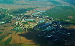
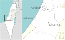
Nahala, Israel
Nahala (Hebrew: נַחֲלָה, lit. Estate) is a moshav in south-central Israel. Located a few kilometers north of Kiryat Gat and south of Kiryat Malakhi., it falls under the jurisdiction of Yoav Regional Council. In 2018 it had a population of 718.[1]
Nahala נַחֲלָה | |
|---|---|
 | |
 Nahala | |
| Coordinates: 31°39′33.11″N 34°47′39.11″E | |
| Country | Israel |
| District | Southern |
| Council | Yoav |
| Affiliation | Moshavim Movement |
| Founded | 1953 |
| Population (2018)[1] | 718 |
History
The community was founded in 1953 by Yemeni Jewish refugees on land that had belonged to the depopulated Palestinian village of Summil.[2] The founders had originally established moshav Agur in 1950.[3] Along with the neighboring Menuha, it was named for the Menuha VeNahala (Hebrew: מנוחה ונחלה) organization that founded Rehovot.
gollark: If I send the thing messages via `socat` on the same host to `ff02::aeae`, it now receives them, but it won't work between different devices which can ping each others' link local IPs.
gollark: So I managed to make it not work for different reasons.
gollark: My THING is not WORKING!
gollark: This is so apioformic, it should let me apiobind to `[ff02::aeae]:44718`!
gollark: Apparently my apiosocket won't apiobind?
See also
- Nahala (disambiguation page), Hebrew word for heritage or estate widely used for toponyms in Israel
References
| Wikimedia Commons has media related to Nahala. |
- "Population in the Localities 2018" (XLS). Israel Central Bureau of Statistics. 25 August 2019. Retrieved 26 August 2019.
- Khalidi, Walid (1992). All That Remains: The Palestinian Villages Occupied and Depopulated by Israel in 1948. Washington D.C.: Institute for Palestine Studies. p. 137. ISBN 0-88728-224-5.
- Agur Homee
This article is issued from Wikipedia. The text is licensed under Creative Commons - Attribution - Sharealike. Additional terms may apply for the media files.