Myanzi
Myanzi is a small town in the Central Region of Uganda.
Myanzi | |
|---|---|
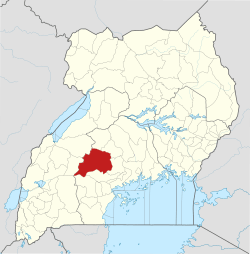
 Myanzi Location in Uganda Placement on map is approximate | |
| Coordinates: 00°15′30″N 31°30′18″E | |
| Country | |
| Region | Central Uganda |
| District | Mubende District |
| Municipality | Myanzi |
| County | Buweekula |
| Elevation | 3,957 ft (1,206 m) |
Location
Myanzi is in Mubende District on the Mityana–Mubende Road, approximately 17 kilometres (11 mi), by road, west of Mityana, the nearest large town.[1] The coordinates of Myanzi are 0°26'15.0"N, 31°54'38.0"E (Latitude:0.437501; Longitude:31.910547).[2] The town sits at an average elevation of 1,206 metres (3,957 ft) above sea level.[3]
Overview
The Myanzi–Kassanda–Bukuya–Kiboga Road meets the Mityana–Mubende Road at a T-junction in the middle of town.[4]
gollark: Oh, wait, it actually declares a `sorted`, bee.
gollark: #1 is kind of weird because it does some complex stuff then just ignores it and does `sorted`.
gollark: ```python@worddef debugAt(): print(next())```
gollark: The decorators are oddly placed.
gollark: Is #15 *deliberately* written to be weirdly formatted?
References
- GFC (18 May 2016). "Distance between Mityana Taxi Park, Market Road, Mityana, Central Region, Uganda and Myanzi, Central Region, Uganda". Globefeed.com (GFC). Retrieved 18 May 2016.
- Google (18 May 2016). "Location of Myanzi, Mubende District, Central Region, Uganda" (Map). Google Maps. Google. Retrieved 18 May 2016.
- FMN (18 May 2016). "Elevation of Myanzi,Uganda". Floodmap.net (FMN). Retrieved 18 May 2016.
- Google (18 May 2016). "Location of Junction Between Myanzi–Kassanda–Bukuya–Kiboga Road And Mityana–Mubende Road" (Map). Google Maps. Google. Retrieved 18 May 2016.
This article is issued from Wikipedia. The text is licensed under Creative Commons - Attribution - Sharealike. Additional terms may apply for the media files.
