Mungungo
Mungungo is a rural town and locality in the North Burnett Region, Queensland, Australia.[2][3] In the 2016 census, Mungungo had a population of 77 people.[1]
| Mungungo Queensland | |||||||||||||||
|---|---|---|---|---|---|---|---|---|---|---|---|---|---|---|---|
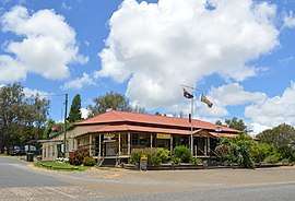 Waratah Hotel at Mungungo, 2017 | |||||||||||||||
 Mungungo | |||||||||||||||
| Coordinates | 24.7672°S 151.1638°E | ||||||||||||||
| Population | 77 (2016 census)[1] | ||||||||||||||
| • Density | 0.752/km2 (1.948/sq mi) | ||||||||||||||
| Postcode(s) | 4630 | ||||||||||||||
| Area | 102.4 km2 (39.5 sq mi) | ||||||||||||||
| Time zone | AEST (UTC+10:00) | ||||||||||||||
| Location | |||||||||||||||
| LGA(s) | North Burnett Region | ||||||||||||||
| State electorate(s) | Callide | ||||||||||||||
| Federal Division(s) | Flynn | ||||||||||||||
| |||||||||||||||
Geography
Mungungo is in the Wide Bay-Burnett region, 488 kilometres (303 mi) north west of the state capital, Brisbane.
History
The name Mungungo is believed to mean "darkness" or "night" in an unidentified indigenous language. Until 1929, the town was known as Waratah.[3]
The Gladstone to Monto railway line reached Mungungo in 1930.
Amenities
Mungungo is well known throughout the surrounding land for its pub which is one of the few available eateries in the area.
gollark: It's somewhat bad for people *other* than the billion-dollar corporations, they just don't get noticed much because they're... not billion-dollar corporations.
gollark: I mean, sure, but it is an actual problem.
gollark: Yes, and?
gollark: On Android you can sideload at least.
gollark: It's a problematic system.
References
- Australian Bureau of Statistics (27 June 2017). "Mungungo (SSC)". 2016 Census QuickStats. Retrieved 20 October 2018.

- "Mungungo - town in North Burnett Region (entry 23491)". Queensland Place Names. Queensland Government. Retrieved 30 November 2019.
- "Mungungo - locality in North Burnett Region (entry 45400)". Queensland Place Names. Queensland Government. Retrieved 30 November 2019.
This article is issued from Wikipedia. The text is licensed under Creative Commons - Attribution - Sharealike. Additional terms may apply for the media files.