Mount Vernon Township, Jefferson County, Illinois
Mount Vernon Township is one of sixteen townships in Jefferson County, Illinois, USA. As of the 2010 census, its population was 13,374 and it contained 6,422 housing units.[2]
Mount Vernon Township | |
|---|---|
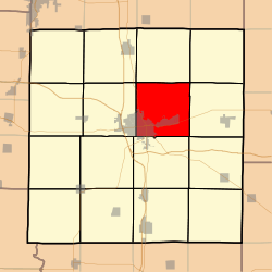 Location in Jefferson County | |
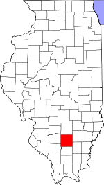 Jefferson County's location in Illinois | |
| Coordinates: 38°21′N 88°52′W | |
| Country | United States |
| State | Illinois |
| County | Jefferson |
| Area | |
| • Total | 37.21 sq mi (96.4 km2) |
| • Land | 36.95 sq mi (95.7 km2) |
| • Water | 0.26 sq mi (0.7 km2) 0.70% |
| Elevation | 528 ft (161 m) |
| Population (2010) | |
| • Estimate (2016)[1] | 13,216 |
| • Density | 362/sq mi (140/km2) |
| Time zone | UTC-6 (CST) |
| • Summer (DST) | UTC-5 (CDT) |
| ZIP codes | 62864, 62872 |
| FIPS code | 17-081-51193 |
Geography
According to the 2010 census, the township has a total area of 37.21 square miles (96.4 km2), of which 36.95 square miles (95.7 km2) (or 99.30%) is land and 0.26 square miles (0.67 km2) (or 0.70%) is water.[2] The township is centered at 38°21′N 88°52′W (38.349,-88.859). It is traversed north-south by State Route 37, east-west by State Route 15, and diagonally across its southwest corner by State Route 142.
Cities, towns, villages
Unincorporated towns
- Camp Ground at 38.339°N 88.836°W
- Idlewood at 38.380°N 88.9223°W
- Summersville at 38.328°N 88.867°W
(This list is based on USGS data and may include former settlements.)
Adjacent townships
- Field Township (north)
- Farrington Township (northeast)
- Webber Township (east)
- Pendleton Township (southeast)
- Dodds Township (south)
- Shiloh Township (west)
- Rome Township (northwest)
Cemeteries
The township contains these nine cemeteries: Atkinson, East Salem, Etheridge Farm, Hopewell, Oakwood, Old Union, Saint Mary's, Sursa and Williams.
Major highways
Airports and landing strips
- Good Samaritan Regional Health Care Center Heliport
- Mount Vernon/Outland Airport
Political districts
- Illinois' 19th congressional district
- State House District 107
- State Senate District 54
References
- "Mount Vernon Township, Jefferson County, Illinois". Geographic Names Information System. United States Geological Survey. Retrieved 2010-01-17.
- United States Census Bureau 2007 TIGER/Line Shapefiles
- United States National Atlas
- "Population and Housing Unit Estimates". Retrieved June 9, 2017.
- "Population, Housing Units, Area, and Density: 2010 - County -- County Subdivision and Place -- 2010 Census Summary File 1". United States Census. Archived from the original on 2020-02-12. Retrieved 2013-05-28.
- "Census of Population and Housing". Census.gov. Retrieved June 4, 2016.
External links
Municipalities and communities of Jefferson County, Illinois, United States | ||
|---|---|---|
| Cities | Map of Illinois highlighting Jefferson County | |
| Villages | ||
| Townships | ||
| CDP | ||
| Other unincorporated communities |
| |
| Footnotes | ‡This populated place also has portions in an adjacent county or counties | |