Mount Paul
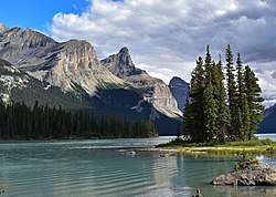
Mount Paul is a 2,850 metre mountain summit towering 1134 metres above the east shore of Maligne Lake in Jasper National Park, in the Canadian Rockies of Alberta, Canada. The nearest higher peak is Maligne Mountain, 1.81 km (1.12 mi) to the north-northwest.[5] Mount Paul is situated north of Monkhead and they are often seen together in the background of iconic calendar photos of Spirit Island and Maligne Lake.
| Mount Paul | |
|---|---|
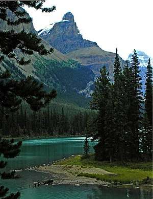 Mount Paul seen from Samson Narrows on Maligne Lake | |
| Highest point | |
| Elevation | 2,850 m (9,350 ft) [1] |
| Prominence | 175 m (574 ft) [1] |
| Parent peak | Maligne Mountain (3200 m)[1] |
| Coordinates | 52°36′55″N 117°25′40″W [2] |
| Geography | |
 Mount Paul Location of Mount Paul in Alberta  Mount Paul Mount Paul (Canada) | |
| Location | Alberta, Canada |
| Parent range | Queen Elizabeth Ranges Canadian Rockies |
| Topo map | NTS 83C/11[2] |
| Geology | |
| Age of rock | Cambrian / Ordovician [3] |
| Type of rock | Limestone |
| Climbing | |
| First ascent | 1928 by W.R. Hainsworth and M.M. Strumia[4] |
History
Mount Paul was named by Mary Schäffer after Paul Sharples, Mary's nine year old nephew who accompanied her on her second expedition to Maligne Lake in 1911.[6] Mary originally referred to this mountain as The Thumb during her first successful expedition to Maligne Lake in 1908.
The first ascent of Mount Paul was made in 1928 by W.R. Hainsworth and M.M. Strumia[7] This mountain's name was officially adopted in 1946 by the Geographical Names Board of Canada.[2]
Climate
Based on the Köppen climate classification, Mount Paul is located in a subarctic climate with cold, snowy winters, and mild summers.[8] Temperatures can drop below -20 °C with wind chill factors below -30 °C. Precipitation runoff from Mount Paul drains west into Maligne Lake, thence into the Maligne River which is a tributary of the Athabasca River.
See also
References
- "Mount Paul". Bivouac.com. Retrieved 2018-10-22.
- "Mount Paul". Geographical Names Data Base. Natural Resources Canada. Retrieved 2018-10-22.
- https://ags.aer.ca/document/OFR/OFR_1964_01.pdf
- Mount PaulPeakFinder
- "Mount Paul, Alberta". Peakbagger.com.
- Mount PaulPeakFinder
- Mount PaulPeakFinder
- Peel, M. C.; Finlayson, B. L. & McMahon, T. A. (2007). "Updated world map of the Köppen−Geiger climate classification". Hydrol. Earth Syst. Sci. 11: 1633–1644. ISSN 1027-5606.
External links
- Parks Canada web site: Jasper National Park
- Mount Paul weather: Mountain Forecast