Mount Gibbo
Mount Gibbo is a mountain in the Australian Alps. It is 38 kilometres to the north-east of Benambra in Victoria, Australia and lies within the Mount Gibbo Natural Features and Scenic Reserve managed by Parks Victoria.[2] The reserve, which covers 1493.1 hectares, was established in 1979.[3] On the northern side of the mountain, Ordovician sediments are exposed on the steep slopes.[4] Surrounding peaks include Mount Pinnibar (1772 metres) to the north, Mount Hope (1558 metres) to the south-east and Mount Sassafras (1587 metres) to the west.[5][6] Plant species found in the reserve include the rare Alpine Phebalium (Phebalium squamulosum subsp. ozothamnoides) and the endangered Kosciuszko Grevillea (Grevillea victoriae subsp. nivalis).[7][8] The area was extensively burned by a bushfire in 2003.[8]
| Mount Gibbo | |
|---|---|
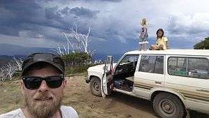
 Watching a storm roll in over the Upper Murray River catchment area, from Mount Gibbo. Photo by Leigh Blackall | |
| Highest point | |
| Elevation | 1,757 metres (5,764 ft) AHD [1] |
| Coordinates | 36°36′42″S 147°57′43″E |
| Geography | |
| Parent range | Great Dividing Range |
References
- "Prominent summits above 1200 m (Mt Feathertop, Mt Howitt, Mt Buller)". Victorian Resources Online. Department of Primary Industries. Retrieved 22 January 2013.
- "Mount Gibbo". Place Name Search. Retrieved 25 June 2012.
- "Mount Gibbo Natural Features and Scenic Reserve". Parks Victoria. Retrieved 25 June 2012.
- "8424-1 Mount Gibbo". Victorian Resources Online. Department of Primary Industries. Retrieved 25 June 2012.
- VicRoads country street directory of Victoria (Map 51) (3 ed.). Noble Park, Victoria: Royal Automobile Club of Victoria. ISSN 1329-5284.
- "Zones - Map No 37" (PDF). Towong Planning Scheme. Department of Planning and Community Development. Retrieved 26 June 2012.
- "Occurrence Record: MEL:MEL1599494A". Atlas of Living Australia. Retrieved 25 June 2012.
- "Occurrence Record: MEL:MEL2185830A". Atlas of Living Australia. Retrieved 25 June 2012.
