Morrisville, Missouri
Morrisville is a city in Polk County, Missouri, United States. The population was 388 at the 2010 census. It is part of the Springfield, Missouri Metropolitan Statistical Area.
Morrisville, Missouri | |
|---|---|
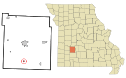 Location of Morrisville, Missouri | |
| Coordinates: 37°28′51″N 93°25′38″W | |
| Country | United States |
| State | Missouri |
| County | Polk |
| Area | |
| • Total | 0.64 sq mi (1.66 km2) |
| • Land | 0.64 sq mi (1.66 km2) |
| • Water | 0.00 sq mi (0.01 km2) |
| Elevation | 1,165 ft (355 m) |
| Population | |
| • Total | 388 |
| • Estimate (2019)[3] | 392 |
| • Density | 611.54/sq mi (236.28/km2) |
| Time zone | UTC-6 (Central (CST)) |
| • Summer (DST) | UTC-5 (CDT) |
| ZIP codes | 65645, 65710 |
| Area code(s) | 417 |
| FIPS code | 29-50078[4] |
| GNIS feature ID | 0735730[5] |
History
Morrisville was founded in 1870 by Morris Mitchell, and named after him.[6] A post office called Morrisville has been in operation since 1872.[7]
Geography
Morrisville is located at 37°28′51″N 93°25′38″W (37.480875, -93.427084).[8]
According to the United States Census Bureau, the city has a total area of 0.64 square miles (1.66 km2), all land.[9]
Demographics
| Historical population | |||
|---|---|---|---|
| Census | Pop. | %± | |
| 1880 | 122 | — | |
| 1910 | 360 | — | |
| 1920 | 425 | 18.1% | |
| 1930 | 340 | −20.0% | |
| 1940 | 329 | −3.2% | |
| 1950 | 296 | −10.0% | |
| 1960 | 228 | −23.0% | |
| 1970 | 256 | 12.3% | |
| 1980 | 331 | 29.3% | |
| 1990 | 293 | −11.5% | |
| 2000 | 344 | 17.4% | |
| 2010 | 388 | 12.8% | |
| Est. 2019 | 392 | [3] | 1.0% |
| U.S. Decennial Census[10] | |||
2010 census
As of the census[2] of 2010, there were 388 people, 153 households, and 110 families living in the city. The population density was 606.3 inhabitants per square mile (234.1/km2). There were 166 housing units at an average density of 259.4 per square mile (100.2/km2). The racial makeup of the city was 94.3% White, 1.0% African American, 0.8% Native American, 0.3% from other races, and 3.6% from two or more races. Hispanic or Latino of any race were 1.8% of the population.
There were 153 households, of which 34.0% had children under the age of 18 living with them, 55.6% were married couples living together, 9.2% had a female householder with no husband present, 7.2% had a male householder with no wife present, and 28.1% were non-families. 23.5% of all households were made up of individuals, and 8.5% had someone living alone who was 65 years of age or older. The average household size was 2.54 and the average family size was 2.97.
The median age in the city was 37.6 years. 24.7% of residents were under the age of 18; 10.1% were between the ages of 18 and 24; 24.1% were from 25 to 44; 27% were from 45 to 64; and 14.2% were 65 years of age or older. The gender makeup of the city was 50.3% male and 49.7% female.
2000 census
As of the census[4] of 2000, there were 344 people, 130 households, and 89 families living in the town. The population density was 1,125.5 people per square mile (428.4/km2). There were 137 housing units at an average density of 448.2 per square mile (170.6/km2). The racial makeup of the town was 98.84% White, 0.29% Native American, and 0.87% from two or more races. Hispanic or Latino of any race were 2.03% of the population.
There were 130 households, out of which 36.9% had children under the age of 18 living with them, 53.1% were married couples living together, 12.3% had a female householder with no husband present, and 30.8% were non-families. 27.7% of all households were made up of individuals, and 16.9% had someone living alone who was 65 years of age or older. The average household size was 2.65 and the average family size was 3.22.
In the town the population was spread out, with 29.9% under the age of 18, 8.1% from 18 to 24, 29.4% from 25 to 44, 17.2% from 45 to 64, and 15.4% who were 65 years of age or older. The median age was 36 years. For every 100 females, there were 96.6 males. For every 100 females age 18 and over, there were 89.8 males.
The median income for a household in the town was $23,906, and the median income for a family was $30,357. Males had a median income of $22,813 versus $20,556 for females. The per capita income for the town was $11,440. About 16.3% of families and 27.9% of the population were below the poverty line, including 27.0% of those under age 18 and 37.1% of those age 65 or over.
Education
Marion C. Early R-V School District operates one elementary school, one junior high school, and Marion C. Early High School at Morrisville.[11]
Morrisville has a public library, a branch of the Polk County Library.[12]
Notable person
Country singer Wynn Stewart was born in Morrisville.
References
- "2019 U.S. Gazetteer Files". United States Census Bureau. Retrieved July 26, 2020.
- "U.S. Census website". United States Census Bureau. Retrieved 2012-07-08.
- "Population and Housing Unit Estimates". United States Census Bureau. May 24, 2020. Retrieved May 27, 2020.
- "U.S. Census website". United States Census Bureau. Retrieved 2008-01-31.
- "US Board on Geographic Names". United States Geological Survey. 2007-10-25. Retrieved 2008-01-31.
- Eaton, David Wolfe (1917). How Missouri Counties, Towns and Streams Were Named. The State Historical Society of Missouri. pp. 343.
- "Post Offices". Jim Forte Postal History. Retrieved 10 December 2016.
- "US Gazetteer files: 2010, 2000, and 1990". United States Census Bureau. 2011-02-12. Retrieved 2011-04-23.
- "US Gazetteer files 2010". United States Census Bureau. Archived from the original on 2012-01-25. Retrieved 2012-07-08.
- "Census of Population and Housing". Census.gov. Retrieved June 4, 2015.
- "Marion C. Early R-V School District". Great Schools. Retrieved 18 March 2018.
- "About us". Polk County Library. Archived from the original on 18 March 2018. Retrieved 18 March 2018.
External links
- Historic maps of Morrisville in the Sanborn Maps of Missouri Collection at the University of Missouri
Municipalities and communities of Polk County, Missouri, United States | ||
|---|---|---|
| Cities | 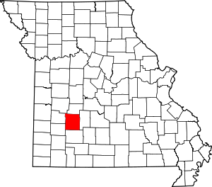 Map of Missouri highlighting Polk County | |
| Villages | ||
| Townships | ||
| Unincorporated communities | ||
| Ghost towns | ||
| Authority control |
|---|