Morolo
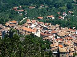
Morolo (locally Murolu) is a comune (municipality) in the Province of Frosinone in the Italian region Lazio, located about 70 kilometres (43 mi) southeast of Rome and about 12 kilometres (7 mi) west of Frosinone.
Morolo | |
|---|---|
| Comune di Morolo | |
 | |
Location of Morolo 
| |
 Morolo Location of Morolo in Italy  Morolo Morolo (Lazio) | |
| Coordinates: 41°38′N 13°12′E | |
| Country | Italy |
| Region | Lazio |
| Province | Frosinone (FR) |
| Government | |
| • Mayor | Gino Molinari |
| Area | |
| • Total | 26.5 km2 (10.2 sq mi) |
| Elevation | 397 m (1,302 ft) |
| Population (31 December 2010)[2] | |
| • Total | 3,299 |
| • Density | 120/km2 (320/sq mi) |
| Demonym(s) | Morolani |
| Time zone | UTC+1 (CET) |
| • Summer (DST) | UTC+2 (CEST) |
| Postal code | 03017 |
| Dialing code | 0775 |
| Patron saint | St. Michael Archangel |
| Website | Official website |
Morolo borders the following municipalities: Ferentino, Gorga, Sgurgola, Supino.
People
Sister cities
gollark: If you do, the kinetic augment will activate and fly you around wildly.
gollark: No you can't.
gollark: What is the problem with that?
gollark: It does yes.
gollark: I'll just disable your sense of smell then.
References
- "Superficie di Comuni Province e Regioni italiane al 9 ottobre 2011". Istat. Retrieved 16 March 2019.
- All demographics and other statistics: Italian statistical institute Istat.
External links
This article is issued from Wikipedia. The text is licensed under Creative Commons - Attribution - Sharealike. Additional terms may apply for the media files.