Morley Drive
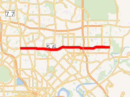
Morley Drive is a major east-west road in the inner northern suburbs of Perth, Western Australia, connecting the residential areas of Balcatta, Osborne Park, Tuart Hill, Nollamara, Yokine, Dianella, and Morley with major North-South arterial roads including Wanneroo Road, Alexander Drive, and Tonkin Highway. The road is part of State Route 76, which connects the coastal suburb of Trigg, Western Australia, with the Swan Valley in the east.[1] Morley Drive runs through the following local government areas city of Stirling, City of Bayswater and City of Swan
Morley Drive | |
|---|---|
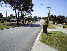 | |
View east from Dianella | |
| |
| General information | |
| Type | Highway |
| Length | 8.6 km (5.3 mi) |
| Route number(s) | |
| Major junctions | |
| West end | Main Street, Balcatta |
| |
| East end | |
| Location(s) | |
| Major suburbs | Nollamara, Dianella |
| Highway system | |
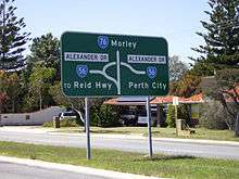
Morley Drive intersects Alexander Drive and The Strand at a hamburger roundabout, and Tonkin Highway as a roundabout interchange.[1]
Morley Drive is controlled by Main Roads Western Australia for its entire length, and is designated as part of the Karrinyup-Morley Highway (H28).[2]
Major intersections
| LGA | Location | km | mi | Destinations | Notes |
|---|---|---|---|---|---|
| Stirling | Balcatta, Tuart Hill | 0 | 0.0 | Main Street – Balcatta,Osborne Park | Morley Drive western terminus: continues as Karrinyup Road (State Route 76) |
| Balcatta, Nollamara, Yokine, Tuart Hill | 0.9 | 0.56 | |||
| Nollamara, Yokine | 2.0 | 1.2 | Flinders Street – Nollamara, Yokine | ||
| Dianella | 3.2 | 2.0 | Dianella Drive north – Dianella,Mirrabooka | Traffic light controlled T Junction | |
| 33 | 21 | Traffic light controlled T Junction | |||
| 4.1– 4.2 | 2.5– 2.6 | Hamburger roundabout: Morley Drive continues through roundabout | |||
| Stirling, Bayswater | Dianella, Morley | 5.8 | 3.6 | Camboon Road north / Wellington Road south-east – Dianella, Morley,Noranda | |
| Bayswater | Morley | 7.3 | 4.5 | Crimea Street – Morley, Noranda | |
| 8.6 | 5.3 | Morley Drive eastern terminus: continues as Morley Drive East (State Route 76). Roundabout interchange favouring Tonkin Highway. | |||
| 1.000 mi = 1.609 km; 1.000 km = 0.621 mi Note: Intersections with minor local roads are not shown | |||||
See also
![]()
References
- Department of Land Information. StreetSmart Perth Street Directory (54th ed.). West Australian Newspapers Ltd. pp. Maps 310-315. ISBN 978-0-909439-67-5.
- "Main Roads Metropolitan Road Fact Sheet" (PDF). Main Roads. 1 February 2011. Retrieved 11 June 2012.
| |||
| National Highways | |||
| National Routes | |||
| State Routes | |||
| Tourist Drives |
| ||