Monte Beigua
Monte Beigua (also in Ligurian: Monte Peigoa) is a mountain in the Ligurian Apennines in Liguria, northern Italy, between the two communes of Varazze and Sassello.
| Monte Beigua | |
|---|---|
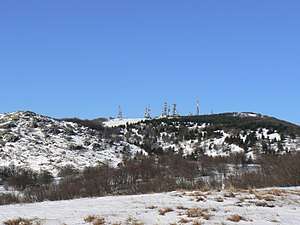 The peak of Mount Beigua | |
| Highest point | |
| Elevation | 1,287 m (4,222 ft) [1] |
| Prominence | 815 [1][2] |
| Coordinates | 44°26′00″N 08°33′55″E |
| Geography | |
| Parent range | Ligurian Apennines |
| Climbing | |
| First ascent | ancestral |
Geography
The mountain, at 1,287 m, is the highest peak in the so-called Gruppo del Beigua including Monte Grosso (1,265 m), Monte Ermetta (1,267 m) and Bric Veciri (1,263). The upper part of the mount houses transmission antennas used by RAI (Italian state television) and other private networks.
History
It has been hypothized that it was a sacred mountain to the Liguri tribe living here in pre-Roman times, together with the Mont Bégo and Monte Sagro.
Nature conservation
It is included in the eponymous Regional Park.[3]
gollark: Oh, so you're saying I should think of it like some weird mental health issue where they are unable to critically evaluate doing stuff with them?
gollark: They aren't going to experience horrible consequences if they don't.
gollark: But they're *choosing* to do whatever you say for their own bizarre reasons.
gollark: Generally we'd call it a "position of power" if they are actually able to do bad things of some sort to you i.e. fire you, harm you socially, whatever else.
gollark: Which I don't think actually works here?
References
- Monte Beigua, Italy, on www.peakbagger.com (access: July 2015)
- Key col:472 m
- Parco Naturale Regional del Beigua (in Italian, English, German, and French)
This article is issued from Wikipedia. The text is licensed under Creative Commons - Attribution - Sharealike. Additional terms may apply for the media files.