Montagudet
Montagudet is a commune in the Tarn-et-Garonne department in the Occitanie region in southern France.
Montagudet | |
|---|---|
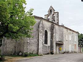 The church of Saint-Sulpice-de-Bourges, in Montagudet | |
Location of Montagudet 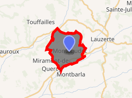
| |
 Montagudet  Montagudet | |
| Coordinates: 44°14′42″N 1°05′32″E | |
| Country | France |
| Region | Occitanie |
| Department | Tarn-et-Garonne |
| Arrondissement | Castelsarrasin |
| Canton | Pays de Serres Sud-Quercy |
| Intercommunality | Quercy Pays de Serres |
| Government | |
| • Mayor (2001–2008) | Jean Benois |
| Area 1 | 12.18 km2 (4.70 sq mi) |
| Population (2017-01-01)[1] | 197 |
| • Density | 16/km2 (42/sq mi) |
| Time zone | UTC+01:00 (CET) |
| • Summer (DST) | UTC+02:00 (CEST) |
| INSEE/Postal code | 82116 /82110 |
| Elevation | 91–237 m (299–778 ft) (avg. 200 m or 660 ft) |
| 1 French Land Register data, which excludes lakes, ponds, glaciers > 1 km2 (0.386 sq mi or 247 acres) and river estuaries. | |
Geography
The Séoune forms part of the commune's northern border. The Barguelonnette forms most of the commune's southern border.
gollark: Dan just said it had to be a very hard problem which is also hard to understand for laymen with an answer of 1.
gollark: I see.
gollark: Is this in the right order? There's nothing between the integral sign and the dx.
gollark: But that would take an unreasonably large amount of space to express.
gollark: Oh no.
References
- "Populations légales 2017". INSEE. Retrieved 6 January 2020.
| Wikimedia Commons has media related to Montagudet. |
| Authority control |
|
|---|
This article is issued from Wikipedia. The text is licensed under Creative Commons - Attribution - Sharealike. Additional terms may apply for the media files.