Arrondissement of Castelsarrasin
The arrondissement of Castelsarrasin is an arrondissement of France in the Tarn-et-Garonne department in the Occitanie region. It has 103 communes.[1] Its population is 77,423 (2016), and its area is 1,601.5 km2 (618.3 sq mi).[2]
Castelsarrasin | |
|---|---|
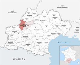 Location within the region Occitanie | |
| Country | France |
| Region | Occitanie |
| Department | Tarn-et-Garonne |
| No. of communes | 103 |
| Subprefecture | Castelsarrasin |
| Area | |
| • Total | 1,601.5 km2 (618.3 sq mi) |
| Population (2016) | |
| • Total | 77,423 |
| • Density | 48/km2 (120/sq mi) |
| INSEE code | 821 |
Composition
The communes of the arrondissement of Castelsarrasin, and their INSEE codes, are:[1]
- Albefeuille-Lagarde (82001)
- Angeville (82003)
- Asques (82004)
- Auterive (82006)
- Auvillar (82008)
- Balignac (82009)
- Bardigues (82010)
- Barry-d'Islemade (82011)
- Les Barthes (82012)
- Beaumont-de-Lomagne (82013)
- Belbèze-en-Lomagne (82015)
- Belvèze (82016)
- Boudou (82019)
- Bouloc-en-Quercy (82021)
- Bourg-de-Visa (82022)
- Brassac (82024)
- Castelferrus (82030)
- Castelmayran (82031)
- Castelsagrat (82032)
- Castelsarrasin (82033)
- Castéra-Bouzet (82034)
- Caumont (82035)
- Le Causé (82036)
- Cazes-Mondenard (82042)
- Cordes-Tolosannes (82045)
- Coutures (82046)
- Cumont (82047)
- Donzac (82049)
- Dunes (82050)
- Durfort-Lacapelette (82051)
- Escazeaux (82053)
- Espalais (82054)
- Esparsac (82055)
- Fajolles (82058)
- Faudoas (82059)
- Fauroux (82060)
- Garganvillar (82063)
- Gariès (82064)
- Gasques (82065)
- Gensac (82067)
- Gimat (82068)
- Glatens (82070)
- Goas (82071)
- Golfech (82072)
- Goudourville (82073)
- Gramont (82074)
- Labastide-du-Temple (82080)
- Labourgade (82081)
- Lachapelle (82083)
- Lacour (82084)
- Lafitte (82086)
- Lamagistère (82089)
- Lamothe-Cumont (82091)
- Larrazet (82093)
- Lauzerte (82094)
- Lavit (82097)
- Lizac (82099)
- Malause (82101)
- Mansonville (82102)
- Marignac (82103)
- Marsac (82104)
- Maubec (82106)
- Maumusson (82107)
- Meauzac (82108)
- Merles (82109)
- Miramont-de-Quercy (82111)
- Moissac (82112)
- Montagudet (82116)
- Montaigu-de-Quercy (82117)
- Montaïn (82118)
- Montbarla (82122)
- Montesquieu (82127)
- Montgaillard (82129)
- Montjoi (82130)
- Perville (82138)
- Le Pin (82139)
- Pommevic (82141)
- Poupas (82143)
- Puygaillard-de-Lomagne (82146)
- Roquecor (82151)
- Saint-Aignan (82152)
- Saint-Amans-de-Pellagal (82154)
- Saint-Amans-du-Pech (82153)
- Saint-Arroumex (82156)
- Saint-Beauzeil (82157)
- Saint-Cirice (82158)
- Saint-Clair (82160)
- Sainte-Juliette (82164)
- Saint-Jean-du-Bouzet (82163)
- Saint-Loup (82165)
- Saint-Michel (82166)
- Saint-Nazaire-de-Valentane (82168)
- Saint-Nicolas-de-la-Grave (82169)
- Saint-Paul-d'Espis (82170)
- Saint-Vincent-Lespinasse (82175)
- Sauveterre (82177)
- Sérignac (82180)
- Sistels (82181)
- Touffailles (82182)
- Tréjouls (82183)
- Valeilles (82185)
- Valence (82186)
- Vigueron (82193)
History
The arrondissement of Castelsarrasin was created in 1800 as part of the department Haute-Garonne.[3] It became part of the new department Tarn-et-Garonne in 1808.[4]
As a result of the reorganisation of the cantons of France which came into effect in 2015, the borders of the cantons are no longer related to the borders of the arrondissements. The cantons of the arrondissement of Castelsarrasin were, as of January 2015:[5]
gollark: The illogic causality nullifier array. Can you read?
gollark: ... no.
gollark: However, ██████ Siri predates EndOS and is believed to have originated from a ██████ project.
gollark: It also has the same amount of letters as potato.
gollark: ██████ Siri is believed to have been contained following extensive effort by all ███ █████ admins, although countermeasures are still in place within potatOS. Further, SPUDNET is not associated with Siri and use of it is safe.
References
- "Arrondissement de Castelsarrasin (821)". INSEE. Retrieved 2019-10-04.
- "Comparateur de territoire, géographie au 01/01/2019". INSEE. Retrieved 2019-10-04.
- Historique de la Haute-Garonne
- Historique de Tarn-et-Garonne
- "Populations légales 2012" (PDF). INSEE. December 2014. Retrieved 2019-10-07.
This article is issued from Wikipedia. The text is licensed under Creative Commons - Attribution - Sharealike. Additional terms may apply for the media files.