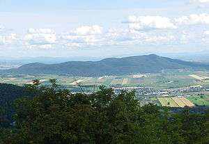
Mont Rougemont
Mont Rougemont (Abenaki: Wigwômedenek[1]) is part of the Monteregian Hills in southern Quebec. It is composed of igneous rock and hornfels. The summit stands 366 m (1,201 ft) above sea level. The mountain is mostly covered with sugar maple-dominated forest. Apple orchards and vineyards are cultivated on many of the lower slopes, and much of the fruit is used to make cider.
| Mont Rougemont Wigwômedenek | |
|---|---|
 | |
| Highest point | |
| Elevation | 390 m (1,280 ft) |
| Coordinates | 45°28′36″N 73°03′17″W |
| Geography | |
| Location | Rougemont, 18 kilometres southwest of Saint-Hyacinthe, Quebec, Canada |
| Parent range | Monteregian Hills |
| Topo map | NTS 031H/06 |
| Geology | |
| Age of rock | Early Cretaceous |
| Mountain type | Intrusive stock |
Geology
The igneous material is composed almost entirely of mafic and ultramafic rock such as gabbro and olivine-bearing pyroxenite. Mont Rougemont might be the deep extension of a vastly eroded ancient volcanic complex, which was probably active about 125 million years ago.[2] The mountain was created when the North American Plate moved westward over the New England hotspot,[2] along with the other mountains of the Monteregian Hills. It forms part of the vast Great Meteor hotspot track.
External links
- (in French) Ass. pour la protection et le développement durable du mont Rougemont (APDDMR)
- (in French) Nature Action Quebec
- (in French) Quebec in photographs Montérégie
References
- (PDF) http://www.rougemont.ca/upload/rougemont/editor/asset/1-%20%23%20%C3%89tienne%20Exupert%20de%20Rougemont.pdf. Retrieved 2017-09-24. Missing or empty
|title=(help) - A Hundred-Million Year History of the Corner Rise and New England Seamounts Archived 2006-05-03 at the Wayback Machine Retrieved on 2007-08-01