Močenok
Močenok (Hungarian: Mocsonok) is a village and municipality in Šaľa District, in the Nitra Region of south-west Slovakia.
Močenok | |
|---|---|
Municipality | |
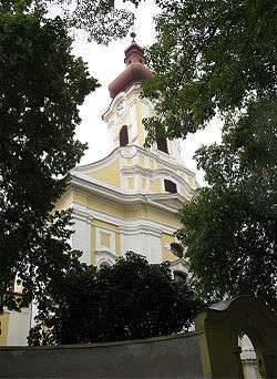
 Church of Saint Clement | |
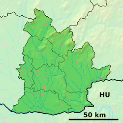
 Močenok Location of Močenok in the Nitra Region  Močenok Location of Močenok nad Žitavou in Slovakia | |
| Coordinates: 48°14′N 17°56′E | |
| Country | |
| Region | Nitra |
| District | Šaľa |
| First mentioned | 1113 |
| Area | |
| • Total | 46.39 km2 (17.91 sq mi) |
| Elevation | 141 m (463 ft) |
| Population | |
| • Total | 4,289 |
| • Density | 92/km2 (240/sq mi) |
| Time zone | UTC+1 (CET) |
| • Summer (DST) | UTC+2 (CEST) |
| Postal code | 951 31 |
| Area code(s) | 421-37 |
| Car plate | SA |
| Website | mocenok.sk |
Names and etymology
The name is derived from Slavic mučeník – a martyr and is probably related to the cult of Saint Clement of Rome (a patron of the local church) whose relics were brought through Great Moravia to the Rome by Saint Cyril.[1] The village was renamed to Mučníky in 1948, to Sládečkovce in 1951 (after a victim of a farmer strike from 1922) and returned to the original name in 1992.[2]
History
In historical records the village was first mentioned in 1113.
Geography
The village lies at an altitude of 141 metres and covers an area of 46.39 km². It has a population of about 4289 people.(31.12.2015)
Facilities
The village has a pharmacy, a public library a gym and a football pitch. It also has a cinema.
References
- Stanislav, Ján (2004). Slovenský juh v stredoveku II (in Slovak). Slovenské literárne centrum. p. 297. ISBN 80-88878-89-6.
- "Názov obce". Močenok - informačný portál obce (in Slovak). The municipality of Močenok. 14 July 2015. Retrieved 27 December 2016.
External links

- Official website

- http://www.statistics.sk/mosmis/eng/run.html