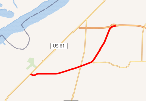
Mississippi Highway 713
Mississippi Highway 713 (MS 713) is a spur route in northwestern Mississippi that carries traffic between the relocated MS 304 and U.S. Route 61 (US 61), serving as a bypass of the northern section of Tunica Resorts for traffic headed to the Casino Strip Resorts, the town of Tunica, and destinations further south along US 61.
| |
|---|---|

| |
| Route information | |
| Maintained by MDOT | |
| Length | 7.085 mi[1] (11.402 km) |
| Major junctions | |
| South end | |
| North end | |
| Location | |
| Counties | DeSoto, Tunica |
| Highway system | |
History
The northern portion of MS 713 runs mostly north–south, coinciding with Interstate 69 (I-69) and is a freeway constructed to Interstate highway standards; it opened to traffic December 18, 2006.[2] The remainder of the route replaces the former route of MS 304 between U.S. 61 and Banks, Mississippi, is a five-lane undivided highway with a center turn lane, and runs east–west.
The portion of MS 713 in Tunica County was designated as the Martin Luther King, Jr., Memorial Highway by the Mississippi Legislature in 2003.[3]
Major intersections
| County | Location | mi[4] | km | Destinations | Notes |
|---|---|---|---|---|---|
| Tunica | Tunica Resorts | 0.0 | 0.0 | Southern terminus | |
| Banks | 4.0 | 6.4 | |||
| | 4.9 | 7.9 | Western terminus of MS 304 Scenic | ||
| | 5.2 | 8.4 | Southern end of I-69 overlap | ||
| DeSoto | | 8.3 | 13.4 | Northern terminus of MS 713, end overlap with I-69 | |
| 1.000 mi = 1.609 km; 1.000 km = 0.621 mi | |||||
References
- Mississippi Department of Transportation, "Mississippi Public Roads Selected Statistics Extent, Travel, and Designation", retrieved 4 September 2007. Archived February 5, 2007, at the Wayback Machine
- Highway 713 to Open to Traffic on Monday Archived 2007-09-28 at the Wayback Machine, December 14, 2006.
- "HB1419". state.ms.us.
- Google (December 7, 2012). "Mississippi Highway 713" (Map). Google Maps. Google. Retrieved December 7, 2012.
