Milson, New Zealand
Milson is a suburb of Palmerston North, Manawatū-Whanganui, New Zealand. The suburb is located to the north of the city, beyond the North Island Main Trunk Rail.
Milson | |
|---|---|
Suburb of Palmerston North | |
 Milson | |
| Coordinates: 40°19′S 175°36′E | |
| Country | New Zealand |
| Region | Manawatū-Whanganui region |
| Territorial authority | Palmerston North |
| Ward | Papaioea |
| Population (2001) | |
| • Total | 5,208 |
| Postcode | 4414 |
| Telephone | 06 |
Milson is mostly a residential suburb with a population of 5,208 (2001).[1] Milson is divided into a residential zone in the west and central and an industrial zone in the east.
Palmerston North Airport is in Milson.
Milson was part of the Papaioea Ward of Palmerston North City Council until 2013. It was part of the Manawatu electorate until 1996, when it became part of the Rangitikei electorate.
Many other local streets and parks have a space or US presidential theme. For example, Apollo Park has a spaced-themed playground and a butterfly park.[2] Other parks include Colquhoun Park, John F Kennedy Park, Clearview Park, Kennedy Park, Paradise Park, Pinedale Reserve, Langley Reserve, Clearview Reserve, Jefferson Reserve and Mangaone Stream Esplanade Reserve.[3]
History
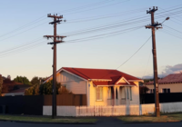
In 1926, work began on the nearby Milson railway deviation which was to take the main trunk line out of the city centre. Earlier in the decade, the Railways Department was granted their own housing programme to combat problems in housing its workers. To service the construction of the Milson deviation, the department planned and erected a settlement - founding Milson. Some 70 railway houses were built, and Milson Primary School and a community centre were built soon after.[4] With the neo-liberalisation of the railways in the late 20th century, many of these houses were privatised. Today, about 60 houses remain.
Much of the rest of the suburb was constructed after the 1950s.
Education
Milson School is a co-educational contributing state primary school for Year 1 to 6 students,[5][6] with a roll of 337 as of March 2020.[7]
St Peter's College is a co-educational state-integrated Catholic school for Year 7 to 13 students,[8][9] with a roll of 685 as of March 2020.[10]
References
- "Archived copy". Archived from the original on 2005-12-27. Retrieved 2006-09-04.CS1 maint: archived copy as title (link)
- "Five of Manawatū's top playgrounds". ManawatuNZ.com. Central Economic Development Agency.
- "Parks and Reserves - Milson". pncc.govt.nz. Palmerston North City Council.
- Roche, Michael. "Garden suburbs and NZ railways 1922 – 1929" (PDF). New Zealand Planning Institute.
- "Milson School Official School Website". milson.school.nz.
- "Milson School Ministry of Education School Profile". educationcounts.govt.nz. Ministry of Education.
- "Milson School Education Review Office Report". ero.govt.nz. Education Review Office.
- "St Peter's College Official School Website". stpeterspn.school.nz.
- "St Peter's College Ministry of Education School Profile". educationcounts.govt.nz. Ministry of Education.
- "St Peter's College Education Review Office Report". ero.govt.nz. Education Review Office.