Melbourne tram route 75
Melbourne tram route 75 is operated by Yarra Trams on the Melbourne tram network. It operates from Vermont South to Central Pier, Docklands, serviced by A and B class trams from Camberwell depot.[1][2] At 22.8 kilometres, it is currently the longest line in the network.[3][4]
| Route 75 | |||||
|---|---|---|---|---|---|
| Vermont South – Central Pier | |||||
 | |||||
_in_Flinders_St_on_route_75%2C_February_2009.jpg) | |||||
| Overview | |||||
| System | Melbourne | ||||
| Operator | Yarra Trams | ||||
| Depot | Camberwell | ||||
| Vehicle | A Class B2 Class | ||||
| Night-time | Friday & Saturday | ||||
| Route | |||||
| Locale | Melbourne, Australia | ||||
| Start | Vermont South Shopping Centre | ||||
| Via | Burwood (Burwood Highway) Camberwell (Camberwell Road) Hawthorn (Riversdale Road) Richmond (Bridge Road) City (Flinders Street) | ||||
| End | Central Pier, Docklands | ||||
| Length | 22.8 km (14.2 mi) | ||||
| Service | |||||
| Journey time | 60–85 minutes | ||||
| Operates | Daily | ||||
| Zone(s) | Free Zone: Stops D2-D6, 1–8 Myki Zone 1: Stops 9–40 Zone 1/2 overlap: Stops 41–75 | ||||
| Annual patronage | 9.3 million | ||||
| Timetable | Route 75 timetable and map | ||||
| |||||
History

The origins of route 75 lie in separate tram lines, Australia's first cable tram from Bourke Street to Hawthorn Bridge and a horse tram from Hawthorn Bridge to Auburn Road, which was converted to an electric line and extended over many years to its current terminus at Vermont South.
The first cable tram line opened by the Melbourne Tramway & Omnibus Company was from Bourke Street to Hawthorn Bridge along Spencer Street, Flinders Street, Wellington Parade and Bridge Road opened on 11 November 1885.[5][6] On 27 January 1889 a horse tram from Hawthorn Bridge to Auburn Road, travelling Burwood Road, Power Street and Riversdale Road was opened.
The Hawthorn Tramways Trust closed the horse tramway for conversion to electric traction on 31 January 1916, with the electric line opening in two stages; Power Street to Auburn Road along Riversdale Road opening on 7 May 1916, and from Hawthorn Bridge to Riversdale Road along Burwood Road and Power Street on 21 June 1916.
The Riversdale Road line was extended by the Hawthorn Tramways Trust to Bowen Street, Camberwell along Riversdale Road and Camberwell Road, passing through Camberwell Junction, opening on 31 May 1916, it was extended again to Boundary Road (now Warrigal Road) along Camberwell Road and Norwood Road (now Toorak Road) on 10 June 1916.[7]
The Melbourne & Metropolitan Tramways Board (MMTB) converted the Bourke Street to Hawthorn Bridge cable line to electric traction in three stages, closing the line on 29 June 1927. Reopening with electric trams running from Lonsdale Street, a short electric extension to the previous cable terminus of Bourke Street, to Swanston Street on 14 July 1927, from Swanston Street to Simpson Street on 17 September 1927, and Simpson Street to Hawthorn Bridge on 4 December 1927.[8]
The lines City terminus was extended slightly north to terminate at La Trobe Street, when the MMTB opened the La Trobe Street line on 15 January 1951.[9]
On 19 July 1978, the route was extended 3.4 kilometres from Warrigal Road to Middleborough Road, Burwood East,[10][11][12][13] on 8 July 1993 to Blackburn Road,[14][15] and on 25 July 2005 to its current terminus at Vermont South.[16][17][18]
During the 1999 election campaign, the State Opposition committed to extend route 75 to Knox City Shopping Centre. However the line was only extended to Vermont South with a connecting route 732 bus operated by Ventura Bus Lines.[19] The Public Transport Users Association has campaigned for the line to be extended to its originally proposed terminus.[20]
On 26 January 2014, the tram was permanently changed to the Docklands precinct, terminating at Central Pier Docklands and no longer serving Spencer Street.[21][22] In January 2016, route 75 began operating through the night on Fridays and Saturdays as part of the Night Network.[23]
| Dates | Route | Notes |
|---|---|---|
| 9 December 1934 – 12 February 1965 | Hartwell to City (Batman Avenue) | |
| 12 February 1965 – 18 July 1978 | Hartwell to City (Lonsdale/Spencer Street) | via Flinders Street |
| 19 July 1978 – 7 July 1993 | East Burwood (Middleborough Road) to City (Lonsdale/Spencer Street) | via Flinders Street |
| 8 July 1993 – Dec 1993 | East Burwood (Blackburn Road) to City (Lonsdale/Spencer Street) | via Flinders Street |
| Dec 1993 – 24 July 2005 | East Burwood (Blackburn Road) to City (La Trobe/Spencer Street) | via Flinders Street |
| 25 July 2005 – 25 January 2014 | Vermont South to City (La Trobe/Spencer Street) | via Flinders Street |
| 26 July 2014 – onwards | Vermont South to Etihad Stadium Docklands | via Flinders Street and Harbour Esplanade |
Route
Description
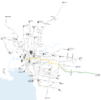
Route 75 runs Central Pier Docklands along Flinders Street and continues past Flinders Street station, St Paul's Cathedral, and Federation Square, entering East Melbourne east along Wellington Parade and into Richmond continuing east on Bridge Road.
At Hawthorn Bridge it crosses the Yarra River into Hawthorn and continues east on Burwood Road, it briefly travels south on Power Street before turning east into Riversdale Road, traversing Hawthorn and Hawthorn East. At Camberwell Junction it crosses Burke Road and travels south east along Camberwell Road.
It enters Toorak Road and heads east, at Warrigal Road Toorak Road becomes the Burwood Highway, it continues east, past Deakin University and through Burwood East, to its terminus in Vermont South.[19]
Operation
Route 75 is run from Camberwell depot[24] and is predominantly run with B class trams, although A class trams are occasionally used. During the Australian Open, almost all services are run with A-class trams.
Controversy over accessibility

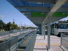
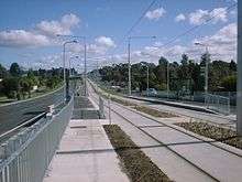
During the extension of the route from Burwood to Vermont South, all new stops were constructed as wheelchair accessible, low-floor platforms, with many other stops along the route converted to accessible platforms.[25]
There has been controversy in the local newspaper, as even though the platforms are wheelchair accessible, the route is operated with high floor trams with steps.[26] The upgrade has been criticised as a waste of money, because passengers using wheelchairs and other mobility-impaired passengers are still limited from accessing trams on the route.
Route map
Route 75 | ||||||||||||||||||||||||||||||||||||||||||||||||||||||||||||||||||||||||||||||||||||||||||||||||||||||||||||||||||||||||||||||||||||||||||||||||||||||||||||||||||||||||||||||||||||||||||||||||||||||||||||||||||||||||||||||||||||||||||||||||||||||||||||||||||||||||||||||||||||||||||||||||||||||||||||||||||||||||||||||||||||||||||||||||||||||||||||||||||||||||||||||||||||||||||||||||||||||||||||||||||||||||||||||||||||||||||||||||||||||||||||||||||||||||||||||||||||||||||||||||||||||||||||||||||||||||||||||||||||||||||||||||||||||||||||||||||||||||||||||||||||||||||||||||||||||||||||||||||||||||||||||||||||||||||||||||||||||||||||||||||||||||||||||||||||||||||||||||||||||||||||||||||||||||||||||||||||||||||||||||||||||||||||||||||||||||||||||||||||||||||||||||||||
|---|---|---|---|---|---|---|---|---|---|---|---|---|---|---|---|---|---|---|---|---|---|---|---|---|---|---|---|---|---|---|---|---|---|---|---|---|---|---|---|---|---|---|---|---|---|---|---|---|---|---|---|---|---|---|---|---|---|---|---|---|---|---|---|---|---|---|---|---|---|---|---|---|---|---|---|---|---|---|---|---|---|---|---|---|---|---|---|---|---|---|---|---|---|---|---|---|---|---|---|---|---|---|---|---|---|---|---|---|---|---|---|---|---|---|---|---|---|---|---|---|---|---|---|---|---|---|---|---|---|---|---|---|---|---|---|---|---|---|---|---|---|---|---|---|---|---|---|---|---|---|---|---|---|---|---|---|---|---|---|---|---|---|---|---|---|---|---|---|---|---|---|---|---|---|---|---|---|---|---|---|---|---|---|---|---|---|---|---|---|---|---|---|---|---|---|---|---|---|---|---|---|---|---|---|---|---|---|---|---|---|---|---|---|---|---|---|---|---|---|---|---|---|---|---|---|---|---|---|---|---|---|---|---|---|---|---|---|---|---|---|---|---|---|---|---|---|---|---|---|---|---|---|---|---|---|---|---|---|---|---|---|---|---|---|---|---|---|---|---|---|---|---|---|---|---|---|---|---|---|---|---|---|---|---|---|---|---|---|---|---|---|---|---|---|---|---|---|---|---|---|---|---|---|---|---|---|---|---|---|---|---|---|---|---|---|---|---|---|---|---|---|---|---|---|---|---|---|---|---|---|---|---|---|---|---|---|---|---|---|---|---|---|---|---|---|---|---|---|---|---|---|---|---|---|---|---|---|---|---|---|---|---|---|---|---|---|---|---|---|---|---|---|---|---|---|---|---|---|---|---|---|---|---|---|---|---|---|---|---|---|---|---|---|---|---|---|---|---|---|---|---|---|---|---|---|---|---|---|---|---|---|---|---|---|---|---|---|---|---|---|---|---|---|---|---|---|---|---|---|---|---|---|---|---|---|---|---|---|---|---|---|---|---|---|---|---|---|---|---|---|---|---|---|---|---|---|---|---|---|---|---|---|---|---|---|---|---|---|---|---|---|---|---|---|---|---|---|---|---|---|---|---|---|---|---|---|---|---|---|---|---|---|---|---|---|---|---|---|---|---|---|---|---|---|---|---|---|---|---|---|---|---|---|---|---|---|---|---|---|---|---|---|---|---|---|---|---|---|---|---|---|---|---|---|---|---|---|---|---|---|---|---|---|---|---|---|---|---|---|---|---|---|---|---|---|---|---|---|---|---|---|---|---|---|---|---|---|---|---|---|---|---|---|---|---|---|---|---|---|---|---|---|---|---|---|---|---|---|---|---|---|---|---|---|---|---|---|---|---|---|---|---|---|---|---|---|---|---|---|---|---|---|---|---|---|---|---|---|---|---|---|---|---|---|---|---|---|---|---|---|---|---|---|---|---|---|---|---|---|---|---|---|---|---|---|---|---|---|---|---|---|---|---|---|---|---|---|---|---|---|---|---|---|---|---|---|---|---|---|---|---|---|---|---|---|---|---|---|---|---|---|---|---|---|---|---|---|---|---|---|---|---|---|---|---|---|---|---|---|---|---|---|---|---|---|---|---|---|---|---|---|---|---|---|---|---|---|---|---|---|---|---|---|---|---|---|---|---|---|---|---|---|---|---|---|---|---|---|---|---|---|---|---|---|---|---|---|---|---|---|---|---|---|---|---|---|---|---|---|---|---|---|---|---|---|---|---|---|---|---|---|---|
| Vermont South - Central Pier via Burwood, Hawthorn, Richmond & City Free tram zone covers stops D2 to 8, fare zone 1 applies from stop 9 to 75, fare zone 2 applies from stop 41 to 75 | ||||||||||||||||||||||||||||||||||||||||||||||||||||||||||||||||||||||||||||||||||||||||||||||||||||||||||||||||||||||||||||||||||||||||||||||||||||||||||||||||||||||||||||||||||||||||||||||||||||||||||||||||||||||||||||||||||||||||||||||||||||||||||||||||||||||||||||||||||||||||||||||||||||||||||||||||||||||||||||||||||||||||||||||||||||||||||||||||||||||||||||||||||||||||||||||||||||||||||||||||||||||||||||||||||||||||||||||||||||||||||||||||||||||||||||||||||||||||||||||||||||||||||||||||||||||||||||||||||||||||||||||||||||||||||||||||||||||||||||||||||||||||||||||||||||||||||||||||||||||||||||||||||||||||||||||||||||||||||||||||||||||||||||||||||||||||||||||||||||||||||||||||||||||||||||||||||||||||||||||||||||||||||||||||||||||||||||||||||||||||||||||||||||
| ||||||||||||||||||||||||||||||||||||||||||||||||||||||||||||||||||||||||||||||||||||||||||||||||||||||||||||||||||||||||||||||||||||||||||||||||||||||||||||||||||||||||||||||||||||||||||||||||||||||||||||||||||||||||||||||||||||||||||||||||||||||||||||||||||||||||||||||||||||||||||||||||||||||||||||||||||||||||||||||||||||||||||||||||||||||||||||||||||||||||||||||||||||||||||||||||||||||||||||||||||||||||||||||||||||||||||||||||||||||||||||||||||||||||||||||||||||||||||||||||||||||||||||||||||||||||||||||||||||||||||||||||||||||||||||||||||||||||||||||||||||||||||||||||||||||||||||||||||||||||||||||||||||||||||||||||||||||||||||||||||||||||||||||||||||||||||||||||||||||||||||||||||||||||||||||||||||||||||||||||||||||||||||||||||||||||||||||||||||||||||||||||||||
| Note: Green denotes free tram zone | ||||||||||||||||||||||||||||||||||||||||||||||||||||||||||||||||||||||||||||||||||||||||||||||||||||||||||||||||||||||||||||||||||||||||||||||||||||||||||||||||||||||||||||||||||||||||||||||||||||||||||||||||||||||||||||||||||||||||||||||||||||||||||||||||||||||||||||||||||||||||||||||||||||||||||||||||||||||||||||||||||||||||||||||||||||||||||||||||||||||||||||||||||||||||||||||||||||||||||||||||||||||||||||||||||||||||||||||||||||||||||||||||||||||||||||||||||||||||||||||||||||||||||||||||||||||||||||||||||||||||||||||||||||||||||||||||||||||||||||||||||||||||||||||||||||||||||||||||||||||||||||||||||||||||||||||||||||||||||||||||||||||||||||||||||||||||||||||||||||||||||||||||||||||||||||||||||||||||||||||||||||||||||||||||||||||||||||||||||||||||||||||||||||
References
- Facts & figures Archived 29 May 2014 at the Wayback Machine Yarra Trams
- Route 75 Yarra Trams
- Raj, Hari (16 May 2017). "www.theweeklyreview.com.au/live/jump-aboard-the-tram-routes-that-define-melbourne/". The Weekly Review. Retrieved 31 August 2017.
- Brown, Simon Leo (3 June 2016). "Election 2016: Track the views of voters along the 75 tram". ABC Radio Melbourne. Retrieved 31 August 2017.
- History of Trams in Melbourne, Yarra Trams, archived from the original on 29 September 2011, retrieved 10 October 2011
- Melbourne Tramway & Omnibus Company Limited Running Journal volume 9 no 3-page 16
- Milestones, 1911 – 1920, Yarra Trams, archived from the original on 27 September 2011, retrieved 10 October 2011
- Milestones, 1921 – 1930, Yarra Trams, archived from the original on 20 March 2012, retrieved 10 October 2011
- Milestones, 1951 – 1960, Yarra Trams, archived from the original on 20 March 2012, retrieved 28 September 2011
- "East Burwood opened" Trolley Wire issue 177 August 1978 page 25
- "In Brief" Railway Gazette International September 1978 page 637
- Jones, Colin (1993). Watch for Trams. Kenthurst: Kangaroo Press. p. 118. ISBN 0 86417 544 2.
- Milestones, 1971 – 1980, Yarra Trams, archived from the original on 14 April 2012, retrieved 28 September 2011
- "East Burwood Extension" Trolley Wire issue 254 August 1993 page 26
- Milestones, 1991 – 2000, Yarra Trams, archived from the original on 14 April 2012, retrieved 28 September 2011
- "Vermount South extension opens" Trolley Wire issue 304 February 2006 pages 18/19
- Milestones, 2001 – 2011, Yarra Trams, archived from the original on 20 March 2012, retrieved 28 September 2011
- History of Melbourne Trams Routes from 1950 to 2009 Archived 26 February 2017 at the Wayback Machine Yarra Trams
- "732 Box Hill - Upper Ferntree Gully via Vermont South & Knox City & Mountain Gate". Public Transport Victoria.
- "Submission to Infrastructure Australia on Victoria's transport infrastructure priorities" (PDF), Public Transport Users Association, p. 8, retrieved 3 November 2011
- New timetable delivers more than 1,200 extra trams to Docklands effective from Sunday 26 January Archived 18 March 2016 at the Wayback Machine Public Transport Victoria 10 January 2014
- Route 75 is on the move Yarra Trams 21 January 2014
- Night Tram Public Transport Victoria
- "Camberwell Depot", Vicsig, retrieved 10 October 2011
- Accessible tram stops on route 75, Yarra Trams, retrieved 29 January 2012
- Rebecca Thistleton (27 September 2011). "Bridge Road trams still stop disabled". Melbourne Times Weekly. Archived from the original on 4 September 2012. Retrieved 29 January 2012.
External links

- Route 75 timetable and map
