Masaki, Ehime
Masaki (Japanese: 松前町, Hepburn: Masaki-chō) is a town located in Iyo District, Ehime Prefecture, Japan.
Masaki 松前町 | |
|---|---|
Town | |
 Flag  Emblem | |
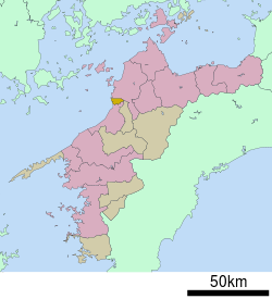 Location of Masaki in Ehime Prefecture | |
 Masaki Location in Japan | |
| Coordinates: 33°47′N 132°43′E | |
| Country | Japan |
| Region | Shikoku |
| Prefecture | Ehime Prefecture |
| District | Iyo |
| Government | |
| • Mayor | Yasushi Okamoto |
| Area | |
| • Total | 20.41 km2 (7.88 sq mi) |
| Population (April 1, 2017) | |
| • Total | 29,904 |
| • Density | 1,500/km2 (3,800/sq mi) |
| Symbols | |
| • Tree | Pine (松, Matsu) |
| • Flower | Sunflower (向日葵, Himawari) |
| Time zone | UTC+9 (JST) |
| City hall address | 6-3-1 Tsutsui, Masaki-chō, Iyo-gun, Ehime-ken 791-3192 |
| Website | www |
As of April 1, 2017, the town has an estimated population of 29,904 and a density of 1,500 persons per km². The total area is 20.41 km², the smallest in the prefecture.[1]
Education
Masaki currently contains three elementary schools, three junior high schools and a high school.
Transportation
Railways
- Iyotetsu
- Gunchū Line: Okada - Koizumi - Masaki - Jizomachi
- JR Shikoku
Highways
The Japan National Route 56 passes through Masaki.
Points of interest
gollark: Also, don't do alcohol, kids!
gollark: And then stop, I mean.
gollark: You build tolerance over time, and there are bad withdrawal symptoms if you take it for ages.
gollark: I mean, it's sort of bad.
gollark: YET.
References
- 松前町の面積が変わりました. Masaki's official website (in Japanese). 11 March 2015. Retrieved 14 September 2018.
External links

- Masaki official website (in Japanese)
Matsuyama (capital) | ||
| Core city | ||
| Cities |
| |
| Districts | ||
| Authority control |
|
|---|
This article is issued from Wikipedia. The text is licensed under Creative Commons - Attribution - Sharealike. Additional terms may apply for the media files.