Marseille–Ventimiglia railway
The railway from Marseille to Ventimiglia is a French and Italian 259-kilometre long railway line. It is used for passenger (express, regional and suburban) and freight traffic. The railway was opened in several stages between 1858 and 1872.[3]
| Marseille–Ventimiglia railway | |
|---|---|
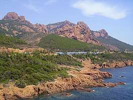
 The railway at Esterel Massif | |
| Overview | |
| System | SNCF |
| Status | Operational |
| Locale | France (Provence-Alpes-Côte d'Azur), Monaco, Italy (Liguria) |
| Termini | Marseille-Saint-Charles Ventimiglia |
| Operation | |
| Opened | 1858-1872 |
| Owner | RFF |
| Operator(s) | SNCF |
| Technical | |
| Line length | 259 km (161 mi) |
| Number of tracks | Double track[1] 4 tracks between Marseille St Charles and Marseille-Blancarde, 3 tracks between Marseille-Blancarde and Aubagne 3 tracks between Cannes and Nice |
| Track gauge | 1,435 mm (4 ft 8 1⁄2 in) standard gauge |
| Electrification | 25 kV AC[2] |
Main stations
- Marseille-Saint-Charles
- Toulon
- Les Arcs-Draguignan
- Fréjus
- Saint-Raphaël-Valescure
- Cannes
- Antibes
- Nice-Saint-Augustin
- Nice-Ville
- Monaco-Monte-Carlo
- Menton
- Ventimiglia
Line history
The Marseille–Ventimiglia railway was built and used by the Chemins de fer de Paris à Lyon et à la Méditerranée. The first section that was opened in 1858 led from Marseille to Aubagne. The line was extended to Toulon in 1859, and to Les Arcs in 1862. Cagnes-sur-Mer was reached in 1863, and Nice in 1864. The line was extended to Monaco in 1868, and to Menton in 1869.[3] Finally in 1872 the section from Menton to Ventimiglia was opened.
gollark: Hold on, I can probably make a much nicer one.
gollark: It's kind of bad.
gollark: ```python#!/bin/env python3chars = [chr(n) for n in range(126)]firstchar = chars[0]lastchar = chars[len(chars) - 1]def increment_char(character): return chr(ord(character) + 1)def old_increment_string(string_to_increment): reversed_string = list(reversed(string_to_increment)) # Reverse the string for easier work. for rindex, char in enumerate(reversed_string): if char == lastchar: # If we can't increment this char further, try the next ones. reversed_string[rindex] = firstchar # Set the current char back to the first one. reversed_string[rindex + 1] = increment_char(reversed_string[rindex + 1]) # Increment the next one along. else: # We only want to increment ONE char, unless we need to "carry". reversed_string[rindex] = increment_char(reversed_string[rindex]) break return ''.join(list(reversed(reversed_string)))def increment_string(to_increment): reversed_string = list(to_increment) # Reverse the string for easier work. for rindex, char in enumerate(reversed_string): if char == lastchar: # If we can't increment this char further, try the next ones. reversed_string[rindex] = firstchar # Set the current char back to the first one. reversed_string[rindex + 1] = increment_char(reversed_string[rindex + 1]) # Increment the next one along. else: # We only want to increment ONE char, unless we need to "carry". reversed_string[rindex] = increment_char(reversed_string[rindex]) break return ''.join(list(reversed_string))def string_generator(): length = 0 while 1: length += 1 string = chars[0] * length while True: try: string = increment_string(string) except IndexError: # Incrementing has gone out of the char array, move onto next length break yield string```
gollark: Except it enumerates all possible ASCII strings instead.
gollark: I made that!
References
- "RFF - Network map" (PDF). Archived from the original (PDF) on 2011-07-18.
- "RFF - Map of electrified railway lines" (PDF).
- Direction Générale des Ponts et Chaussées et des Chemins de Fer (1869). Statistique centrale des chemins de fer. Chemins de fer français. Situation au 31 décembre 1869 (in French). Paris: Ministère des Travaux Publics. pp. 146–160.
This article is issued from Wikipedia. The text is licensed under Creative Commons - Attribution - Sharealike. Additional terms may apply for the media files.