Le Cannet-des-Maures
Le Cannet-des-Maures is a commune in the Var department in the Provence-Alpes-Côte d'Azur region in southeastern France.
Le Cannet-des-Maures | |
|---|---|
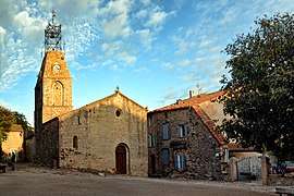 The church of Saint-Michel | |
.svg.png) Coat of arms | |
Location of Le Cannet-des-Maures 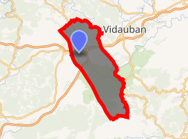
| |
 Le Cannet-des-Maures  Le Cannet-des-Maures | |
| Coordinates: 43°23′30″N 6°20′27″E | |
| Country | France |
| Region | Provence-Alpes-Côte d'Azur |
| Department | Var |
| Arrondissement | Brignoles |
| Canton | Le Luc |
| Intercommunality | Cœur du Var |
| Area 1 | 73.64 km2 (28.43 sq mi) |
| Population (2017-01-01)[1] | 4,300 |
| • Density | 58/km2 (150/sq mi) |
| Time zone | UTC+01:00 (CET) |
| • Summer (DST) | UTC+02:00 (CEST) |
| INSEE/Postal code | 83031 /83340 |
| Elevation | 52–628 m (171–2,060 ft) |
| 1 French Land Register data, which excludes lakes, ponds, glaciers > 1 km2 (0.386 sq mi or 247 acres) and river estuaries. | |
History
The town was called "Cannet" until the French Revolution, and later "Le Cannet". During world war II on 15 of June 1940, the airfield was attacked by 25 Italian fighters Fiat C.R.42s that strafed about 20 French aircraft destroying some of them.
gollark: You can use microG, an alternative FOSS implementation of some Google Play Services features, on some ROMs, *but* it can't do anything about SafetyNet because they have some cryptographic thing and do verification on the serverside somehow.
gollark: Google wasn't first to do search. Microsoft wasn't the first to... have an OS?
gollark: Not really.
gollark: If you *remove* those they can't do anything but also a bunch of apps probably break.
gollark: and/or still have them.
See also
External links
![]()
| Authority control |
|
|---|
This article is issued from Wikipedia. The text is licensed under Creative Commons - Attribution - Sharealike. Additional terms may apply for the media files.