Roya (river)
The Roya (French), Roia (Italian), or Ròia (Brigasc, Occitan) is a 59-kilometre (37 mi) river of France and Italy.
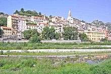
The Italian city of Ventimiglia on the French border and its river, the Roya.
| Roya, Roia, Roja | |
|---|---|
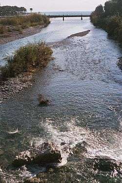 The river at Ventimiglia | |
.png) | |
| Location | |
| Country | France, Italy |
| Physical characteristics | |
| Source | |
| • location | Colle di Tenda near Tende, France. |
| • elevation | 1,908 m (6,260 ft) |
| Mouth | |
• location | Ligurian Sea at Ventimiglia, Italy |
• coordinates | 43°47′17″N 7°36′22″E |
• elevation | 0 m (0 ft) |
| Length | 59 km (37 mi) |
| Basin size | 660 km2 (250 sq mi) |
| Discharge | |
| • average | 15 m3/s (530 cu ft/s) |
River course
The river rises in French territory near the Col de Tende and flows through the Mercantour National Park The river passes through the communes of Tende, Saorge, Breil-sur-Roya, La Brigue, before entering Italy in the commune of Olivetta San Michele. The remainder of its course remains within the province of Imperia and, after crossing Airole the river enters the sea at Ventimiglia.[1]
Its main tributaries are the Lévensa, the Bévéra, the Bendola, the Réfréi and the Maglia.
gollark: Wait, no, 4.
gollark: Not for another, er, 7 hours.
gollark: https://dragcave.net/view/mRROCSo many good codes lost...
gollark: "Why 7 cat(s)?"
gollark: Alas, a good dragon and code, lost in the wilderness: https://dragcave.net/view/Y7CAt
References
![]()
- The Times (1985), Atlas of the World: Comprehensive Edition, Times Books, Plate 78 (C7).
This article is issued from Wikipedia. The text is licensed under Creative Commons - Attribution - Sharealike. Additional terms may apply for the media files.