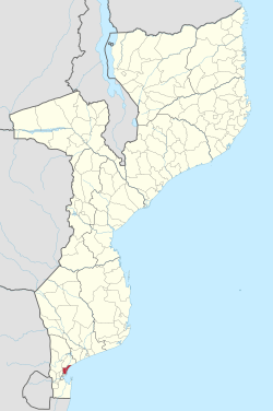
Marracuene District
Marracuene District is a district of Maputo Province in southern Mozambique. The principal town is Marracuene. The district is located in the center of the province, and borders with Manhiça District in the north, the city of Maputo in the south, and with the city of Matola and with Moamba District in the west. In the east, the district is limited by the Indian Ocean. The area of the district is 703 square kilometres (271 sq mi).[1] It has a population of 136,784 as of 2007.[2]
Marracuene | |
|---|---|
 Marracuene District on the map of Mozambique | |
| Country | Mozambique |
| Province | Maputo |
| Capital | Marracuene |
| Area | |
| • Total | 703 km2 (271 sq mi) |
| Population (2007 census) | |
| • Total | 136,784 |
| • Density | 190/km2 (500/sq mi) |
Geography
The principal river in the district is the Incomati River.[1]
The climate is tropical humid, with the annual rainfall ranging between 500 millimetres (20 in) and 1,000 millimetres (39 in).[1]
History
Marracuene, then known as Vila Luísa, served as a popular tourist destination in Mozambique's colonial era thanks to a 21-mile beach on the Indian Ocean; the town also served as a key link in the Lourenço Marques Railway System.
On February 2, 1895, Marracuene was the site of a decisive battle between Portuguese commander António José Enes and Ronga emperor Gungunyane; the Portuguese defeated the Ronga forces by means of repeating rifles and a machine gun.[1]
Demographics
As of 2005, 41% of the population of the district was younger than 15 years. 59% of the population spoke Portuguese. The most common mothertongue among the population was Varhonga. 48% were analphabetic, mostly women.[1]
Administrative divisions
The district is divided into two postos, Marracuene (three localities) and Machubo (two localities).[1]
Economy
2% of the households in the district have access to electricity.[1]
Agriculture
In the district, there are 10,000 farms with, on average, 1.1 hectares (0.0042 sq mi) of land. The main agricultural products are corn, cassava, cowpea, peanut, rice, and sweet potato.[1]
Transportation
There is a road network in the district, which includes 40 kilometres (25 mi) of the national road EN1, running from Maputo north along the coast.[1]
References
Notes
- "Perfil do Distrito de Marracuene" (PDF) (in Portuguese). Ministry of State Administration. 2005. Retrieved 30 October 2016.
- "População da Provincia de Maputo". Censo 2007 (in Portuguese). Instituto Nacional de Estatística. Archived from the original on 20 February 2008. Retrieved 20 March 2008.
Sources
- Hance, William A. and Irene S. Van Dongen. "Lourenço Marques in Delagoa Bay." Economic Geography 33.3 (1957): 238-256.
- Wheeler, Douglas L. "Gungunyane the Negotiator: A Study in African Diplomacy." The Journal of African History 9.4 (1968): 585-602.