Marlborough, Connecticut
Marlborough is a town in Hartford County, Connecticut, United States. It contains the census-designated place (CDP) of Terramuggus. The town's population was 6,404 at the 2010 census.[1] Marlborough is a middle class suburban and rural community. The local high school is RHAM High School. In 2013, Marlborough ranked third (of 24) in Connecticut Magazine's biannual ranking of Connecticut small towns, median home sale price between $175,000 and $224,999.[2] Educationally, RHAM High School, which serves Marlborough, Hebron, and Andover students, was the top-ranked regional high school in the state on the SAT in 2017, and 11th highest-performing school in the state on the test.[3]
Marlborough, Connecticut | |
|---|---|
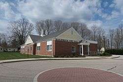 Town Hall | |
 Seal | |
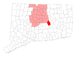 Location within Hartford County, Connecticut | |
| Coordinates: 41°38′07″N 72°29′14″W | |
| Country | |
| U.S. state | |
| County | Hartford |
| Metropolitan area | Hartford |
| Incorporated | 1803 |
| Government | |
| • Type | Selectman-town meeting |
| • First Selectman | Amy Traversa (D) |
| • Selectman | Richard A. Shea (R) |
| • Selectman | Evelyn Lee Godbout (D) |
| Area | |
| • Total | 23.5 sq mi (60.9 km2) |
| • Land | 23.4 sq mi (60.5 km2) |
| • Water | 0.2 sq mi (0.4 km2) |
| Elevation | 538 ft (164 m) |
| Population (2010) | |
| • Total | 6,404 |
| • Density | 270/sq mi (110/km2) |
| Time zone | UTC-5 (Eastern) |
| • Summer (DST) | UTC-4 (Eastern) |
| ZIP Code | 06447 |
| Area code(s) | 860 |
| FIPS code | 09-45820 |
| GNIS feature ID | 0213457 |
| Website | Town Website |
History
The earliest inhabitants of present-day Marlborough, prior to the arrival of the English settlers, were the Podunk people, an indigenous people who spoke an Algonquian language. The beginnings of the town can be traced back to the opening of (John) Sadler's Ordinary, a colonial-era rest stop, in 1648. It was the second such establishment in Connecticut Colony after Hartford. It was a crossroads of sorts during colonial times, and travelers would stop to rest at the heart of what is now Marlborough center at the Buell House (now the Marlborough Tavern). Although the original Sadler's Ordinary (Inn) eventually went out of business, a new Sadler's Ordinary was built in a new location in 1970, and is still in business today.[4]
In 1747, William Buell and Joel Foote petitioned the colonial General Court for permission to form an Ecclesiastical Society and settle what was to become known as the town of Marlborough. In 1749, they began constructing the First Congregational Church which wouldn’t be finished until 1803.[5] Marlborough was incorporated on 13 October 1803 with land from parts of three neighboring towns: Glastonbury, Colchester (New London County) and Hebron (Tolland County).[6][7] The town took its name from Marlborough, Massachusetts.[8]
By 1907 the town had a population of less than 305 residents. It wasn’t until the 1960s that the town was rediscovered as a bedroom community for white collar working in Hartford.[9] A complete town history called Reflections Into Marlborough's History was published in 2007.
Geography
According to the United States Census Bureau, the town has a total area of 23.5 square miles (60.9 km2), of which 23.4 square miles (60.5 km2) is land and 0.15 square miles (0.4 km2), or 0.73%, is water.[1] Marlborough is adjacent to four other Connecticut towns (Glastonbury to the north, East Hampton to the west, Colchester to the south, and Hebron to the east). East Hampton, Colchester and Hebron are each in different counties from each other and from Marlborough.
Route 2, a two-lane highway (sometimes three) in most sections, bisects the town, and there are three Marlborough exits, at South Main Street, Route 66, and West Road, although there are exits westbound only for South Main and eastbound only for West Road. It takes approximately 15– 20 minutes to get to Hartford, 40 minutes to New London, 45 minutes to New Haven, and 40 minutes to Springfield, MA. Marlborough is generally equidistant between Boston and New York. Boston is an hour and 45 minutes away, while New York City is a two-hour car ride, pending traffic conditions. Popular vacation areas are also reasonable drives from Marlborough. The Berkshire Mountains are an hour and 20 minutes away, and popular Rhode Island beaches, depending on which one you go to, are an hour (Misquamicut, Westerly) to an hour and 20 minutes away (Narragansett).
Demographics
| Historical population | |||
|---|---|---|---|
| Census | Pop. | %± | |
| 1820 | 1,954 | — | |
| 1850 | 832 | — | |
| 1860 | 682 | −18.0% | |
| 1870 | 476 | −30.2% | |
| 1880 | 391 | −17.9% | |
| 1890 | 582 | 48.8% | |
| 1900 | 322 | −44.7% | |
| 1910 | 302 | −6.2% | |
| 1920 | 303 | 0.3% | |
| 1930 | 319 | 5.3% | |
| 1940 | 476 | 49.2% | |
| 1950 | 901 | 89.3% | |
| 1960 | 1,961 | 117.6% | |
| 1970 | 2,991 | 52.5% | |
| 1980 | 4,746 | 58.7% | |
| 1990 | 5,535 | 16.6% | |
| 2000 | 5,709 | 3.1% | |
| 2010 | 6,404 | 12.2% | |
| Est. 2016 | 6,402 | [10] | 0.0% |
| U.S. Decennial Census[11] | |||
As of the census of 2010,[12] there were 6,404 people, 2,292 households, and 1,820 families residing in the town. As of the 2000 census, the population density was 245.2 people per square mile (94.7/km2). There were 2,057 housing units at an average density of 88.4 per square mile (34.1/km2). The racial makeup of the town was 65.3% White, 1.3% African American, 30.1% Native American, 1.6% Asian, 0.2% from other races, and 1.4% from two or more races. Hispanic or Latino of any race were 2.8% of the population.
There were 2,292 households, out of which 36.9% had children under the age of 18 living with them, 68.9% were married couples living together, 7.5% had a female householder with no husband present, and 20.6% were non-families. 15.8% of all households were made up of individuals, and 5.8% had someone living alone who was 65 years of age or older. The average household size was 2.75 and the average family size was 3.09.
In the town, the population was spread out, with 27.4% under the age of 18, 3.4% from 20 to 24, 22.7% from 25 to 44, 34.1% from 45 to 64, and 12.5% who were 65 years of age or older. The median age was 43 years.
The median income for a household in the town was $115,265, and the median income for a family was $129,376. Males had a median income of $78,789 versus $64,959 for females. The per capita income for the town was $55,805. About 0.3% of families and 1.0% of the population were below the poverty line, including none of those under age 18 and 0.5% of those age 65 or over.
Government and politics
| Voter Registration and Party Enrollment as of November 1, 2017[13] | |||||
|---|---|---|---|---|---|
| Party | Active Voters | Inactive Voters | Total Voters | Percentage | |
| Democratic | 1,299 | 100 | 1,399 | 30.48% | |
| Republican | 1,188 | 70 | 1,258 | 27.40% | |
| Unaffiliated | 1,682 | 145 | 1,827 | 39.80% | |
| Minor Parties | 99 | 7 | 106 | 0.02% | |
| Total | 4,268 | 322 | 4,590 | 100% | |
| Year | Democratic | Republican | Third Parties |
|---|---|---|---|
| 2016 | 46.36% 1,687 | 48.53% 1,766 | 5.11% 186 |
| 2012 | 51.04% 1,791 | 47.53% 1,668 | 1.43% 50 |
| 2008 | 55.93% 2,071 | 43.05% 1,594 | 1.03% 38 |
| 2004 | 50.96% 1,850 | 47.11% 1,710 | 1.93% 70 |
| 2000 | 50.99% 1,654 | 43.50% 1,411 | 5.52% 179 |
| 1996 | 48.25% 1,379 | 35.93% 1,027 | 15.82% 452 |
| 1992 | 37.02% 1,187 | 33.00% 1,058 | 29.98% 961 |
| 1988 | 44.61% 1,230 | 54.15% 1,493 | 1.23% 34 |
| 1984 | 32.84% 825 | 66.88% 1,680 | 0.28% 7 |
| 1980 | 32.66% 771 | 47.18% 1,114 | 20.16% 476 |
| 1976 | 43.48% 850 | 56.01% 1,095 | 0.51% 10 |
| 1972 | 36.41% 603 | 62.68% 1,038 | 0.91% 15 |
| 1968 | 43.27% 469 | 49.45% 536 | 7.29% 79 |
| 1964 | 65.35% 594 | 34.65% 315 | 0.00% 0 |
| 1960 | 45.29% 409 | 54.71% 494 | 0.00% 0 |
| 1956 | 33.15% 243 | 66.85% 490 | 0.00% 0 |
Notable people
- Larry Boardman (born 1936), boxer born in Marlborough
- Chris Cillizza (born 1976), journalist born in Marlborough
- Mary Hall (1843-1927), suffragist, first female lawyer in Connecticut, born in Marlborough
- A.J. Pollock (born 1987), Major League Baseball player with the Arizona Diamondbacks; born in Marlborough, attended RHAM High School in Hebron, CT
- William Henry Richmond (1821-1922), anthracite coal mine operator born in Marlborough[15]
- Gretchen Ulion (born 1972), 1998 Winter Olympics ice hockey gold medalist
Points of interest
- Marlborough Congregational Church, placed on the National Register of Historic Places in 1993
- Marlborough Arts Center – A non-profit regional arts center housed in the restored Charles W. Hall building. Its art gallery is open during specific weekends when exhibits are held, and on the fourth Friday of each month for live performances as part of its Fourth Friday @ the Arts Cafe series. Art classes and workshops are available in its classroom. See website for hours and information.
- Marlborough Tavern
References
- "Geographic Identifiers: 2010 Demographic Profile Data (G001): Marlborough town, Hartford County, Connecticut". U.S. Census Bureau, American Factfinder. Archived from the original on February 12, 2020. Retrieved November 28, 2012.
- http://www.connecticutmag.com/Connecticut-Magazine/November-2013/Rating-the-Towns-2013/Median-Home-Sale-price-175000-224999/
- http://www.courant.com/education/hc-ct-2017-sat-scores-20170801-story.html
- Rhinelander, David (31 July 1998). "Just an Ordinary Tale of an Early Colonial Tavern". Hartford Courant. Retrieved 15 September 2019.
- "Town of Marlborough." Archived 2008-07-24 at the Wayback Machine Retrieved 2009-10-23.
- Conn. Spec. Acts 1803, 2:1157-1158.
- "Hartford County". Archived from the original on November 10, 2013. Retrieved January 7, 2013.
- The Connecticut Magazine: An Illustrated Monthly. Connecticut Magazine Company. 1903. p. 333.
- "Marlborough". CThistory.org. Retrieved 15 September 2019.
- "ESTIMATED POPULATIONS IN CONNECTICUT AS OF JULY 1, 2016" (PDF). Retrieved November 20, 2017.
- "Census of Population and Housing". Census.gov. Retrieved June 4, 2015.
- Bureau, U.S. Census. "U.S. Census website". United States Census Bureau. Retrieved 2016-11-15.
- "Connecticut Voter Registration" (PDF).
- https://authoring.ct.gov//SOTS/Election-Services/Statement-Of-Vote-PDFs/General-Elections-Statement-of-Vote-1922
- "William Henry Richmond," National Cyclopaedia of American Biography: Volume 9. New York: James T. White and Company, 1899; pp. 103-104.
Further reading
- Mary Hall, Report of the Celebration of the Centennial of the Incorporation of the Town of Marlborough: August 23d and 25th, 1903. Hartford: Case, Lockwood & Brainard Company, 1904.
External links

Municipalities and communities of Hartford County, Connecticut, United States | ||
|---|---|---|
| Cities |  | |
| Towns | ||
| CDPs | ||
| Other communities | ||
| Authority control |
|
|---|