Manteno Township, Kankakee County, Illinois
Manteno Township is one of seventeen townships in Kankakee County, Illinois, USA. As of the 2010 census, its population was 11,185 and it contained 4,525 housing units.[2] It was formed from Rockville Township on March 12, 1855.
Manteno Township | |
|---|---|
 Location in Kankakee County | |
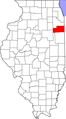 Kankakee County's location in Illinois | |
| Coordinates: 41°15′00″N 87°50′18″W | |
| Country | United States |
| State | Illinois |
| County | Kankakee |
| Established | March 12, 1855 |
| Government | |
| • Supervisor | Alan Williams |
| Area | |
| • Total | 36.68 sq mi (95.0 km2) |
| • Land | 36.58 sq mi (94.7 km2) |
| • Water | 0.1 sq mi (0.3 km2) 0.27% |
| Elevation | 689 ft (210 m) |
| Population (2010) | |
| • Estimate (2016)[1] | 10,877 |
| • Density | 305.8/sq mi (118.1/km2) |
| Time zone | UTC-6 (CST) |
| • Summer (DST) | UTC-5 (CDT) |
| ZIP codes | 60468, 60914, 60950 |
| FIPS code | 17-091-46513 |
Geography
According to the 2010 census, the township has a total area of 36.68 square miles (95.0 km2), of which 36.58 square miles (94.7 km2) (or 99.73%) is land and 0.1 square miles (0.26 km2) (or 0.27%) is water.[2]
Cities, towns, villages
- Bourbonnais (north quarter)
- Bradley (north edge)
- Manteno
Adjacent townships
- Peotone Township, Will County (north)
- Will Township, Will County (northeast)
- Sumner Township (east)
- Ganeer Township (southeast)
- Bourbonnais Township (south)
- Rockville Township (west)
Cemeteries
The township contains these three cemeteries: Elmwood, Saint Joseph and State Hospital.
Major highways
Airports and landing strips
- Brandt Airport
- Brandt Landing Strip
- Phipps Airport
- Spangler Airport
Landmarks
- Heritage Park
Government
The township is governed by an elected Town Board of a Supervisor and four Trustees. The Township also has an elected Assessor, Clerk, Highway Commissioner and Supervisor. The Township Office is located at 452 Water Tower South, Manteno, IL 60950.
Political districts
- Illinois' 2nd congressional district
- State House District 34
- State Senate District 17
School districts
- Manteno Community Unit School District 5
References
- "Manteno Township, Kankakee County, Illinois". Geographic Names Information System. United States Geological Survey. Retrieved 2010-02-20.
- United States Census Bureau 2007 TIGER/Line Shapefiles
- United States National Atlas
- "Population and Housing Unit Estimates". Retrieved June 9, 2017.
- "Population, Housing Units, Area, and Density: 2010 - County -- County Subdivision and Place -- 2010 Census Summary File 1". United States Census. Archived from the original on 2020-02-12. Retrieved 2013-05-28.
- "Census of Population and Housing". Census.gov. Retrieved June 4, 2016.
External links
Municipalities and communities of Kankakee County, Illinois, United States | ||
|---|---|---|
| Cities | Map of Illinois highlighting Kankakee County | |
| Villages | ||
| Townships | ||
| Unincorporated communities | ||
| Footnotes | ‡This populated place also has portions in an adjacent county or counties. | |