Manakau
Manakau is a settlement in the Horowhenua District, at the boundary of the Manawatū-Whanganui and Wellington regions of New Zealand's North Island. It lies 8 km north of Otaki and 12 km south of Levin, and is connected to both via State Highway 1, which skirts Manakau's western edge. The township 5 km inland from the coast of the Tasman Sea.[1]
Manakau | |
|---|---|
 Manakau | |
| Coordinates: 40°43′S 175°19′E | |
| Country | New Zealand |
| Region | Wellington |
| Territorial authority | Kapiti Coast |
| Time zone | UTC+12 (NZST) |
| • Summer (DST) | UTC+13 (NZDT) |
| Area code(s) | 04 |
In 1886, Manakau became the first place to have a railway station on the newly completed Wellington-Manawatu railway line.[2] The line is now part of the North Island Main Trunk line, but the station itself has long been closed. Industries in the area include horticulture,[2] and there are several plant nurseries in or close to the township.
Indigenous significance
The name Manakau comes from the Māori words mana (prestige, authority) and kau (alone, sole). The name refers to an invasion of the district by notable tribal leader Te Rauparaha, who subdued the area on the strength of his prestige alone, with the local residents putting up no resistance.[3] The streets are named after Māori members of Parliament.[2]
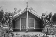
Manakau has two marae, affiliated with local hapū from the Ngāti Raukawa iwi. Tūkorehe Marae and its meeting house of the same name are affiliated with the hapū of Ngāti Tūkorehe; Wehi Wehi Marae and its meeting house of the same name are affiliated with the hapū of Ngāti Wehi Wehi.[4][5]
Education
Manakau School is a co-educational state primary school for Year 1 to 6 students,[6][7] with a roll of 112 as of March 2020.[8]
References
- Dowling, P. (ed.) (2004). ’’Reed New Zealand atlas’’. Auckland: Reed Publishing. Map 48. ISBN 0 7900 0952 8
- McKinnon, M. "Horowhenua," Te Ara - the Encyclopedia of New Zealand, 21 April 2015. Retrieved 21 April 2018.
- Reed, A.W. (1975). Place names of New Zealand. Wellington: A.H. & A.W. Reed. p. 243
- "Te Kāhui Māngai directory". tkm.govt.nz. Te Puni Kōkiri.
- "Māori Maps". maorimaps.com. Te Potiki National Trust.
- "Official School Website". manakau.school.nz.
- "Ministry of Education School Profile". educationcounts.govt.nz. Ministry of Education.
- "Education Review Office Report". ero.govt.nz. Education Review Office.
External links
