Macquarie Island Marine Park
The Macquarie Island Marine Park (previously known as the Macquarie Island Commonwealth Marine Reserve) is an Australian marine park near Macquarie Island in the southwest Pacific. The marine park covers an area of 162,000 km2 (63,000 sq mi) and is assigned IUCN category IV. It is the largest of the 14 parks managed under the South-east Marine Parks Network.[3]
| Macquarie Island Marine Park | |
|---|---|
IUCN category IV (habitat/species management area) | |

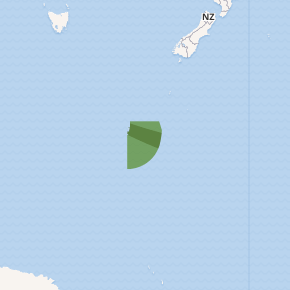
Map showing the Macquarie Island Marine Park. The shaded area is a Sanctuary Zone ('no take' zone).[1] | |
| Location | Australia |
| Coordinates | 56.187°S 161.640°E[2] |
| Area | 162,000 km2 (63,000 sq mi) |
| Established | 20 October 1999 |
| Operator | Parks Australia |
| Website | https://parksaustralia.gov.au/marine/parks/south-east |
Conservation values
- Examples of ecosystems, habitats and communities associated with the Macquarie Province and associated with the sea-floor features: abyssal plain/deep ocean floor, canyon, escarpment, knoll/abyssal hill, ridge, slope and trench/trough
- Important foraging area for: killer whale, southern elephant seal, Antarctic, Subantarctic and New Zealand fur seals, royal, king, rockhopper and gentoo penguin and wandering albatross.[4]
History
The Marine Park was originally proclaimed on 20 October 1999 as the Macquarie Island Marine Park. The name of the reserve was later changed on 28 June 2007 to the Macquarie Island Commonwealth marine reserve.[3] The name was changed again in 2017 back to Macquarie Island Marine Park.[5]
Summary of protection zones
The Macquarie Island Marine Park has been assigned IUCN protected area category IV. However, within the marine park there are two protection zones, each zone has an IUCN category and related rules for managing activities to ensure the protection of marine habitats and species.[3]
The following table is a summary of the zoning rules within the Macquarie Island Marine Park:[3]
| Zone | IUCN | Activities permitted | Total area (km2) | |||||||||||||||||||||||||||||||||||||||||||||||||||||||||||||||||||||||||||||||||||||||||||||||
|---|---|---|---|---|---|---|---|---|---|---|---|---|---|---|---|---|---|---|---|---|---|---|---|---|---|---|---|---|---|---|---|---|---|---|---|---|---|---|---|---|---|---|---|---|---|---|---|---|---|---|---|---|---|---|---|---|---|---|---|---|---|---|---|---|---|---|---|---|---|---|---|---|---|---|---|---|---|---|---|---|---|---|---|---|---|---|---|---|---|---|---|---|---|---|---|---|---|---|
| Vessel transiting | Recreational fishing | Commercial fishing | Commercial tourism | Mining | ||||||||||||||||||||||||||||||||||||||||||||||||||||||||||||||||||||||||||||||||||||||||||||||
| Sanctuary Zone | Ia | Yes | No | No | aviation only | No | 58,000 | |||||||||||||||||||||||||||||||||||||||||||||||||||||||||||||||||||||||||||||||||||||||||||
| Habitat Protection | IV | Yes | Yes | some, with approval | with approval | No | 104,000 | |||||||||||||||||||||||||||||||||||||||||||||||||||||||||||||||||||||||||||||||||||||||||||
| External link: Zoning and rules for the South-east Marine Parks Network | ||||||||||||||||||||||||||||||||||||||||||||||||||||||||||||||||||||||||||||||||||||||||||||||||||
See also
- Protected areas managed by the Australian government
References
- Map data: Sanctuary IUCN Ia and National Park IUCN II zones ('no take' zones) from Australian Marine Parks, (2018) Australian Government Department of the Environment and Energy. CC BY 4.0. http://www.environment.gov.au/fed/catalog/search/resource/details.page?uuid=%7BCD8877F3-8C39-4A20-A53F-070FBEE5AF3C%7D
- "Relation: Macquarie Island Marine Park (8444307)". OpenStreetMap. Retrieved 15 August 2018.
- "South-east Marine Parks Network Management Plan 2013-23" (PDF). Parks Australia. Retrieved 14 August 2018.
- "Macquarie Island Commonwealth Marine Reserve". environment.gov.au. © Commonwealth of Australia (CC BY 3.0 AU). Retrieved 15 August 2018.
- "Environment Protection and Biodiversity Conservation Amendment (Commonwealth Marine Reserves Renaming) Proclamation 2017". legislation.gov.au. Retrieved 15 August 2018.