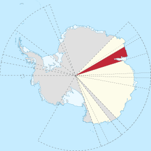
Mac. Robertson Land
Mac. Robertson Land is the portion of Antarctica lying southward of the coast between William Scoresby Bay and Cape Darnley. It is located at 70°00′S 65°00′E. In the east, Mac. Robertson Land includes the Prince Charles Mountains. It was named by the British Australian and New Zealand Antarctic Research Expedition (BANZARE) (1929-1931), under Sir Douglas Mawson, after Sir Macpherson Robertson of Melbourne, a patron of the expedition.[1]

From 1965 onwards, members of the SAE (Soviet Antarctic Expeditions) began undertaking geological fieldwork in the Prince Charles Mountains, eventually establishing a base, Soyuz Station, on the eastern shore of Beaver Lake in the northern Prince Charles Mountains.
Nomenclature
Mac.Robertson Land (no space after Mac.)[2] is the official Australian name, but it is known in the United States as Mac. Robertson Land and in Russia as MacRobertson Land.[3]
References
- Australian Antarctic Division. Mac. Robertson Land Archived 2011-06-02 at the Wayback Machine
- Australian Antarctic Division. "Antarctic Gazetteer". Australian Antarctic Division. Archived from the original on 2012-08-13. Retrieved 2011-07-08.
- SCAR Gazetteer Ref. No 8833 Mac. Robertson Land