M-6 highway (Montenegro)
M-6 highway (Montenegrin: Magistralni put M-6) (previously R-5 and parts of M-8 and R-4) is a Montenegrin roadway.
| ||||
|---|---|---|---|---|
| Magistralni put M-6 | ||||
 | ||||
| Route information | ||||
| Length | 127.0 km (78.9 mi) | |||
| Existed | 2010–present | |||
| Major junctions | ||||
| North end | ||||
| South end | ||||
| Location | ||||
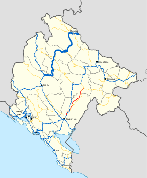
| Municipalities | Pljevlja, Žabljak, Šavnik, Nikšić | |||
| Highway system | ||||
Highways in Montenegro
| ||||

History
Part of the M-6 highway that was previously M-8 highway was built as part of the larger M-8 highway within the Yugoslav highway network, spanning Bosnia and Herzegovina, Montenegro and Serbia. It connected Pljevlja with Foča in Bosnia and Herzegovina, and Prijepolje, Sjenica and Novi Pazar in Serbia.[1] However, construction was never completed on the Montenegrin section of the road.[2]
Section between Jasenovo Polje and Krnovo was only main road built in Montenegro during 1990s. Section from Žabljak to Šavnik was built in 2010.
In January 2016, the Ministry of Transport and Maritime Affairs published bylaw on categorisation of state roads.[3] With new categorisation, M-6 highway was created, from R-5 regional road and parts of previous M-8 highway and R-4 regional road.
Major intersections
| Municipality | Location | km | mi | Destinations | Notes |
|---|---|---|---|---|---|
| Pljevlja | Ranče | 0.0 | 0.0 | Border crossing with Serbia | |
| Trlica | 8.6 | 5.3 | |||
| Pljevlja | 13.7 | 8.5 | |||
| 15.3 | 9.5 | ||||
| Đurđevića Tara | 50.7 | 31.5 | Immediately after Đurđevića Tara Bridge | ||
| Žabljak | Žabljak | 71.5 | 44.4 | No major intersection, bypass east of the city | |
| Virak | 76.4 | 47.5 | |||
| Pošćenski kraj | 79.5 | 49.4 | |||
| Šavnik | Šavnik | 98.4 | 61.1 | ||
| Nikšić | Jasenovo Polje | 127 | 79 | ||
| 1.000 mi = 1.609 km; 1.000 km = 0.621 mi | |||||
References
- "Odluka o utvrđivanju magistralnih puteva" [Decision on determining highways] (PDF) (in Serbo-Croatian). Federal Executive Council. 1984. Archived from the original (PDF) on 24 September 2015. Retrieved 27 May 2015.
8. put Foča - Pljevlja - Prijepolje - Sjenica - Novi Pazar;
- Doderović, Miroslav; Ivanović, Zdravko (Fall 2012). Drumski saobraćaj u Crnoj Gori [Vehicular transport in Montenegro] (PDF) (in Montenegrin). Matica crnogorska. p. 482. Retrieved 24 May 2015.
"Magistralni put Pljevlja – Gradac – Šula (granica sa BiH) je veza Pljevalja sa Fočom, a dionica Pljevlja - Gradac zahtijeva rekonstrukciju sa popravkom horizontalnih elemenata i kompletnu rehabilitaciju kolovoza. Izgradnja magistralnog puta Šula – granica sa BiH je nastavak putnog pravca Pljevlja –Gradac
- "Pravilnik o kategorizaciji državnih puteva" [Regulation on categorisation of state roads]. www.sluzbenilist.me (in Montenegrin). Official Gazette of Montenegro. 5 January 2016. Retrieved 14 February 2019.
| Motorways | ||
|---|---|---|
| Highways | ||
| Regional roads | ||
| ||