Lynx Silver Line
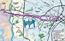
The LYNX Silver Line is a proposed east-west light rail line in Charlotte, North Carolina.[1] The Silver Line would connect the CPCC Levine Campus in Matthews and the proposed Gateway Station in Uptown Charlotte[2][1], and then continue on to the Charlotte Douglas International Airport before terminating in Belmont.
| LYNX Silver Line | ||||||||||||||||||||||||||||||||||||||||||||||||||||||||||||||||||||||||||||||||||||||||||||||||||||||||||||||||||||||||||||||||||||||||||||||||||||||||||||||||||||||||||||||||||||||||||||||||||||||||||||||||||||||||||||||||||||||||||||||||||||||||||||||||||||||||||||||||||||||
|---|---|---|---|---|---|---|---|---|---|---|---|---|---|---|---|---|---|---|---|---|---|---|---|---|---|---|---|---|---|---|---|---|---|---|---|---|---|---|---|---|---|---|---|---|---|---|---|---|---|---|---|---|---|---|---|---|---|---|---|---|---|---|---|---|---|---|---|---|---|---|---|---|---|---|---|---|---|---|---|---|---|---|---|---|---|---|---|---|---|---|---|---|---|---|---|---|---|---|---|---|---|---|---|---|---|---|---|---|---|---|---|---|---|---|---|---|---|---|---|---|---|---|---|---|---|---|---|---|---|---|---|---|---|---|---|---|---|---|---|---|---|---|---|---|---|---|---|---|---|---|---|---|---|---|---|---|---|---|---|---|---|---|---|---|---|---|---|---|---|---|---|---|---|---|---|---|---|---|---|---|---|---|---|---|---|---|---|---|---|---|---|---|---|---|---|---|---|---|---|---|---|---|---|---|---|---|---|---|---|---|---|---|---|---|---|---|---|---|---|---|---|---|---|---|---|---|---|---|---|---|---|---|---|---|---|---|---|---|---|---|---|---|---|---|---|---|---|---|---|---|---|---|---|---|---|---|---|---|---|---|---|---|---|---|---|---|---|---|---|---|---|---|---|---|---|---|---|---|
| Overview | ||||||||||||||||||||||||||||||||||||||||||||||||||||||||||||||||||||||||||||||||||||||||||||||||||||||||||||||||||||||||||||||||||||||||||||||||||||||||||||||||||||||||||||||||||||||||||||||||||||||||||||||||||||||||||||||||||||||||||||||||||||||||||||||||||||||||||||||||||||||
| Type | Light rail | |||||||||||||||||||||||||||||||||||||||||||||||||||||||||||||||||||||||||||||||||||||||||||||||||||||||||||||||||||||||||||||||||||||||||||||||||||||||||||||||||||||||||||||||||||||||||||||||||||||||||||||||||||||||||||||||||||||||||||||||||||||||||||||||||||||||||||||||||||||
| System | Charlotte Area Transit System | |||||||||||||||||||||||||||||||||||||||||||||||||||||||||||||||||||||||||||||||||||||||||||||||||||||||||||||||||||||||||||||||||||||||||||||||||||||||||||||||||||||||||||||||||||||||||||||||||||||||||||||||||||||||||||||||||||||||||||||||||||||||||||||||||||||||||||||||||||||
| Locale | Belmont, Charlotte and Matthews, NC | |||||||||||||||||||||||||||||||||||||||||||||||||||||||||||||||||||||||||||||||||||||||||||||||||||||||||||||||||||||||||||||||||||||||||||||||||||||||||||||||||||||||||||||||||||||||||||||||||||||||||||||||||||||||||||||||||||||||||||||||||||||||||||||||||||||||||||||||||||||
| Termini | Belmont (west) CPCC Levine (east) | |||||||||||||||||||||||||||||||||||||||||||||||||||||||||||||||||||||||||||||||||||||||||||||||||||||||||||||||||||||||||||||||||||||||||||||||||||||||||||||||||||||||||||||||||||||||||||||||||||||||||||||||||||||||||||||||||||||||||||||||||||||||||||||||||||||||||||||||||||||
| Stations | 10 (West Corridor) 13 (Southeast Corridor) | |||||||||||||||||||||||||||||||||||||||||||||||||||||||||||||||||||||||||||||||||||||||||||||||||||||||||||||||||||||||||||||||||||||||||||||||||||||||||||||||||||||||||||||||||||||||||||||||||||||||||||||||||||||||||||||||||||||||||||||||||||||||||||||||||||||||||||||||||||||
| Services | Silver Line | |||||||||||||||||||||||||||||||||||||||||||||||||||||||||||||||||||||||||||||||||||||||||||||||||||||||||||||||||||||||||||||||||||||||||||||||||||||||||||||||||||||||||||||||||||||||||||||||||||||||||||||||||||||||||||||||||||||||||||||||||||||||||||||||||||||||||||||||||||||
| Operation | ||||||||||||||||||||||||||||||||||||||||||||||||||||||||||||||||||||||||||||||||||||||||||||||||||||||||||||||||||||||||||||||||||||||||||||||||||||||||||||||||||||||||||||||||||||||||||||||||||||||||||||||||||||||||||||||||||||||||||||||||||||||||||||||||||||||||||||||||||||||
| Planned opening | 2030 (tentative) | |||||||||||||||||||||||||||||||||||||||||||||||||||||||||||||||||||||||||||||||||||||||||||||||||||||||||||||||||||||||||||||||||||||||||||||||||||||||||||||||||||||||||||||||||||||||||||||||||||||||||||||||||||||||||||||||||||||||||||||||||||||||||||||||||||||||||||||||||||||
| Technical | ||||||||||||||||||||||||||||||||||||||||||||||||||||||||||||||||||||||||||||||||||||||||||||||||||||||||||||||||||||||||||||||||||||||||||||||||||||||||||||||||||||||||||||||||||||||||||||||||||||||||||||||||||||||||||||||||||||||||||||||||||||||||||||||||||||||||||||||||||||||
| Line length | 10 miles (16 km) (West Corridor) 13.5 miles (21.7 km) (Southeast Corridor) | |||||||||||||||||||||||||||||||||||||||||||||||||||||||||||||||||||||||||||||||||||||||||||||||||||||||||||||||||||||||||||||||||||||||||||||||||||||||||||||||||||||||||||||||||||||||||||||||||||||||||||||||||||||||||||||||||||||||||||||||||||||||||||||||||||||||||||||||||||||
| ||||||||||||||||||||||||||||||||||||||||||||||||||||||||||||||||||||||||||||||||||||||||||||||||||||||||||||||||||||||||||||||||||||||||||||||||||||||||||||||||||||||||||||||||||||||||||||||||||||||||||||||||||||||||||||||||||||||||||||||||||||||||||||||||||||||||||||||||||||||
The Southeast Corridor is proposed to follow a path primarily along Independence Boulevard, as it extends through southeastern Mecklenburg County. To be built at a cost of over $1 billion, this portion of the line would be 13.5 miles (21.7 km) long and have 13 stations, 8-10 of which would be park-and-ride. Currently, there is no firm construction schedule in place.[1][2] The West Corridor is proposed to have 10 stations and follow along Wilkinson Boulevard, from Uptown Charlotte west through the Mecklenberg County, entering Gaston County, and terminating in Belmont.
History
Southeast Corridor
The prospect of developing a light rail line between Matthews and Uptown along Independence Boulevard was initially evaluated in 1985.[3] By 1997, the Charlotte City Council voted, at the recommendation of an independent transit panel, for the development of a busway in the median of Independence in lieu of light rail.[4] The decision to develop a busway over light rail was based on overall costs of $126 million for a busway versus $300 million for light-rail.[5] However, by 1999 delays in the construction of the busway resulted in a renewed grassroots effort of rail advocates to have light rail placed along Independence.[5] As a result of this campaign, Representative Robin Hayes, who served as a member of the House Transportation Committee, to design the busway in such a manner as to be adapted for light rail when it can be economically justified.[6] In 2002, the Metropolitan Transit Commission recommended that the Independence corridor see the construction, but that as part of the initial engineering studies, light rail accommodation be considered.
By 2006, a study released by the Charlotte Area Transit System indicated that the cost of light rail along the corridor would be roughly double that of a busway and have fewer riders.[7] The estimates stated light rail on Independence would be 12.7 miles (20.4 km) in length at a cost of $585 million, with a projected ridership of 14,400 in 2030; and stated a busway would be 13.5 miles (21.7 km) in length at a cost of $315 to $325 million, with a projected ridership of 16,000 in 2030.[7] In September, the MTC voted to delay on determining whether a busway or light rail should be built along the corridor until 2011.[8]
By October 2012, the MTC had voted in favor of a busway on interior lanes of the highway.[9] However, in May 2013, a 30-member funding task force suggested a light rail line instead, at an estimated cost of $1.7 billion.[10] The 2006 study had estimated the line would be 13.5 miles (21.7 km) and be complete through Idlewild Road by 2022, to Sardis Road North by 2024 and finally to CPCC Levine by 2026. Additionally, the line would contain 3,350 parking spaces and 16 stations along the corridor at a cost of $582 million.[2]
In September 2016, after three years of further studies and consultations with area residents, CATS settled on light rail as the most viable option for the Silver Line. At the time, however, CATS lacked any further sources of funding to invest in future projects. John Lewis, the system's CEO, said he would wait for the Blue Line Extension to begin service in August 2017 before resuming discussions on how best to fund the new lines. A possible option could be to have neighboring counties contribute towards project costs.[1] The Silver Line would come within less than a mile of the Union County border at the CPCC Levine Station. Lynx Silver Line will have 13 stations with about 10 having park-and-ride lots.
In January 2019, CATS announced that the Silver Line would cross from Independence Boulevard over to 11th Street, run parallel to I-277 to North Graham Street, then turn south to link to the planned Gateway Station and continuation along the West Corridor.[11][12]
West Corridor
The West Corridor was proposed as a streetcar line to serve as an extension for the LYNX network in Charlotte, North Carolina, initially slated for completion by 2034. It would connect Charlotte-Douglas International Airport in west Charlotte with the Charlotte Transportation Center in Uptown Charlotte.[2] It was to follow a primarily east-west path along West Morehead Street and Wilkinson Boulevard, through west Charlotte. The first phase was estimated to be 6.4 miles (10.3 km) with 10 stops. It was to be completed between Uptown and Ashley Road by 2029 at a cost of $163 million. The second phase between Ashley Road and the Charlotte-Douglas International Airport was scheduled for completion by 2034 at a cost of $324 million.[2]
In July 2018, CATS began a reevaluation of the West Corridor, which replaces the originally planned streetcar into two possible light rail routes from Belmont and Charlotte Douglas International Airport to Charlotte Center City and continuation along the planned Southeast Corridor to Matthews. The process involves a series of public meetings and various surveys to know where the public stands regarding the West Corridor and how each of the alternative options rank.[13][14][15]
In January 2019, CATS reaffirmed that the West Corridor would be a continuation of the Lynx Silver Line, from the planned Gateway Station, in Uptown, to Belmont. It was also confirmed that the route would travel along Wilkinson Boulevard, dropping the alternative routing along Alleghany and Tuckaseegee roads.[16][17] On February 27, 2019, the Metropolitan Transit Commission unanimously approved to merge the West Corridor into the Lynx Silver Line.[18]
External links
References
- Harrison, Steve (September 14, 2016). "CATS unveils new route for Silver Line along Independence Boulevard". The Charlotte Observer.
- "Destination 2030". Charlotte Area Transit System. p. 10. Retrieved 2007-06-25.
- Israel, Mae (August 8, 1985). "County rail system ahead?". The Charlotte Observer. pp. Metro 1.
- Whitacre, Dianne (April 27, 1997). "Transit experts endorse busways". The Charlotte Observer. pp. 1B.
- Whitacre, Dianne (March 21, 1999). "Rail boosters energized by busway's woes". The Charlotte Observer. pp. 1B.
- Whitacre, Dianne (November 16, 2002). "Hayes says keep rail in picture". The Charlotte Observer. pp. 4B.
- Rubin, Richard (July 26, 2006). "Costs could derail hopes on East Side". The Charlotte Observer. pp. 1A.
- Rubin, Richard (September 28, 2006). "Rail? Bus? Neither for now". The Charlotte Observer. pp. 1A.
- Harrison, Steve (October 15, 2012). "Light-rail extension moves to fast track; CATS to announce federal funding for uptown-to-UNCC line". The Charlotte Observer.
- Harrison, Steve (May 6, 2013). "Group suggests new transit tax, private help". The Charlotte Observer.
- Portillo, Ely (January 23, 2019). "No mile-long tunnel under uptown: CATS recommends a different route for light rail". The Charlotte Observer. Retrieved January 23, 2019.
- Harrison, Steve (January 23, 2019). "CATS Gives New Details On 2030 Plan, Including New Rail Along I-277". Charlotte, NC: WFAE. Retrieved January 23, 2019.
- Boraks, David (July 18, 2018). "CATS Eyes New Light Rail, Bus And Uptown Tunnel Options". Charlotte, NC: WFAE. Retrieved July 18, 2018.
- Barret, Michael (July 18, 2018). "Should light rail stop in Belmont or come to Gastonia?". The Gaston Gazette. Retrieved July 18, 2018.
- "West Corridor Init Screening Brochure" (pdf). Charlotte Area Transit System. July 16, 2018. Retrieved July 18, 2018.
- Portillo, Ely (January 23, 2019). "No mile-long tunnel under uptown: CATS recommends a different route for light rail". The Charlotte Observer. Retrieved January 23, 2019.
- Harrison, Steve (January 23, 2019). "CATS Gives New Details On 2030 Plan, Including New Rail Along I-277". Charlotte, NC: WFAE. Retrieved January 23, 2019.
- Hughes, Rob; Goldner, Brandon (February 28, 2019). "Commission approves plan for new light rail from Belmont to Matthews". Charlotte, NC: WCNC-TV. Retrieved February 28, 2019.