Low, Quebec
Low is a township municipality in the La Vallée-de-la-Gatineau Regional County Municipality of western Quebec, Canada. It is situated along the Gatineau River north of Wakefield, and it is located within Canada's National Capital Region. Its 2006 population was 956.
Low | |
|---|---|
Township municipality | |
 | |
| Nickname(s): Paugan | |
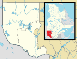 Low Location in western Quebec. | |
| Coordinates: 45°49′N 75°57′W[1] | |
| Country | Canada |
| Province | Quebec |
| Region | Outaouais |
| RCM | La Vallée-de-la-Gatineau |
| Constituted | 1 January 1858 |
| Government | |
| • Mayor | Carole Robert |
| • Federal riding | Pontiac |
| • Prov. riding | Gatineau |
| Area | |
| • Total | 276.32 km2 (106.69 sq mi) |
| • Land | 257.40 km2 (99.38 sq mi) |
| Population | |
| • Total | 982 |
| • Density | 3.8/km2 (10/sq mi) |
| • Pop (2011–16) | |
| • Dwellings | 961 |
| Time zone | UTC−05:00 (EST) |
| • Summer (DST) | UTC−04:00 (EDT) |
| Postal code(s) | J0X 2C0 |
| Area code(s) | 819 |
| Access Routes | |
| Website | www |
Low received its name from Charles Adamson Low, a lumber merchant who held timber rights in the Gatineau Valley.
A section of Low called Tucker Lake was home of the Gatineau Clog, a country music festival founded by Wayne Rostad in 1980 until 1995.
The mayor of Low is Carole Robert elected in November 2017. The two most recent former mayors were Morris O'Connor and Michael Francis who was mayor back in the mid- eighties, and was re-elected in 1997. Michael announced his retirement in the summer of 2009, and finished his term November 2009.
Geography
Low is situated in a corner of mountainous terrain on the edge of the Gatineau Hills, but conducive to agriculture.[4] It is dotted with an abundance of lakes, most notably Sainte-Marie, Island, Doyle, cameron, and Venosta Lakes.[5]
History
Low represents a rare case where the township was formed after the municipality; the township dates back to 1859 whereas the municipality was founded in 1848 and the municipality township was officially established on 1 January 1857, and which came into force on 1 January 1858. It was named after Charles Adamson Low, an important timber merchant of the region in the mid 19th century, a time when many Irish immigrants settled here. Its post office was established in 1854.[4]
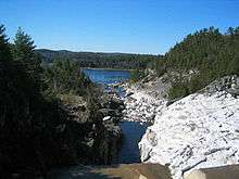
In 1928 the village of Low Quebec built the Paugan hydroelectric dam. This caused the voluntarily flooding of the village to the north, Lac Saint Marie, Quebec. Because of the dam, 90% of village of Lac Saint Marie had to be relocated to higher grounds
Demographics
Population trend:[6]
- Population in 2016: 982 (2011 to 2016 population change: 6.7%)
- Population in 2011: 920 (2006 to 2011 population change: -3.8%)
- Population in 2006: 956 (2001 to 2006 population change: 12.2%)
- Population in 2001: 852
- Population in 1996: 807
- Population in 1991: 892
Private dwellings (occupied by usual residents): 462
Languages:
- English as first language: 52.3%
- French as first language: 46.7%
- Other as first language: 1.0%
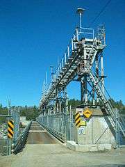
Paugan Hydroelectric Station
The Paugan Station (Centrale de Paugan), built in 1928, is a run-of-river hydroelectric power station and dam on the Gatineau river, operated by Hydro-Québec. It has a head of 40.5 m (133 ft), and 8 turbines with a total capacity of 202 MW. Its reservoir is 30 km2 (12 sq mi).[7]
References
- Reference number 37349 of the Commission de toponymie du Québec (in French)
- Geographic code 83010 in the official Répertoire des municipalités (in French)
- "2016 Census results". Statistics Canada. Retrieved 4 July 2020.
- "Municipalité de Canton de Low" (in French). Commission de toponymie du Québec. Retrieved 21 July 2008.
- "Canton de Low" (in French). Commission de toponymie du Québec. Retrieved 21 July 2008.
- Statistics Canada: 1996, 2001, 2006, 2011 2016 census
- "Centrale de Paugan". Hydro-Québec. Archived from the original on 29 September 2007. Retrieved 21 July 2008.
Places adjacent to Low, Quebec | ||||||||||
|---|---|---|---|---|---|---|---|---|---|---|
| ||||||||||
| Cities | |
|---|---|
| Municipalities | |
| Townships | |
| Unorganized territories |
|
| |