Lac-Moselle, Quebec
Lac-Moselle is an unorganized territory in the Outaouais region of Quebec, Canada. It is one of the five unorganized and unpopulated wilderness areas in the La Vallée-de-la-Gatineau Regional County Municipality. It is named after Lake Moselle.
Lac-Moselle | |
|---|---|
Unorganized territory | |
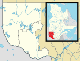 Lac-Moselle Location in western Quebec. | |
| Coordinates: 47°31′N 75°35′W[1] | |
| Country | |
| Province | |
| Region | Outaouais |
| RCM | La Vallée-de-la-Gatineau |
| Constituted | January 1, 1986 |
| Government | |
| • Federal riding | Pontiac |
| • Prov. riding | Gatineau |
| Area | |
| • Total | 1,270.30 km2 (490.47 sq mi) |
| • Land | 1,153.80 km2 (445.48 sq mi) |
| Population (2011)[3] | |
| • Total | 0 |
| • Density | 0.0/km2 (0/sq mi) |
| • Pop (2006–11) | |
| • Dwellings | 0 |
| Time zone | UTC−5 (EST) |
| • Summer (DST) | UTC−4 (EDT) |
Demographics
Population trend:
- Population in 2011: 0
- Population in 2006: 0
- Population in 2001: 0
- Population in 1993: 0
- Population in 1989: 0
gollark: What the apioids is `msg[0]` in qualitybot?
gollark: Great, now it just says "improper token".
gollark: I just see a bunch of `*`.
gollark: ABR's logic is *not*, actually, hmm.
gollark: WHY WOULD YOU THAT WHAT EVEN WHYYYYY
References
- Reference number 149713 of the Commission de toponymie du Québec (in French)
- Geographic code 83908 in the official Répertoire des municipalités (in French)
- "(Code 2483908) Census Profile". 2011 census. Statistics Canada. 2012.
Places adjacent to Lac-Moselle, Quebec | ||||||||||
|---|---|---|---|---|---|---|---|---|---|---|
| ||||||||||
| Cities | |
|---|---|
| Municipalities | |
| Townships | |
| Unorganized territories |
|
| |
This article is issued from Wikipedia. The text is licensed under Creative Commons - Attribution - Sharealike. Additional terms may apply for the media files.