Long Hollow, South Dakota
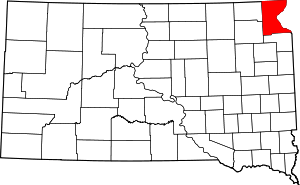
Long Hollow is an unincorporated community and census-designated place in Roberts County, South Dakota, United States. Its population was 192 as of the 2010 census.[1]
Long Hollow, South Dakota | |
|---|---|
 Long Hollow, South Dakota  Long Hollow, South Dakota | |
| Coordinates: 45°40′56″N 97°09′40″W | |
| Country | United States |
| State | South Dakota |
| County | Roberts |
| Area | |
| • Total | 14.550 sq mi (37.68 km2) |
| • Land | 14.432 sq mi (37.38 km2) |
| • Water | 0.118 sq mi (0.31 km2) |
| Elevation | 1,696 ft (517 m) |
| Population | |
| • Total | 192 |
| • Density | 13/sq mi (5.1/km2) |
| Time zone | UTC-6 (Central (CST)) |
| • Summer (DST) | UTC-5 (CDT) |
| Area code(s) | 605 |
| GNIS feature ID | 2584559[2] |
Geography
According to the U.S. Census Bureau, the community has an area of 14.550 square miles (37.68 km2); 14.432 square miles (37.38 km2) of its area is land, and 0.118 square miles (0.31 km2) is water.[1]
gollark: Humans are VERY BAD at that. We can barely even acknowledge stuff like positive-sum "games".
gollark: ↑ someone who has never interacted with any humans
gollark: Plus extra voting-related issues - you have to integrate EVERYONE'S DIFFERENT VALUES into your central plan, and somehow have people vote on incredibly complex plans.
gollark: As I said, you're still stuck with every single other issue of it.
gollark: What, voting on central planning?
References
- "2010 Census Gazetteer Files - Places: South Dakota". U.S. Census Bureau. Retrieved January 28, 2017.
- "Long Hollow Census Designated Place". Geographic Names Information System. United States Geological Survey.
This article is issued from Wikipedia. The text is licensed under Creative Commons - Attribution - Sharealike. Additional terms may apply for the media files.
