List of listed buildings in Kirkmichael, South Ayrshire
List
| Name | Location | Date Listed | Grid Ref. [note 1] | Geo-coordinates | Notes | LB Number [note 2] | Image |
|---|---|---|---|---|---|---|---|
| Guiltreehill | 55°21′47″N 4°35′27″W | Category C(S) | 13783 |  | |||
| 8 Patna Road Kirkmichael | 55°20′45″N 4°37′04″W | Category B | 7547 | | |||
| 16 Patna Road Kirkmichael | 55°20′45″N 4°37′02″W | Category B | 7548 | | |||
| Adjoining 20 Patna Road Kirkmichael | 55°20′46″N 4°37′00″W | Category C(S) | 7550 | | |||
| Crosshill Village Nos. 15-91 (Odd Numbers Only) Dalhowan Street | 55°19′26″N 4°38′21″W | Category B | 7559 | | |||
| 31 Patna Road Kirkmichael | 55°20′47″N 4°36′57″W | Category C(S) | 7538 | | |||
| Duniquaich 39 Patna Road Kirkmichael | 55°20′47″N 4°36′56″W | Category B | 7540 | | |||
| Parkfairn | 55°19′13″N 4°37′15″W | Category C(S) | 50005 | | |||
| 36 Patna Road Kirkmichael | 55°20′46″N 4°36′56″W | Category B | 13653 | | |||
| 40 Patna Road Kirkmichael | 55°20′47″N 4°36′55″W | Category C(S) | 13656 | | |||
| Cloncaird Castle, Stable Block And Boundary Wall, Steps And Ancillary Structures | 55°20′09″N 4°35′17″W | Category C(S) | 11740 | | |||
| 30 Patna Road (Mr Mcculloch, Plasterer) Kirkmichael | 55°20′46″N 4°36′58″W | Category C(S) | 7551 | | |||
| 32 Patna Road Kirkmichael | 55°20′46″N 4°36′57″W | Category C(S) | 7552 | | |||
| Hillburn 76 Patna Road Kirkmichael | 55°20′47″N 4°36′41″W | Category C(S) | 7553 | | |||
| Gatepiers, Kirkmichael House | 55°20′31″N 4°36′49″W | Category B | 7554 | | |||
| Blairquhan Bridge | 55°20′20″N 4°35′56″W | Category B | 7555 | | |||
| Kirkmichael Arms, The White House And Adjoining Joiner's Shop | 55°20′45″N 4°37′04″W | Category B | 7544 | | |||
| 60 Patna Road Kirkmichael | 55°20′47″N 4°36′50″W | Category C(S) | 7565 | | |||
| 43 Patna Road Kirkmichael | 55°20′47″N 4°36′55″W | Category B | 7541 | | |||
| 45 Patna Road Kirkmichael | 55°20′47″N 4°36′54″W | Category B | 7542 | | |||
| Myrtle Cottage 47 Patna Road Kirkmichael | 55°20′47″N 4°36′54″W | Category B | 7543 | | |||
| Cloncaird Castle, Former Garage And Store | 55°20′10″N 4°35′18″W | Category C(S) | 50618 | | |||
| 42 Patna Road Kirkmichael | 55°20′47″N 4°36′54″W | Category C(S) | 7561 | | |||
| Kirkmichael, 2 Burnside Row, The Auld Posthouse | 55°20′47″N 4°36′53″W | Category C(S) | 7562 | | |||
| 58 Patna Road (Now Belongs To 50) Kirkmichael | 55°20′47″N 4°36′51″W | Category C(S) | 7564 | | |||
| Kirkmichael Parish Church, (Church Of Scotland) | 55°20′48″N 4°36′39″W | Category B | 7534 | | |||
| Lych Gate And Graveyard | 55°20′49″N 4°36′39″W | Category B | 7535 | | |||
| Rose Cottage 37 Patna Road Kirkmichael | 55°20′47″N 4°36′57″W | Category C(S) | 7539 | | |||
| Cloncaird Castle, Bridge | 55°20′07″N 4°35′21″W | Category C(S) | 13782 | | |||
| Blairquhan Estate, Blairquhan Lodge | 55°20′19″N 4°35′57″W | Category C(S) | 11738 | | |||
| The Manse 63 Patna Road Kirkmichael | 55°20′50″N 4°36′53″W | Category B | 7545 | | |||
| Longhill | 55°18′55″N 4°36′36″W | Category B | 7556 | | |||
| Dovecote, Drumfad | 55°20′21″N 4°35′08″W | Category A | 7558 | | |||
| Tolverne 38 Patna Road Kirkmichael | 55°20′46″N 4°36′55″W | Category C(S) | 7560 | | |||
| Bridge, Portcheck | 55°20′47″N 4°36′45″W | Category B | 7536 | | |||
| Cassillis Castle | 55°22′52″N 4°37′16″W | Category A | 13655 | 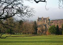 | |||
| Cloncaird Castle | 55°20′04″N 4°35′25″W | Category B | 7557 | | |||
| 74 Patna Road Kirkmichael | 55°20′47″N 4°36′43″W | Category C(S) | 7566 | | |||
| Fairholm 34 Patna Road Kirkmichael | 55°20′46″N 4°36′57″W | Category C(S) | 7533 | | |||
| 20 Patna Road Kirkmichael | 55°20′46″N 4°37′01″W | Category C(S) | 7549 | | |||
| Kirkmichael House | 55°20′31″N 4°37′04″W | Category B | 13654 | | |||
| 62 Patna Road Kirkmichael | 55°20′47″N 4°36′50″W | Category C(S) | 13657 | | |||
| 81 Patna Road Kirkmichael | 55°20′48″N 4°36′42″W | Category C(S) | 7546 | | |||
| Almar 50 Patna Road Kirkmichael | 55°20′47″N 4°36′51″W | Category C(S) | 7563 | | |||
| Portcheck 3 Bolestyle Road Kirkmichael | 55°20′46″N 4°36′44″W | Category C(S) | 7537 | |
Key
The scheme for classifying buildings in Scotland is:
- Category A: "buildings of national or international importance, either architectural or historic; or fine, little-altered examples of some particular period, style or building type."[1]
- Category B: "buildings of regional or more than local importance; or major examples of some particular period, style or building type, which may have been altered."[1]
- Category C: "buildings of local importance; lesser examples of any period, style, or building type, as originally constructed or moderately altered; and simple traditional buildings which group well with other listed buildings."[1]
In March 2016 there were 47,288 listed buildings in Scotland. Of these, 8% were Category A, and 50% were Category B, with the remaining 42% being Category C.[2]
Notes
- Sometimes known as OSGB36, the grid reference (where provided) is based on the British national grid reference system used by the Ordnance Survey.
• "Guide to National Grid". Ordnance Survey. Retrieved 2007-12-12.
• "Get-a-map". Ordnance Survey. Retrieved 2007-12-17. - Historic Environment Scotland assign a unique alphanumeric identifier to each designated site in Scotland, for listed buildings this always begins with "LB", for example "LB12345".
gollark: So copy-cat with potatoS?
gollark: JS is inevitable. Atwood is coming for you.
gollark: I'm looking at making PotatOS for x86™ images.
gollark: Oh, so it's JavaScript.
gollark: oh no.
References
- All entries, addresses and coordinates are based on data from Historic Scotland. This data falls under the Open Government Licence
- "What is Listing?". Historic Environment Scotland. Retrieved 29 May 2018.
- Scotland's Historic Environment Audit 2016 (PDF). Historic Environment Scotland and the Built Environment Forum Scotland. pp. 15–16. Retrieved 29 May 2018.
This article is issued from Wikipedia. The text is licensed under Creative Commons - Attribution - Sharealike. Additional terms may apply for the media files.