List of listed buildings in Colmonell, South Ayrshire
List
| Name | Location | Date Listed | Grid Ref. [note 1] | Geo-coordinates | Notes | LB Number [note 2] | Image |
|---|---|---|---|---|---|---|---|
| Limekilns Near Bougang Farm | 55°07′43″N 4°57′31″W | Category C(S) | 4879 |  | |||
| 4-10 (Even Numbers) Rowantree Street Colmonell | 55°07′58″N 4°54′41″W | Category C(S) | 1043 | | |||
| 55 Main Street | 55°08′01″N 4°54′23″W | Category C(S) | 1046 | | |||
| 57-63 (Odd) Main Street | 55°08′01″N 4°54′22″W | Category C(S) | 1047 | | |||
| Knockdolian | 55°07′42″N 4°56′44″W | Category B | 1049 | | |||
| Kildonan House | 55°06′38″N 4°46′49″W | Category A | 1052 | 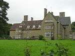 | |||
| Parish Church And Churchyard | 55°07′53″N 4°54′44″W | Category B | 1040 | | |||
| 1-7 (Odd Numbers) Rowntree Street Colmonell | 55°07′57″N 4°54′41″W | Category C(S) | 1044 | | |||
| Pinwherry Castle | 55°08′32″N 4°49′45″W | Category B | 1057 | | |||
| Kirkhill | 55°08′01″N 4°54′37″W | Category B | 1042 | | |||
| 39-43 (Odd) Main Street | 55°08′00″N 4°54′25″W | Category C(S) | 1045 | | |||
| Colmonell Bridge | 55°07′49″N 4°54′14″W | Category B | 1050 | | |||
| Memorial Stone On Sea Shore, Lendalfoot | 55°10′17″N 4°56′00″W | Category B | 1059 | | |||
| Daljarrock Hotel | 55°09′17″N 4°49′57″W | Category B | 104 | | |||
| Manse Road, Colmonell Manse, Including Ancillary Buildings And Boundary Walls | 55°07′53″N 4°54′47″W | Category C(S) | 49938 | | |||
| 65 Main Street | 55°08′02″N 4°54′21″W | Category C(S) | 103 | | |||
| Barrhill, Former Arnsheen Church | 55°06′19″N 4°46′32″W | Category C(S) | 51617 | | |||
| Railway Viaduct Near Pinmore | 55°10′51″N 4°49′36″W | Category B | 1055 | 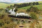 | |||
| Knockdolian Castle | 55°07′38″N 4°56′44″W | Category B | 1048 | | |||
| Craigneil Castle | 55°07′38″N 4°54′28″W | Category B | 1051 | | |||
| Martyr's Tomb Barrhill | 55°06′00″N 4°46′19″W | Category B | 1054 | | |||
| Kirkhill Castle | 55°08′00″N 4°54′36″W | Category B | 1041 | | |||
| Ballochmorrie | 55°07′21″N 4°48′16″W | Category B | 1053 | | |||
| Pinmore Bridge | 55°10′15″N 4°49′24″W | Category B | 1056 | | |||
| Carleton Castle | 55°09′53″N 4°55′57″W | Category B | 1058 | |
Key
The scheme for classifying buildings in Scotland is:
- Category A: "buildings of national or international importance, either architectural or historic; or fine, little-altered examples of some particular period, style or building type."[1]
- Category B: "buildings of regional or more than local importance; or major examples of some particular period, style or building type, which may have been altered."[1]
- Category C: "buildings of local importance; lesser examples of any period, style, or building type, as originally constructed or moderately altered; and simple traditional buildings which group well with other listed buildings."[1]
In March 2016 there were 47,288 listed buildings in Scotland. Of these, 8% were Category A, and 50% were Category B, with the remaining 42% being Category C.[2]
Notes
- Sometimes known as OSGB36, the grid reference (where provided) is based on the British national grid reference system used by the Ordnance Survey.
• "Guide to National Grid". Ordnance Survey. Retrieved 2007-12-12.
• "Get-a-map". Ordnance Survey. Retrieved 2007-12-17. - Historic Environment Scotland assign a unique alphanumeric identifier to each designated site in Scotland, for listed buildings this always begins with "LB", for example "LB12345".
gollark: This would actually be really interesting if true.
gollark: This is so stupid. Honestly, soul harvesters are *decades* old now.
gollark: COVID-19 was created by unknown parties after being funded in a Kickstarter which was taken as a joke.
gollark: COVID-19 was created by sapient *giant squid* as part of an ongoing war against the bats, and spread to humans accidentally.
gollark: COVID-19 was created by sapient bats attempting to manipulate mankind into becoming their slaves.
References
- All entries, addresses and coordinates are based on data from Historic Scotland. This data falls under the Open Government Licence
- "What is Listing?". Historic Environment Scotland. Retrieved 29 May 2018.
- Scotland's Historic Environment Audit 2016 (PDF). Historic Environment Scotland and the Built Environment Forum Scotland. pp. 15–16. Retrieved 29 May 2018.
This article is issued from Wikipedia. The text is licensed under Creative Commons - Attribution - Sharealike. Additional terms may apply for the media files.