List of lighthouses in Wales
This is a list of lighthouses in Wales. The list runs anticlockwise from north-east to south-east Wales.[1][2][3]

St.Ann's Head
Nash Point
Major lighthouses of Wales, Smalls Lighthouse not shown.
Lighthouses
| Lighthouse | Image | County coordinates Grid Reference |
Year built | Tower height | Focal height | Range | Notes |
|---|---|---|---|---|---|---|---|
| Point of Ayr |  | Clwyd 53.3570°N 3.3222°W SJ 121 853 | 1776 | 18 m (59 ft) | Unknown | Inactive | Decommissioned in 1883 |
| Great Orme | 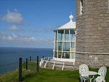 | Gwynedd 53.3423°N 3.8689°W SH 756 845 | 1862 | 11 m (36 ft) | Unknown | Inactive | Decommissioned in 1985 |
| Trwyn Du |  | Anglesey 53.31294°N 4.04067°W SH 644 815 | 1838 | 29 m (95 ft) | 19 m (62 ft) | 12 nmi (22 km) | |
| Point Lynas |  | Anglesey 53.41682°N 4.28909°W SH 479 936 | 1835 | 11 m (36 ft) | 39 m (128 ft) | 18 nmi (33 km) | |
| Amlwch |  | Anglesey 53.4154°N 4.333°W SH 452 937 | 1853 | 11 m (36 ft) | Unknown | Inactive | Decommissioned in the 1970s |
| Skerries |  | Anglesey 53.4212°N 4.6083°W SH 268 948 | 1717 | 23 m (75 ft) | 36 m (118 ft) | 20 nmi (37 km) | |
| Holyhead Mail Pier |  | Anglesey 53.3142°N 4.6199°W SH 256 829 | 1821 | 15 m (49 ft) | Unknown | Inactive | Decommissioned |
| Holyhead Breakwater | .jpg) | Anglesey 53.3317°N 4.62°W SH 257 848 | 1873 | 19 m (62 ft) | 21 m (69 ft) | 14 nmi (26 km) | |
| South Stack |  | Anglesey 53.3068°N 4.6995°W SH 202 823 | 1809 | 28 m (92 ft) | 60 m (197 ft) | 24 nmi (44 km) | |
| Tŵr Mawr |  | Anglesey 53.1352°N 4.4155°W SH 385 625 | 1845 | 11 m (36 ft) | Unknown | Inactive | Decommissioned in 1975 |
| Tŵr Bach |  | Anglesey 53.1342°N 4.4128°W SH 385 625 | 1800s | 5 m (16 ft) | 12 m (39 ft) | 7 nmi (13 km) | |
| Bardsey |  | Gwynedd 52.74996°N 4.79961°W SH 111 206 | 1821 | 30 m (98 ft) | 39 m (128 ft) | 18 nmi (33 km) | |
| St Tudwal's | 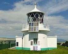 | Gwynedd 52.79818°N 4.47138°W SH 334 252 | 1877 | 11 m (36 ft) | 46 m (151 ft) | 14 nmi (26 km) | |
| Strumble Head |  | Pembrokeshire 52.02972°N 5.07391°W SM 892 413 | 1908 | 17 m (56 ft) | 45 m (148 ft) | 26 nmi (48 km) | |
| South Bishop |  | Pembrokeshire 51.85266°N 5.41195°W SM 651 226 | 1839 | 11 m (36 ft) | 44 m (144 ft) | 16 nmi (30 km) | |
| Smalls |  | Pembrokeshire 51.72121°N 5.66984°W SM 467 089 | 1861 | 41 m (135 ft) | 36 m (118 ft) | 18 nmi (33 km) | |
| Skokholm |  | Pembrokeshire 51.69387°N 5.28698°W SM 729 046 | 1916 | 18 m (59 ft) | 54 m (177 ft) | 8 nmi (15 km) | |
| St.Ann's Head |  | Pembrokeshire 51.68126°N 5.17373°W SM 806 028 | 1841 | 13 m (43 ft) | 48 m (157 ft) | 18 nmi (33 km) | |
| St.Ann's Head High |  | Pembrokeshire 51.6824°N 5.1755°W SM 806 029 | 1714 | 23 m (75 ft) | Unknown | Inactive | Decommissioned in 1910 |
| Great Castle Head |  | Pembrokeshire 51.71°N 5.1167°W SM 847 060 | 1870 | 5 m (16 ft) | 27 m (89 ft) | 5 nmi (9 km) | |
| Little Castle Head | Pembrokeshire 51.7167°N 5.1083°W SM 848 061 | Unknown | 26 m (85 ft) | 53 m (174 ft) | 15 nmi (28 km) | ||
| Watwick Point | Pembrokeshire 51.6967°N 5.1533°W SM 821 044 | Unknown | 50 m (164 ft) | 80 m (262 ft) | 15 nmi (28 km) | ||
| West Blockhouse Point | Pembrokeshire 51.6883°N 5.1583°W SM 818 035 | Unknown | 14 m (46 ft) | 54 m (177 ft) | 9 nmi (17 km) | ||
| Caldey | 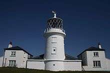 | Pembrokeshire 51.63156°N 4.68427°W SS 143 959 | 1829 | 16 m (52 ft) | 65 m (213 ft) | 13 nmi (24 km) | |
| Saundersfoot |  | Pembrokeshire 51.71°N 4.695°W SN 138 047 | 1848 | 5 m (16 ft) | 7 m (23 ft) | 7 nmi (13 km) | |
| Burry Port |  | Carmarthenshire 51.6775°N 4.2512°W SN 444 000 | 1842 | 6 m (20 ft) | 7 m (23 ft) | 7 nmi (13 km) | |
| Whiteford | 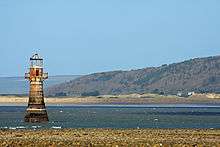 | Swansea 51.6252°N 4.2511°W SS 443 973 | 1865 | 14 m (46 ft) | Unknown | Inactive | Decommissioned in 1926 |
| Mumbles | 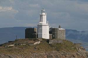 | Swansea 51.56685°N 3.97103°W SS 634 872 | 1794 | 17 m (56 ft) | 35 m (115 ft) | 15 nmi (28 km) | |
| Porthcawl |  | Bridgend 51.4733°N 3.7°W SS 821 763 | 1860 | 9 m (30 ft) | 10 m (33 ft) | 6 nmi (11 km) | |
| Nash Point |  | Vale of Glamorgan 51.40085°N 3.55213°W SS 921 680 | 1832 | 37 m (121 ft) | 56 m (184 ft) | 21 nmi (39 km) | |
| Nash Point Low |  | Vale of Glamorgan 51.4012°N 3.5566°W SS 918 681 | 1832 | 20 m (66 ft) | Unknown | Inactive | Decommissioned in 1900s |
| Flat Holm | 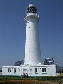 | Cardiff 51.37564°N 3.11871°W ST 222 647 | 1737 | 30 m (98 ft) | 50 m (164 ft) | 15 nmi (28 km) | |
| Barry Docks Breakwater | .jpg) | Vale of Glamorgan 51.39°N 3.285°W ST 125 665 | 1890 | 9 m (30 ft) | 12 m (39 ft) | 10 nmi (19 km) | |
| Monkstone |  | Vale of Glamorgan 51.415°N 3.1°W ST 235 691 | 1993 | 23 m (75 ft) | 21 m (69 ft) | 12 nmi (22 km) | |
| West Usk | 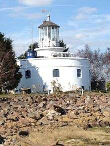 | Monmouthshire 51.5906°N 2.9921°W ST 311 829 | 1821 | 17 m (56 ft) | Unknown | Inactive | Decommissioned in 1922 |
| East Usk |  | Monmouthshire 51.5399°N 2.967°W ST 330 828 | 1893 | 11 m (36 ft) | 11 m (36 ft) | 11 nmi (20 km) | |
See also
- List of lighthouses and lightvessels
- List of lighthouses in England
- List of lighthouses in Scotland
- List of lighthouses in the Isle of Man
- List of lighthouses in Ireland
References
- Douglas Bland Hague (1994). Hughes, Stephen (ed.). Lighthouses of Wales: Their Architecture and Archaeology. Royal Commission on the Ancient and Historical Monuments of Wales. pp. 1–. ISBN 978-1-871184-08-2.
- Rowlett, Russ. "Lighthouses of Wales". The Lighthouse Directory. University of North Carolina at Chapel Hill. Retrieved 21 July 2015.
- List of Lights, Pub. 114: British Isles, English Channel and North Sea (PDF). List of Lights. United States National Geospatial-Intelligence Agency. 2015. p. 78.
External links
| Wikimedia Commons has media related to Lighthouses in Wales. |
- Royal Commission on the Ancient and Historical Monuments of Wales in English and Welsh
Lighthouses and lightvessels in Europe | |
|---|---|
| Sovereign states |
|
Dependencies and other territories |
|
This article is issued from Wikipedia. The text is licensed under Creative Commons - Attribution - Sharealike. Additional terms may apply for the media files.