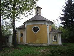
Lesní Hluboké
Lesní Hluboké is a village and municipality (obec) in Brno-Country District in the South Moravian Region of the Czech Republic.
Lesní Hluboké | |
|---|---|
Municipality | |
 | |
 Flag  Coat of arms | |
 Lesní Hluboké | |
| Coordinates: 49°16′19″N 16°18′35″E | |
| Country | |
| Region | South Moravian |
| District | Brno-Country |
| Area | |
| • Total | 4.96 km2 (1.92 sq mi) |
| Elevation | 503 m (1,650 ft) |
| Population (2006) | |
| • Total | 190 |
| • Density | 38/km2 (99/sq mi) |
| Postal code | 664 83 |
| Website | http://www.lesnihluboke.cz |
The municipality covers an area of 4.96 square kilometres (1.92 sq mi), and has a population of 190 (as at 3 July 2006).
Lesní Hluboké lies approximately 24 kilometres (15 mi) west of Brno and 164 km (102 mi) south-east of Prague.
This article is issued from Wikipedia. The text is licensed under Creative Commons - Attribution - Sharealike. Additional terms may apply for the media files.