Dolní Loučky
Dolní Loučky is a village and municipality (obec) in Brno-Country District in the South Moravian Region of the Czech Republic.
Dolní Loučky | |
|---|---|
Municipality | |
.jpg) Air view | |
 Flag  Coat of arms | |
 Dolní Loučky | |
| Coordinates: 49°21′32″N 16°21′25″E | |
| Country | |
| Region | South Moravian |
| District | Brno-Country |
| Area | |
| • Total | 8.13 km2 (3.14 sq mi) |
| Elevation | 283 m (928 ft) |
| Population | |
| • Total | 1,211 |
| • Density | 150/km2 (390/sq mi) |
| Postal code | 594 55 |
| Website | http://www.dolniloucky.cz |
The municipality covers an area of 8.13 square kilometres (3.14 sq mi), and has a population of 1,142.
Dolní Loučky lies approximately 26 kilometres (16 mi) north-west of Brno and 162 km (101 mi) south-east of Prague.
Gallery
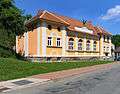 Orlovna (the gymnasium)
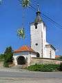 St. Martin's Church
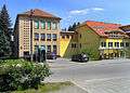 Old and new school
gollark: You're OBVIOUSLY just trying to make your own guesses superior to others'.
gollark: Suuuuuure.
gollark: Well, ALL is gollark.
gollark: Well, obviously my submission is.
gollark: Helloboious ones.
This article is issued from Wikipedia. The text is licensed under Creative Commons - Attribution - Sharealike. Additional terms may apply for the media files.