Lapid
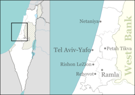
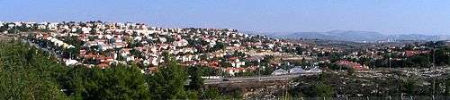
Lapid (Hebrew: לַפִּיד, lit. Torch) is an Israeli community settlement. Located in the Latrun Salient of the Green Line near Modi'in Illit, it falls under the jurisdiction of Hevel Modi'in Regional Council. In 2018 it had a population of 2,459.[1]
Lapid לַפִּיד | |
|---|---|
 Lapid | |
| Coordinates: 31°54′59.39″N 35°1′59.15″E | |
| Country | Israel |
| District | Central |
| Council | Hevel Modi'in |
| Founded | 1996 |
| Population (2018)[1] | 2,459 |
History
Lapid was established in 1996. According to B'Tselem, it was built on a strip of land designated no man's land inside the Green Line. Before the Six-Day War in 1967, this territory did not belong to either Jordan or Israel.[2]
According to ARIJ, Israel confiscated 441 dunam of land from the Palestinian village of Saffa after 1967 for the construction of Lapid.[3]
gollark: The chests can only store about... 30k furnaces total, so I need to dump them on people or it stops working.
gollark: I needed a few for some projects and upgraded it to see how far it could go.
gollark: For the second one, because I started a relentlessly efficient furnace production line.
gollark: I don't know.
gollark: Want 5000 furnaces, steamport?
References
- "Population in the Localities 2018" (XLS). Israel Central Bureau of Statistics. 25 August 2019. Retrieved 26 August 2019.
- Land grab: Israel's Settlement Policy in the West Bank Btselem
- Saffa village profile, ARIJ, p. 17
This article is issued from Wikipedia. The text is licensed under Creative Commons - Attribution - Sharealike. Additional terms may apply for the media files.