Lanark, Illinois
Lanark is a city in Carroll County, Illinois, United States. The population was 1,457 at the 2010 census, down from 1,584 at the 2000 census. The city was named after Lanark, in Scotland.[4]
Lanark | |
|---|---|
| The City of Lanark | |
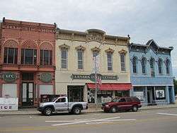 Historic commercial buildings in Lanark's business district | |
| Nickname(s): Tree City U.S.A. | |
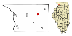 Location of Lanark in Carroll County, Illinois. | |
.svg.png) Location of Illinois in the United States | |
| Coordinates: 42°06′08″N 89°50′00″W | |
| Country | United States |
| State | Illinois |
| County | Carroll |
| Founded | 1861 |
| Government | |
| • Type | Mayor-Council |
| • Mayor | Kenneth Viglietta |
| Area | |
| • Total | 1.13 sq mi (2.91 km2) |
| • Land | 1.13 sq mi (2.91 km2) |
| • Water | 0.00 sq mi (0.00 km2) |
| Elevation | 879 ft (268 m) |
| Population (2010) | |
| • Total | 1,457 |
| • Estimate (2019)[3] | 1,333 |
| • Density | 1,184.89/sq mi (457.50/km2) |
| Time zone | UTC-6 (CST) |
| • Summer (DST) | UTC-5 (CDT) |
| ZIP Code(s) | 61046 |
| Area code(s) | 815 |
| FIPS code | 17-41859 |
| Wikimedia Commons | Lanark, Illinois |
| Website | http://www.lanarkil.com/ |
History
Under the auspices of the Chicago, Milwaukee, St. Paul and Pacific Railroad, Daniel W. Dame purchased 500 acres (200 ha), laid out the city of Lanark, and was elected its first mayor in 1861. In 1886, 40 residents each donated one dollar to form a public library, and a primary and secondary school was completed in August 1867. On November 25, 1893, the original school was destroyed by fire.[5]
Early in the Twentieth Century, Lanark was home to the Cotta steam car company.[6]
In 1986 Lanark High School was consolidated with nearby Shannon High School to form the Eastland School District. The high school and grade school were originally located in Lanark, with the middle school in Shannon. After the end of the 2012–2013 school year, the Eastland School Board made the decision to close the Elementary building in Lanark, and move those students to the Shannon building. The Middle School students were then relocated to the High School building in Lanark, now known as the Eastland Jr/Sr High School.
Demographics
| Historical population | |||
|---|---|---|---|
| Census | Pop. | %± | |
| 1870 | 972 | — | |
| 1880 | 1,198 | 23.3% | |
| 1890 | 1,295 | 8.1% | |
| 1900 | 1,306 | 0.8% | |
| 1910 | 1,175 | −10.0% | |
| 1920 | 1,297 | 10.4% | |
| 1930 | 1,208 | −6.9% | |
| 1940 | 1,292 | 7.0% | |
| 1950 | 1,359 | 5.2% | |
| 1960 | 1,473 | 8.4% | |
| 1970 | 1,495 | 1.5% | |
| 1980 | 1,483 | −0.8% | |
| 1990 | 1,382 | −6.8% | |
| 2000 | 1,584 | 14.6% | |
| 2010 | 1,457 | −8.0% | |
| Est. 2019 | 1,333 | [3] | −8.5% |
| U.S. Decennial Census[7] | |||
As of the census[8] of 2000, there were 1,584 people, 644 households, and 441 families residing in the city. The population density was 1,525.7 people per square mile (588.1/km2). There were 693 housing units at an average density of 667.5 per square mile (257.3/km2). The racial makeup of the city was 97.10% White, 0.06% African American, 0.32% Native American, 1.07% Asian, 0.06% from other races, and 1.39% from two or more races. Hispanic or Latino of any race were 0.25% of the population.
There were 645 households out of which 31.8% had children under the age of 18 living with them, 57.0% were married couples living together, 9.0% had a female householder with no husband present, and 31.4% were non-families. 27.2% of all households were made up of individuals and 16.0% had someone living alone who was 65 years of age or older. The average household size was 2.43 and the average family size was 2.96.
The average age of residents is spread out, with 25.6% under the age of 18, 6.3% from 18 to 24, 28.7% from 25 to 44, 21.4% from 45 to 64, and 18.0% who were 65 years of age or older. The median age was 39 years. For every 100 females, there were 97.0 males. For every 100 females age 18 and over, there were 88.9 males.
The median income for a household in the city was $35,500, and the median income for a family was $45,800. Males had a median income of $31,705 versus $21,576 for females. The per capita income for the city was $17,518. About 5.6% of families and 8.0% of the population were below the poverty line, including 8.9% of those under age 18 and 6.9% of those age 65 or over.
Geography
Lanark is located at 42°6′5″N 89°49′56″W (42.101346, -89.832120).[9]
According to the 2010 census, Lanark has a total area of 1.12 square miles (2.90 km2), all land.[10]
Climate
| Climate data for Lanark, Illinois | |||||||||||||
|---|---|---|---|---|---|---|---|---|---|---|---|---|---|
| Month | Jan | Feb | Mar | Apr | May | Jun | Jul | Aug | Sep | Oct | Nov | Dec | Year |
| Average high °F (°C) | 28 (−2) |
36 (2) |
46 (8) |
61 (16) |
72 (22) |
82 (28) |
84 (29) |
82 (28) |
75 (24) |
64 (18) |
46 (8) |
34 (1) |
59 (15) |
| Average low °F (°C) | 7 (−14) |
12 (−11) |
25 (−4) |
36 (2) |
46 (8) |
54 (12) |
59 (15) |
55 (13) |
46 (8) |
36 (2) |
27 (−3) |
14 (−10) |
35 (2) |
| Average precipitation inches (mm) | 1.43 (36.3) |
1.52 (38.6) |
2.63 (66.8) |
3.67 (93.2) |
4.34 (110.2) |
4.77 (121.2) |
3.83 (97.3) |
4.54 (115.3) |
3.48 (88.4) |
2.73 (69.3) |
2.84 (72.1) |
2.02 (51.3) |
37.8 (960) |
| Source: weather.com[11] | |||||||||||||
Education
Lanark is a part of Eastland Community Unit School District #308, which also includes Shannon, IL. Lanark and Shannon are the home of the Eastland Cougars. Eastland Elementary School, located in Shannon, IL and Eastland High School are both apart of the district.
References
- "2019 U.S. Gazetteer Files". United States Census Bureau. Retrieved July 14, 2020.
- "USGS detail on Newtown". Retrieved 2007-10-21.
- "Population and Housing Unit Estimates". United States Census Bureau. May 24, 2020. Retrieved May 27, 2020.
- Gannett, Henry (1905). The Origin of Certain Place Names in the United States. Government Printing Office. pp. 180.
- http://www.illinoishsglorydays.com/id67.html
- Georgano, G.N. Cars: Early and Vintage, 1886-1930. (London: Grange-Universal, 1985).
- "Census of Population and Housing". Census.gov. Retrieved June 4, 2015.
- "U.S. Census website". United States Census Bureau. Retrieved 2008-01-31.
- "US Gazetteer files: 2010, 2000, and 1990". United States Census Bureau. 2011-02-12. Retrieved 2011-04-23.
- "G001 - Geographic Identifiers - 2010 Census Summary File 1". United States Census Bureau. Archived from the original on 2020-02-13. Retrieved 2015-12-27.
- "Monthly Averages for Lanark, Illinois". The Weather Channel. Retrieved 2011-05-14.
External links
- Lanark Chamber of Commerce
- City of Lanark Homepage
- Eastland School District
- Carroll County Government
- Visit Carroll County
Municipalities and communities of Carroll County, Illinois, United States | ||
|---|---|---|
| Cities | Map of Illinois highlighting Carroll County | |
| Villages | ||
| Townships |
| |
| Unincorporated communities | ||
| Ghost town | ||
| Footnotes | ‡This populated place also has portions in an adjacent county or counties | |