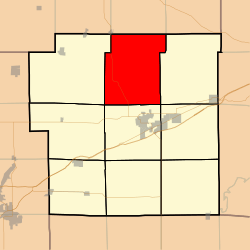
Lagrange Township, Bond County, Illinois
Lagrange Township is one of nine townships in Bond County, Illinois, USA. As of the 2010 census, its population was 1,169 and it contained 507 housing units.[2]
Lagrange Township | |
|---|---|
 Location in Bond County | |
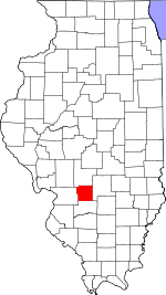
 Bond County's location in Illinois | |
| Coordinates: 38°58′31″N 89°25′50″W | |
| Country | United States |
| State | Illinois |
| County | Bond |
| Settlement | November 6, 1888 |
| Area | |
| • Total | 46.48 sq mi (120.4 km2) |
| • Land | 45.61 sq mi (118.1 km2) |
| • Water | 0.87 sq mi (2.3 km2) 1.87% |
| Elevation | 571 ft (174 m) |
| Population (2010) | |
| • Estimate (2016)[1] | 1,107 |
| • Density | 25.6/sq mi (9.9/km2) |
| Time zone | UTC-6 (CST) |
| • Summer (DST) | UTC-5 (CDT) |
| ZIP codes | 62019, 62086, 62246, 62262 |
| FIPS code | 17-005-40741 |
Geography
According to the 2010 census, the township has a total area of 46.48 square miles (120.4 km2), of which 45.61 square miles (118.1 km2) (or 98.13%) is land and 0.87 square miles (2.3 km2) (or 1.87%) is water.[2]
Unincorporated towns
Extinct settlements
- Elm Point
Cemeteries
The township contains these four cemeteries: Elm Point, Jett Number, Union Grove and Wright.
Major highways

Lakes
- Governor Bond Lake
School districts
- Bond County Community Unit School District 2
- Hillsboro Community Unit School District 3
- Mulberry Grove Community Unit School District 1
Political districts
- Illinois' 19th congressional district
- State House District 102
- State Senate District 51
gollark: Maybe it does work by word somehow.
gollark: > I don't have patience to mess with this much, but I was suspecting that the autogenerated "I consider it interesting" quotes on the root page above the auction give random pairs of words that are equal in His eyes.That is... interesting.
gollark: I can't believe that He likes apiogollarioforms more than semiapiosteganohazards.
gollark: It says "you." after it, thus insult.
gollark: Yes, it was an insult directed at you.
References
- "Lagrange Township, Bond County, Illinois". Geographic Names Information System. United States Geological Survey. Retrieved 2010-01-04.
- United States Census Bureau 2007 TIGER/Line Shapefiles
- United States National Atlas
- "Population and Housing Unit Estimates". Retrieved June 9, 2017.
- "Population, Housing Units, Area, and Density: 2010 - County -- County Subdivision and Place -- 2010 Census Summary File 1". United States Census. Archived from the original on 2020-02-12. Retrieved 2013-05-28.
- "Census of Population and Housing". Census.gov. Retrieved June 4, 2016.
External links
This article is issued from Wikipedia. The text is licensed under Creative Commons - Attribution - Sharealike. Additional terms may apply for the media files.