La Paloma, Montevideo
La Paloma - Tomkinson is a barrio (neighbourhood or district) of Montevideo, Uruguay.
La Paloma - Tomkinson | |
|---|---|
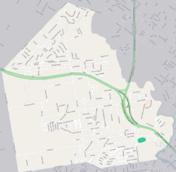 Street map of La Paloma - Tomkinson | |
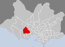 Location of La Paloma - Tomkinson in Montevideo | |
| Coordinates: 34°51′37″S 56°16′6″W | |
| Country | |
| Department | Montevideo Department |
| City | Montevideo |
Location
It shares borders with Villa del Cerro to the south, Casabó to the south and west, Paso de la Arena to the north, Nuevo París and Tres Ombúes–Pueblo Victoria to the east. La Paloma is a northern extension of the Villa del Cerro, while Tomkinson is mostly north of Route 1.
gollark: I'll try using the oracle JRE instead of OpenJDK or something.
gollark: It works non-laggishly on 4GB. The issue is that it crashes with errors about failing to allocate memory fairly often.
gollark: I think I set it to 4GB.
gollark: I'd probably play more if the server was busier and the pack somewhat less computationally heavy.
gollark: 8GB.
See also

This article is issued from Wikipedia. The text is licensed under Creative Commons - Attribution - Sharealike. Additional terms may apply for the media files.