La Blanqueada
La Blanqueada is a barrio (neighbourhood or district) of Montevideo, Uruguay.
La Blanqueada | |
|---|---|
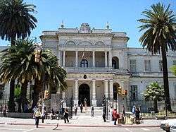 The Military Hospital | |
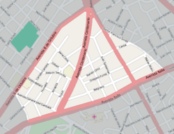 Street map of La Blanqueada | |
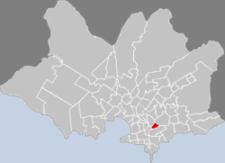 Location of La Blanqueada in Montevideo | |
| Coordinates: 34°53′11″S 56°9′14″W | |
| Country | |
| Department | Montevideo Department |
| City | Montevideo |
Location
It borders Tres Cruces to the west, Larrañaga to the northwest, Unión to the northeast and Parque Batlle to the south. It is home to the Military Hospital.
Several main avenues border and cross this barrio: 8 de Octubre Avenue, Italia Avenue, Dr. Luis Alberto de Herrera Avenue and Centenario Avenue.
According to the historian Orestes Araújo, the name of this neighbourhood (derived from blanco, Spanish for "white") was given by an old grocery store all in white.
Places of worship
- Parish Church of Our Lady of the Assumption, known also as the Italian Catholic Mission (Roman Catholic, Scalabrinians)[1][2]
gollark: I did that after it came up with some error.
gollark: ```lua fix_node = function(instance) if not debuggetupvalue then return end local i = 1 while true do local n, v = debuggetupvalue(instance, i) if not n then break end if n == "isRunning" then debugsetupvalue(instance, i, false) end if n == "procs" then debug.setupvalue(instance, i, {}) end i = i + 1 end end```
gollark: <@!113673208296636420> ```lua if node then if potatOS.fix_node then potatOS.fix_node(node.init) end node.on("dummy", function() end) process.spawn(node.init, "node") end```
gollark: ||potaTodfpwm||
gollark: ||your parents were both gay||
See also
References
- Scalabrinians in Uruguay
- Scalabrininan Parish in La Blanqueada Archived 2013-05-15 at the Wayback Machine
External links
This article is issued from Wikipedia. The text is licensed under Creative Commons - Attribution - Sharealike. Additional terms may apply for the media files.