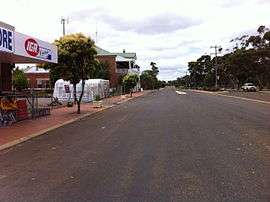
Kukerin, Western Australia
Kukerin is a small town in the Wheatbelt region of Western Australia, 308 kilometres (191 mi) south-east of Perth between Dumbleyung and Lake Grace just off Dumbleyung Lake Grace Road on State Route 107. The town itself is small but services a considerable agricultural region in the eastern Shire of Dumbleyung. At the 2016 census, Kukerin and its surrounding areas had a population of 166.[1]
| Kukerin Western Australia | |
|---|---|
 Main street in Kukerin. | |
 Kukerin Location in Western Australia | |
| Coordinates | 33.188°S 118.084°E |
| Population | 166 (2016 census)[1] |
| Established | 1907 |
| Postcode(s) | 6352 |
| Location | |
| LGA(s) | Shire of Dumbleyung |
| State electorate(s) | Roe |
| Federal Division(s) | O'Connor |
History
According to an official source, Kukerin's name is of Aboriginal origin, was first recorded as the name of a local soak and gully in 1908 and has also been spelled "Cookerin", but the precise meaning is not known.[2] However, in local languages, words such as karkar mean "east", and the townsite is near the eastern edge of country traditionally owned by the Wiilman people.[3][4] There is no evidence for a popular theory that the area was named after sandalwood cutters named "Cooke" and "Ring".
Until 1912, the area was known as Merilup (a name that now refers to an area to the south). In the 1870s, John Holland took up a pastoral lease of 9,000 acres (36 km2) in the area and established a sandalwood depot. Sandalwood cutters opened up much of the surrounding area, and in 1904 the Rabbit-Proof Fence was built near the town.
In 1912, the town was gazetted when it became the terminus of an extension of the Wagin to Dumbleyung train line in 1912.[2] The primary school and hall were built in 1914, and Kukerin Hotel began trading in 1928—all are still open to this day.
Present day
Kukerin is largely an agricultural town, with wheat and sheep farming being the main occupations. The town contains a secondary receival site for Cooperative Bulk Handling and one of the state's three Bunge grain depots 9 kilometres (6 mi) west of the main town.[5][6] It functions as a service town for the surrounding agricultural area, and contains a general store, primary school, hotel, newsagency/post office, and the Nenke Park sports fields. The TrachMach Fair used to be held with various vintage and modern vehicles on display.[7] In recent years this has transformed into the Kukerin Creekbed and Burnout Competition,[8] which is held during the Queen's Birthday long weekend and is hosted at Nenke Park. During this event a large screen is set up where the AFL Grand Final can be viewed.[9]
| Climate data for Kukerin (climate data: 1912–2020) | |||||||||||||
|---|---|---|---|---|---|---|---|---|---|---|---|---|---|
| Month | Jan | Feb | Mar | Apr | May | Jun | Jul | Aug | Sep | Oct | Nov | Dec | Year |
| Average rainfall mm (inches) | 16.1 (0.63) |
18.5 (0.73) |
20.8 (0.82) |
25.5 (1.00) |
48.1 (1.89) |
58.5 (2.30) |
57.6 (2.27) |
49.5 (1.95) |
35.8 (1.41) |
27.0 (1.06) |
19.9 (0.78) |
15.0 (0.59) |
396.4 (15.61) |
| Source: Bureau of Meteorology[10][11] | |||||||||||||
References
-
- Australian Bureau of Statistics (27 June 2017). "South Kukerin (State Suburb)". 2016 Census QuickStats. Retrieved 9 April 2019.

- Australian Bureau of Statistics (27 June 2017). "Kukerin (State Suburb)". 2016 Census QuickStats. Retrieved 9 April 2019.

- Australian Bureau of Statistics (27 June 2017). "North Kukerin (State Suburb)". 2016 Census QuickStats. Retrieved 9 April 2019.

- Australian Bureau of Statistics (27 June 2017). "South Kukerin (State Suburb)". 2016 Census QuickStats. Retrieved 9 April 2019.
- Western Australian Land Information Authority. "History of country town names – K". Retrieved 17 April 2007.
- Nicholas Thieberger 1996, "4.2.9 Wiilman", Handbook of Western Australian Aboriginal Languages, South of the Kimberley Archived 8 June 2013 at the Wayback Machine (2 February 2015).
- [South Australian Museum, 2014, "Wudjari (WA)", Tindale Tribes (2 February 2015).
- "CBH receival sites" (PDF). 2011. Archived from the original (PDF) on 18 March 2012. Retrieved 1 April 2013.
- "WA Site Information". 2019. Retrieved 9 April 2019.
- "Nenke Park". Retrieved 21 August 2019.
- "Get Down and Dirty at Kukerin". Retrieved 12 March 2019.
- Information available from Shire of Dumbleyung, contacted 27 October 2006.
- Western Australian Climate Services Centre (Bureau of Meteorology) (March 2020). "Kukerin Climate Averages" (Webpage). Retrieved 23 March 2012.
- Western Australian Climate Services Centre (Bureau of Meteorology) (March 2012). "Kukerin Climatic Extremes" (Webpage). Retrieved 4 March 2020.