Kroppen
Kroppen is a municipality in the Oberspreewald-Lausitz district, in southern Brandenburg, Germany.
Kroppen | |
|---|---|
Location of Kroppen within Oberspreewald-Lausitz district   | |
 Kroppen  Kroppen | |
| Coordinates: 51°22′59″N 13°48′00″E | |
| Country | Germany |
| State | Brandenburg |
| District | Oberspreewald-Lausitz |
| Municipal assoc. | Ortrand |
| Subdivisions | 2 Ortsteile |
| Government | |
| • Mayor | Reiner Krämer (CDU) |
| Area | |
| • Total | 15.16 km2 (5.85 sq mi) |
| Elevation | 112 m (367 ft) |
| Population (2018-12-31)[1] | |
| • Total | 696 |
| • Density | 46/km2 (120/sq mi) |
| Time zone | CET/CEST (UTC+1/+2) |
| Postal codes | 01945 |
| Dialling codes | 035755 |
| Vehicle registration | OSL |
| Website | www.kroppen-osl.de |
Demography
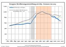
Development of Population since 1875 within the Current Boundaries (Blue Line: Population; Dotted Line: Comparison to Population Development of Brandenburg state; Grey Background: Time of Nazi rule; Red Background: Time of Communist rule)
|
|
gollark: This really does sound like an "OS" to me.
gollark: DOT DOT DOT
gollark: If you don't, depth first search I guess?
gollark: If you already have a map of it before you start I think this would be a minimum spanning tree thing.
gollark: So you want to go through every cell of a maze?
References
- "Bevölkerung im Land Brandenburg nach amtsfreien Gemeinden, Ämtern und Gemeinden 31. Dezember 2018". Amt für Statistik Berlin-Brandenburg (in German). July 2019.
- Detailed data sources are to be found in the Wikimedia Commons.Population Projection Brandenburg at Wikimedia Commons
Towns and municipalities in Oberspreewald-Lausitz | ||
|---|---|---|
Coat of Arms of Oberspreewald-Lausitz district | ||
| Authority control |
|
|---|
This article is issued from Wikipedia. The text is licensed under Creative Commons - Attribution - Sharealike. Additional terms may apply for the media files.