Krasnogorodsky District
Krasnogorodsky District (Russian: Красногоро́дский райо́н) is an administrative[1] and municipal[2] district (raion), one of the twenty-four in Pskov Oblast, Russia. It is located in the west of the oblast and borders with Ostrovsky District in the north, Pushkinogorsky District in the northeast, Opochetsky District in the southeast, Sebezhsky District in the south, Cibla and Kārsava municipalities of Latvia in the southwest, and with Pytalovsky District in the west. The area of the district is 1,320.42 square kilometers (509.82 sq mi).[3] Its administrative center is the urban locality (a work settlement) of Krasnogorodsk.[2] Population: 7,328 (2010 Census);[4] 9,800 (2002 Census);[8] 11,886 (1989 Census).[9] The population of Krasnogorodsk accounts for 52.8% of the district's total population.[4]
Krasnogorodsky District Красногородский район | |
|---|---|
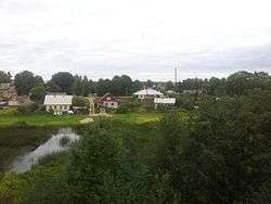
 View of Krasnogorodsk | |
.png) Coat of arms | |

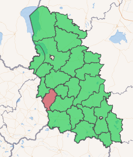
Location of Krasnogorodsky District in Pskov Oblast | |
| Coordinates: 56°49′44″N 28°16′51″E | |
| Country | Russia |
| Federal subject | Pskov Oblast[1] |
| Established | 1927 |
| Administrative center | Krasnogorodsk[2] |
| Area | |
| • Total | 1,320.42 km2 (509.82 sq mi) |
| Population | |
| • Total | 7,328 |
| • Estimate (2018)[5] | 6,841 (-6.6%) |
| • Density | 5.5/km2 (14/sq mi) |
| • Urban | 52.8% |
| • Rural | 47.2% |
| Administrative structure | |
| • Inhabited localities[2] | 1 Urban-type settlements[6], 220 Rural localities |
| Municipal structure | |
| • Municipally incorporated as | Krasnogorodsky Municipal District[2] |
| • Municipal divisions[2] | 1 Urban settlements, 3 Rural settlements |
| Time zone | UTC+3 (MSK |
| OKTMO ID | 58614000 |
| Website | http://krasnogorodsk.reg60.ru/ |
Geography
The district lies in the basin of the Velikaya River and thus of the Narva River. The most significant rivers in the district are the Sinyaya and the Lzha, both originating in Latvia. The Sinyaya, a tributary of the Velikaya, crosses the district from south to north. In particular, the settlement of Krasnogorodsk is located on the banks of the Sinyaya. The Lzha, a tributary of the Utroya, forms a stretch of the state border between Russia and Latvia and proceeds to form the border between Krasnogorodsky and Pytalovsky Districts. A number of lakes are located in the district. The biggest ones are Lakes Velye (shared with Ostrovsky District), Pitel (shared with Latvia), and Vysokoye.
Over half of the district's territory is occupied by forests.[10]
History
In the medieval times, the area belonged to Pskov. Krasnogorodsk was founded in 1464 as Krasny Gorodets and was a fortress protecting Pskov from the southwest—one of the directions the Livonian Order was likely to advance from. In the beginning of the 15th century, together with Pskov, the area was annexed by the Grand Duchy of Moscow. In 1581, Krasny Gorodets was conquered by the Polish Army and burned down. In 1607, it was again conquered by Lithuanians. In 1634, peace between Russia and Poland was concluded, and the area was transferred to the Polish–Lithuanian Commonwealth. It was returned to Russia under one of the provisions of the Truce of Andrusovo in 1667.[11]
In the course of the administrative reform carried out in 1708 by Peter the Great, the area was included into Ingermanland Governorate (known since 1710 as Saint Petersburg Governorate). In 1727, separate Novgorod Governorate was split off, and in 1772, Pskov Governorate (which between 1777 and 1796 existed as Pskov Viceroyalty) was established. The area was a part of Opochetsky Uyezd of Pskov Governorate.
On August 1, 1927, the uyezds were abolished, and Krasnogorodsky District was established, with the administrative center in the settlement of Krasnogorodskoye (currently Krasnogorodsk). It included parts of former Opochetsky Uyezd. The governorates were abolished as well, and the district became a part of Pskov Okrug of Leningrad Oblast. On July 23, 1930, the okrugs were also abolished, and the districts were directly subordinated to the oblast. On January 1, 1932, the district was abolished and split between Pushkinsky, Ostrovsky, and Opochetsky Districts. On March 5, 1935, the district was re-established from parts of the territories of Pushkinsky and Opochetsky Districts. Between May 11, 1935 and February 5, 1941, Krasnogorodsky District was a part of Opochka Okrug of Leningrad Oblast, one of the okrugs abutting the state boundaries of the Soviet Union. Between 1941 and 1944, the district was occupied by German troops. On August 22, 1944, the district was transferred to newly established Velikiye Luki Oblast. On October 2, 1957, the oblast was abolished and Krasnogorodsky District was transferred to Pskov Oblast. On February 1, 1963, the district was abolished and merged into Opochetsky District; on December 30, 1966 it was re-established. In 1967, Krasnogorodskoye was granted urban-type settlement status, and in 1995 it was renamed Krasnogorodsk.[12]
Restricted access
The part of the district along the state border is included into a border security zone, intended to protect the borders of Russia from unwanted activity. In order to visit the zone, a permit issued by the local Federal Security Service department is required.[13]
Economy
Industry
The industry in the district is represented by food and textile production.[14]
Transportation
Krasnogorodsk is connected by roads with Opochka and with Kārsava in Latvia, and has access to the European route E262, running from Ostrov to Kaunas via Rēzekne and Daugavpils. The stretch between Ostrov and Latvian border has been a toll road since 2002.[15] There are also local roads.
Culture and recreation
The district contains one cultural heritage monument of federal significance and additionally thirty objects classified as cultural and historical heritage of local significance.[16] The federally protected monument is an archeological site.
References
Notes
- Law #833-oz
- Law #420-oz
- О районе (in Russian). Портал муниципальных образований Псковской области. Retrieved July 17, 2012.
- Russian Federal State Statistics Service (2011). "Всероссийская перепись населения 2010 года. Том 1" [2010 All-Russian Population Census, vol. 1]. Всероссийская перепись населения 2010 года [2010 All-Russia Population Census] (in Russian). Federal State Statistics Service.
- "26. Численность постоянного населения Российской Федерации по муниципальным образованиям на 1 января 2018 года". Federal State Statistics Service. Retrieved January 23, 2019.
- The count of urban-type settlements may include the work settlements, the resort settlements, the suburban (dacha) settlements, as well as urban-type settlements proper.
- "Об исчислении времени". Официальный интернет-портал правовой информации (in Russian). June 3, 2011. Retrieved January 19, 2019.
- Russian Federal State Statistics Service (May 21, 2004). "Численность населения России, субъектов Российской Федерации в составе федеральных округов, районов, городских поселений, сельских населённых пунктов – районных центров и сельских населённых пунктов с населением 3 тысячи и более человек" [Population of Russia, Its Federal Districts, Federal Subjects, Districts, Urban Localities, Rural Localities—Administrative Centers, and Rural Localities with Population of Over 3,000] (XLS). Всероссийская перепись населения 2002 года [All-Russia Population Census of 2002] (in Russian).
- "Всесоюзная перепись населения 1989 г. Численность наличного населения союзных и автономных республик, автономных областей и округов, краёв, областей, районов, городских поселений и сёл-райцентров" [All Union Population Census of 1989: Present Population of Union and Autonomous Republics, Autonomous Oblasts and Okrugs, Krais, Oblasts, Districts, Urban Settlements, and Villages Serving as District Administrative Centers]. Всесоюзная перепись населения 1989 года [All-Union Population Census of 1989] (in Russian). Институт демографии Национального исследовательского университета: Высшая школа экономики [Institute of Demography at the National Research University: Higher School of Economics]. 1989 – via Demoscope Weekly.
- Географическая характеристика (in Russian). Портал муниципальных образований Псковской области. Retrieved July 17, 2012.
- История района (in Russian). Портал муниципальных образований Псковской области. Retrieved July 18, 2012.
- Герасимёнок, Т. Е.; Н. В. Коломыцева, И. С. Пожидаев, С. М. Фёдоров, К. И. Карпов (2002). Территориальное деление Псковской области (in Russian). Pskov. ISBN 5-94542-031-X.CS1 maint: multiple names: authors list (link)
- Приказ ФСБ РФ от 2 июня 2006 года №242 "О пределах пограничной зоны на территории Псковской области"; Приказ ФСБ России от 21 апреля 2007 г. №201 "О внесении изменения в приказ ФСБ России 2 июня 2006 года №242 "О пределах пограничной зоны на территории Псковской области". Rossiyskaya Gazeta (in Russian). 2006.
- Экономика (in Russian). Портал муниципальных образований Псковской области. Retrieved July 18, 2012.
- "Archived copy" Псковская обл. Платные дороги (in Russian). АСМАП. Archived from the original on July 14, 2014. Retrieved October 16, 2012.CS1 maint: archived copy as title (link)
- Памятники истории и культуры народов Российской Федерации (in Russian). Russian Ministry of Culture. Retrieved June 2, 2016.
Sources
- Псковское областное Собрание депутатов. Закон №833-оз от 5 февраля 2009 г. «Об административно-территориальном устройстве Псковской области». Вступил в силу со дня официального опубликования. Опубликован: "Псковская правда", №20, 10 февраля 2009 г. (Pskov Oblast Council of Deputies. Law #833-oz of February 5, 2009 On the Administrative-Territorial Structure of Pskov Oblast. Effective as of the official publication date.).
- Псковское областное Собрание депутатов. Закон №420-оз от 28 февраля 2005 г. «Об установлении границ и статусе вновь образуемых муниципальных образований на территории Псковской области», в ред. Закона №1542-ОЗ от 5 июня 2015 г. «О внесении изменений в Закон Псковской области "Об установлении границ и статусе вновь образуемых муниципальных образований на территории Псковской области"». Вступил в силу со дня официального опубликования. Опубликован: "Псковская правда", №41–43, №44–46, №49–51, 4 марта 2005 г., 5 марта 2005 г., 11 марта 2005 г. (Pskov Oblast Council of Deputies. Law #420-oz of February 28, 2005 On Establishing the Borders and the Status of the Newly Formed Municipal Formations on the Territory of Pskov Oblast, as amended by the Law #1542-OZ of June 5, 2015 On Amending the Law of Pskov Oblast "On Establishing the Borders and the Status of the Newly Formed Municipal Formations on the Territory of Pskov Oblast". Effective as of the official publication date.).